


Summary
The Old City of Hebron (Arabic: البلدة القديمة الخليل Hebrew: עיר העתיקה של חברון) is the historic city centre of Hebron in the West Bank, Palestine. The Hebron of antiquity is thought by archaeologists to have originally started elsewhere, at Tel Rumeida, which is approximately 200 meters (660 ft) west of today's Old City, and thought to have originally been a Canaanite city. Today's Old City was settled in Greek or Roman times (circa 3rd to 1st centuries BCE). It became the center of the overall Hebron site during the Abbasid Caliphate (which began circa 750 CE).
| UNESCO World Heritage Site | |
|---|---|
 Old City of Hebron | |
| Official name | Hebron/Al-Khalil Old Town |
| Location | Hebron, West Bank, State of Palestine |
| Includes | Cave of the Patriarchs |
| Criteria | Cultural: ii, iv, vi |
| Reference | 1565 |
| Inscription | 2017 (41st Session) |
| Endangered | 2017– |
| Area | 20.6 ha (0.080 sq mi) |
| Buffer zone | 152.2 ha (0.588 sq mi) |
| Coordinates | 31°31′31″N 35°06′30″E / 31.52528°N 35.10833°E |
It was recognized as the third World Heritage Site in the State of Palestine in 2017.[1]
The Old City is built around the Cave of the Patriarchs, the traditional burial site of the biblical Patriarchs and Matriarchs, and venerated by Jews, Christians, and Muslims. The Old City is a sensitive location in the Israeli–Palestinian conflict in Hebron.
History edit

The present Old City was first settled in either the Greek or at the latest by Roman times.[2][3] It was settled in the valley downhill from Tel Rumeida, considered to be the center of biblical Hebron.[4] It was not until the start of the Abbasid Caliphate that the current city became the center of Hebron, building up around the focal point of the Cave of the Patriarchs.[5]
The urban structure of the Old City of Hebron dates to the Mamluk period, and has remained mostly unchanged.[6] A majority of the buildings are Ottoman-era from the eighteenth century along with some half dozen Mamluk structures.[7] It is composed of a number of cell-like quarters with narrowly packed fortified houses functioning as a boundary to each area, with gates at the end of the main streets.[8] It has an approximate area of 20.6 hectares (51 acres; 0.206 km2), housing thousands of residents.
It became the third World Heritage Site in the State of Palestine in 2017,[9] and was inscribed on the official List of World Heritage in Danger as "Palestine, Hebron/Al-Khalil Old Town".[10]

The 1997 Hebron Agreement, part of the Oslo Accords, placed the Old City in area "H2", maintaining the Israeli military control which it has been under since 1967.[11] According to Btselem report , the Palestinian population in the Old City greatly declined since the early 1980s because of the impact of Israeli security measures, including extended curfews, strict restrictions on movement and the closure of Palestinian commercial activities near settler areas, and also due to settler harassment.[12][13][14][15] The IDF responded to the report by saying that "The IDF is well aware that curfews are seen as drastic measures, not to be used except for situations where they are essential for protecting the lives of civilians and soldiers ...Hebron is the only Palestinian city in which Israeli and Palestinian residents live side by side. Due to this, and the large number of terrorist attacks against the Israeli residents and the IDF soldiers protecting them, the city poses a complex security challenge."[12] The efforts of the internationally funded Hebron Rehabilitation Committee resulted in the return of more than 6,000 Palestinians by 2015.[16] In 2019, the Temporary International Presence in Hebron was expelled from the city.[17] It issued a confidential report which found that Israel routinely violates international law in Hebron and that it is in "severe and regular breach" of the rights to non-discrimination laid out in the International Covenant on Civil and Political Rights over the lack of freedom to movement for the Palestinian residents of Hebron.[18]
The rehabilitation of the Old City won the Aga Khan Award for Architecture in 1998.[19]
Landmarks edit


1. Tomb of the Patriarchs;
2. The Castle, partly ruined;
3. Pool;
4. Pool;
5. Old well;
6. Old well;
7. Bijurd mosque;
8. Aly Bukka mosque "the second chief building in Hebron";
A. Sheikh 'Aly Bakka quarter Arabic: حارة الشيخ علي البكا;
B. Zawiya quarter (Haret ez Zawieh) Arabic: حارة باب الزاوية;
C. Glassmakers quarter (Haret Kezazin) Arabic: حارة القزازين (see Hebron glass);
D. el Akkabeh (quarter of the ascent) Arabic: حارة العقّابة;
E. Haram quarter Arabic: حارة الحرم;
F. Muheisin quarter (name of a family);
G. Cotton quarter (Haret Kotton) Arabic: حارة قيطون;
H. the eastern quarter (Haret Mesherky) Arabic: حارة المشارقة;
Places of worship edit
- Cave of the Patriarchs, including the Al-Jawali Mosque, the Uthman ibn Affan mosque and the Ibrahim hospice
- Sheikh Ali al-Bakka Mosque
- Qazzazin Mosque
- Avraham Avinu Synagogue
Museums edit
- Old City Museum
Districts and subdivisions edit
At the end of the 19th century, the Old City was recorded as being divided into nine quarters:[20]
- Sheikh 'Aly Bakka quarter Arabic: حارة الشيخ علي البكا;
- Zawiya quarter (Haret ez Zawieh) Arabic: حارة باب الزاوية;
- Glassmakers quarter (Haret Kezazin) Arabic: حارة القزازين (see Hebron glass);
- el Akkabeh (quarter of the ascent) Arabic: حارة العقّابة;
- Haram quarter Arabic: حارة الحرم;
- Muheisin quarter (name of a family);
- Cotton quarter (Haret Kotton) Arabic: حارة قيطون;
- The eastern quarter (Haret Mesherky) Arabic: حارة المشارقة;
- The new quarter Arabic: حارة الجديد;
The Old City includes three small Israeli settlements on its periphery – Beit Hadassah, Beit Romano, and Avraham Avinu – which have been described as forming a "loosely contiguous Jewish neighbourhood"[21] or a "Jewish Quarter".[22] The Jewish area in the late 19th century was in the Glassmakers quarter (Haret Kezazin).[23][24]
Israeli segregation edit
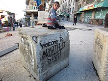
The Palestinian population in H2 has greatly declined because of the impact of Israeli security measures, including extended curfews, strict restrictions on movement,[26] and the closure of Palestinian commercial activities near settler areas, and also due to settler harassment.[27][28][29][15] Palestinians are barred from using Al-Shuhada Street, a principal commercial thoroughfare that is locally nicknamed "Apartheid Street as a result.[30][31]
UNESCO nomination edit
The U.S has provided no funding to UNESCO since Palestine was admitted as a full member in 2011. The Obama administration cited a pre-existing law[32] that prohibits funding any UN agency or affiliate that grants full membership to non-states,[33] which was put in place after Palestine applied for UNESCO and WHO membership in April 1989.[34][35] The U.S. and Israel were among just 14 of 194 members that voted against admitting the Palestinians in 2011.[36]
The Executive summary, the Nomination Text, Annexes and Maps (all files located here) are the documents submitted by Palestine to the World Heritage Centre on 30 January 2017 and requested for expedited consideration on May 21, 2017.[37] The International Council on Monuments and Sites (ICOMOS) subsequently sought access to the Old City of Hebron but Israel refused it entry because "On a strategic and principled level, the State of Israel will not take part in and will not legitimize any Palestinian political move under the guise of culture and heritage."[38]
Reporting on the ICOMOS report, the Jerusalem Post noted that "the association of Hebron with Jewish and early Christian societies is given little recognition, and Tell Rumeida [an area of Biblical Hebron] and other sites are excluded from the boundaries," and that "the PA would have done better with an expanded timeline and larger geographical area of the city, which could have spoken of its importance to the development of three monotheistic religions starting from 2200 BCE." while also writing that "The absence of a field visit, plus the limited details of the Palestinian report, meant that ICOMOS "could not fully evaluate" the proposal or confirm that the site met the qualifications for inscription." and that "The actual text of the decision states that ICOMOS was not able to fully evaluate the site due to the absence of a field visit." and "The threats and violations reflect a long-standing and complex political situation" requiring "a political response".[39] Professor and author Lynn Meskell compares the negotiations to list Hebron with the case of Battir, noting that Palestine had documented acts of vandalism, site damage and other attacks on the property and that the Palestinians requested the secretariat for a danger listing to ensure safeguarding and international standards of conservation.[40][a]
Orly Noy, writing for +972 Magazine, says that UNESCO considers whether a site is worth inclusion in the list and which national entity it falls under, that the resolution does not deny the Jewish connection to Hebron or the Tomb of the Patriarchs and that resolutions about Hebron recognize the fact that the city is holy to Judaism, Christianity, and Islam;[42][43][44][undue weight? ] but Israeli Prime Minister Benjamin Netanyahu [undue weight? ] stated that a Jewish connection to the site had been denied.[45][46] In a pre-emption of the Palestinian nomination, in February 2010 the Israeli government had adopted the National Heritage Sites project including the Cave of the Patriarchs as well as other Palestinian sites; the moves was heavily criticized by the Obama administration,[47] and has been described as "ignor[ing] much of the cultural heritage of the land that cannot be characterized as exclusively Jewish".[48]
Subsequently in 2017, the U.S. announced that it was leaving UNESCO citing anti-Israel bias and Israel followed suit. This followed resolutions on Jerusalem in 2016 and the listing subject of this article. Washington's arrears at the time were over $500 million. Their departure took effect at the end of 2018.[36] As Daniel Marwecki concluded in a 2019 analysis of why the U.S. and Israel left UNESCO, "the current episode in the diplomatic drama of how the Israel–Palestine conflict unfolds on the stage of UNESCO needs to be seen historically and in terms of the changing American strategic and tactical outlook towards the UN."[49]
Gallery edit
-
 1839 print from The Holy Land, Syria, Idumea, Arabia, Egypt, and Nubia
 -
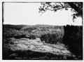
 c.1910
 -
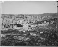
 1899, Townsend Maccoun
 -
 early 20th century
 -
 Colorized photo, early 20th century
 -
 The Old City in 1910
 -
 A barrier dividing sections of the Old City
 -
![A net installed in the Old City to prevent garbage dropped by Israeli settlers into a Palestinian area.[50]](//upload.wikimedia.org/wikipedia/commons/thumb/b/b5/HebronOldCityTrash.jpg/80px-HebronOldCityTrash.jpg) A net installed in the Old City to prevent garbage dropped by Israeli settlers into a Palestinian area.[50]
A net installed in the Old City to prevent garbage dropped by Israeli settlers into a Palestinian area.[50]


![A net installed in the Old City to prevent garbage dropped by Israeli settlers into a Palestinian area.[50]](http://upload.wikimedia.org/wikipedia/commons/thumb/b/b5/HebronOldCityTrash.jpg/80px-HebronOldCityTrash.jpg)
See also edit
References edit
- ^ Centre, UNESCO World Heritage. "Hebron/Al-Khalil Old Town". UNESCO World Heritage Centre. Retrieved 2022-12-23.
- ^ Jericke 2003, p. 17: "Spätestens in römischer Zeit ist die Ansiedlung im Tal beim heutigen Stadtzentrum zu finden Zwischen beiden Fundstellen, am Ostfuß des Gebel erRuméde, liegt die für die Wasserversorgung der Stadt wichtige Quelle Ain el-Guděde"
- ^ Achim Lichtenberger, Juden, Idumäer und „Heiden“. Die herodianischen Bauten in Hebron und Mamre, in: L.- M. Günther (ed.), Herodes und Rom (Stuttgart 2007), p.59: "Die hellenistisch-römische Stadt lag im Tal dazwischen"
- ^ Shahin & Bert Geith 2017, p. 54.
- ^ Shahin & Bert Geith 2017, p. 19: "Soon after the first Islamic Period (Umayyad Period), Al-Ibrahimi Mosque/The Tomb of Patriarchs became the focal point around which the town was built and strongly influenced its development, similar to the Haram al-Sharif in Jerusalem. Today, the historic town centre is dominated by the Mamluk architecture style built between 1250 and 1517... Mamluk architecture is predominant in Hebron/Al-Khalil’s historic centre. The urban fabric (street network and quarters), the ahwash (living units), the public buildings, the souks and the traditional way of life still retain the original spirit of the town. Most of the public and religious buildings that are still intact date back to this period. They are lavishly decorated with ornamental motifs such as muqarnas (stalactites or alveoles), ablaq (inlaid coloured marble panels), monumental inscriptions, etc."
- ^ UNESCO Nomination Executive Summary: "The existing urban structure dates back to the Mamluk period... The boundaries of the proposed site correspond to the boundaries of the continuous fabric of Hebron/Al-Khalil Town during the Mamluk Period... Since the Mamluk era, the morphological configration of the old town and the spatial organisation of the urban fabric have remained mostly- unchanged, and the main distinctive attributes have been retained."
- ^ Vitullo 2003, p. 68.
- ^ PEF Survey, volume III, p.305
- ^ Unesco Declares Hebron’s Core as Palestinian World Heritage Site
- ^ Decision : 41 COM 8C.1 Update of the List of World Heritage in Danger (Inscribed Properties)
- ^ "Protocol Concerning the Redeployment in Hebron". United Nations Information System on the Question of Palestine. Non-UN document. January 17, 1997. Archived from the original on October 24, 2007.
- ^ a b "Israeli NGO issues damning report on situation in Hebron". Agence France-Presse. ReliefWeb. August 19, 2003. Archived from the original on 2007-10-21.
- ^ "Hebron, Area H-2: Settlements Cause Mass Departure of Palestinians" (PDF). B'Tselem. August 2003. "In total, 169 families lived on the three streets in September 2000, when the intifada began. Since then, seventy-three families—forty-three percent—have left their homes."
- ^ "Palestine Refugees: a challenge for the International Community". United Nations Relief and Works Agency for Palestine Refugees in the Near East. ReliefWeb. October 10, 2006. Archived from the original on October 17, 2006.
Settler violence has forced out over half the Palestinian population in some neighborhoods in the downtown area of Hebron. This once bustling community is now eerily deserted, and presents a harrowing existence for those few Palestinians who dare to remain or who are too deep in poverty to move elsewhere.
- ^ a b "Ghost Town: Israel's Separation Policy and Forced Eviction of Palestinians from the Center of Hebron". B'Tselem. May 2007.
- ^ A ghost city revived: the remarkable transformation of Hebron
- ^ "Israeli police report reveals truth about expulsion of observers in Hebron". MEMO. December 21, 2019. Retrieved March 7, 2020.
- ^ "Confidential 20-year monitoring report: Israel regularly breaks int'l law in Hebron". haaretz.com. 2018-12-17. Retrieved 2018-12-17.
- ^ Dumper 2007, pp. 164–167.
- ^ Schick, 1898, p.238
- ^ Auerbach, Jerold S. (16 July 2009). Hebron Jews: Memory and Conflict in the Land of Israel. Rowman & Littlefield Publishers. pp. 110–. ISBN 978-0-7425-6617-0.
- ^ Neuman 2018, p. 3.
- ^ PEF Survey of Palestine, volume III, p.306: "The place is divided into three principal divisions: 1st, including the Haret el Haram (or el Kulah) and Haret Bab er Zawieh, the main part, with the Haram in the centre; 2nd, Haret esh Sheikh, so called from the mosque of Sheikh 'Aly Bukka, which is in it ; 3rd, Haret el Mesherky, which is towards the east, on the west side of the main road. The town extends for 3/4 mile parallel to the valley. The houses are well built of stone, with flat roofs having domes in the middle. The most prominent object is the Haram enclosure, standing over the houses. The mosque within and the upper portion of the great enclosing wall were newly whitewashed in 1874, and presented a very dazzling appearance. Since 1875 the town has grown, so that these various quarters are almost connected, and the Jews' quarter especially has been enlarged. To the four quarters named above must be added six others, viz., Haret el Kezazin, the Jews' quarter, north-west of the Haram ; Haret Beni Dar, just west of the Haram; Haret el 'Akkabeh and Haret el Kerad, on the hill behind the Haram ; Haret el Muhtcsbin, south-east of the Haram and of the great pool; and Haret es Suwakineh, north of the Haram, east of the Jews' quarter."
- ^ Biblical Researches in Palestine, volume II, p.446: "The Jewish dwellings are in the N.W. part of the main quarter of the town".
- ^ "Maan News Agency: Hebron road renamed "Apartheid Street"". 2011-11-02. Archived from the original on 2011-11-02. Retrieved 2023-01-08.
- ^ "B'Tselem – Press Releases – 31 Dec. 2007: B'Tselem: 131 Palestinians who did not participate in the hostilities killed by Israel's security forces in 2007". Btselem.org. 2007-12-31. Retrieved 2009-11-12.
- ^ "Israeli NGO issues damning report on situation in Hebron". Agence France-Presse. ReliefWeb. August 19, 2003. Archived from the original on October 21, 2007. Retrieved March 30, 2007.
- ^ "Hebron, Area H-2: Settlements Cause Mass Departure of Palestinians" (PDF). B'Tselem. August 2003. "In total, 169 families lived on the three streets in September 2000, when the intifada began. Since then, seventy-three families—forty-three percent—have left their homes."
- ^ "Palestine Refugees: a challenge for the International Community". United Nations Relief and Works Agency for Palestine Refugees in the Near East. ReliefWeb. October 10, 2006. Archived from the original on October 17, 2006.
Settler violence has forced out over half the Palestinian population in some neighborhoods in the downtown area of Hebron. This once bustling community is now eerily deserted, and presents a harrowing existence for those few Palestinians who dare to remain or who are too deep in poverty to move elsewhere.
- ^ Janine Zacharia (March 8, 2010). "Letter from the West Bank: In Hebron, renovation of holy site sets off strife". The Washington Post.
- ^ Hope in Hebron. David Shulman, New York Review of Books, 22 March 2013:
″Those who still live on Shuhada Street can't enter their own homes from the street. Some use the rooftops to go in and out, climbing from one roof to another before issuing into adjacent homes or alleys. Some have cut gaping holes in the walls connecting their homes to other (often deserted) houses and thus pass through these buildings until they can exit into a lane outside or up a flight of stairs to a passageway on top of the old casba market. According to a survey conducted by the human-rights organization B’Tselem in 2007, 42 per cent of the Palestinian population in the city center of Hebron (area H2)—some 1,014 families—have abandoned their homes and moved out, most of them to area H1, now under Palestinian control.″ - ^ The laws originated in H.R. 2145 and S. 875; for further details see committee discussions at: United States. Congress. House. Committee on Foreign Affairs. Subcommittee on Human Rights and International Organizations (1989). The PLO's Efforts to Obtain Statehood Status at the World Health Organization and Other International Organizations: Hearing and Markup Before the Subcommittee on Human Rights and International Organizations of the Committee on Foreign Affairs, House of Representatives, One Hundred First Congress, First Session, on H.R. 2145, May 4, 1989. U.S. Government Printing Office.. The text of the House and Senate resolutions were subsequently put into the following laws: H.R. 3743 (which produced Pub. L. 101–246), H.R. 5368, H.R. 2295 and finally H.R. 2333 (which produced Pub. L. 103–236). See also: Beattie, Kirk (3 May 2016). Congress and the Shaping of the Middle East. Seven Stories Press. p. 287 online. ISBN 978-1-60980-562-3.
...1989 Senate and House efforts like... Senate Resolution 875 and House Resolution 2145, both of which contained language similar to that found in the public laws of 1990 and 1994. Sen. Robert Kasten, Jr. (R-Wl) was the primary sponsor of S 875, and Rep. Tom Lantos sponsored HR 2145. In a nutshell, recognition by any UN body of the Palestinians' right to statehood or their achievement of statehood status would trigger a suspension of US funding to the "offending" UN body under these laws. (I'll just note in passing that it was Sen. Kasten who was to be a major recipient of campaign funds that AIPAC's President David Steiner was soliciting from one Haim Katz. Katz surreptitiously taped and released to the public the conversation, much to AIPAC's embarrassment. The conversation can be found on-line and makes for an interesting read.)
- ^ "U.S. stops UNESCO funding over Palestinian vote". Reuters. October 31, 2011. Retrieved February 26, 2020.
- ^ Shadi Sakran (26 November 2019). The Legal Consequences of Limited Statehood: Palestine in Multilateral Frameworks. Taylor & Francis. pp. 64–. ISBN 978-1-00-076357-7.
- ^ Request for the admission of the State of Palestine to UNESCO as a Member State, UNESCO Executive Board, 131st, 1989
- ^ a b "U.S., Israel quit U.N. heritage agency citing bias". Reuters. October 12, 2017. Retrieved February 26, 2020.
- ^ "Palestine: UNESCO Votes the Old City of Hebron a World Heritage Site". ARCP. July 2017. Archived from the original on November 10, 2020. Retrieved March 7, 2020.
- ^ "U.S., Israel quit U.N. heritage agency citing bias". Times of Israel. June 25, 2017. Retrieved February 26, 2020.
- ^ "UNESCO experts: Hebron heritage request too focused on Muslim history". Jerusalem Post. July 2, 2017. Retrieved March 8, 2020.
- ^ Lynn Meskell (1 June 2018). A Future in Ruins: UNESCO, World Heritage, and the Dream of Peace. Oxford University Press. pp. 196–. ISBN 978-0-19-064836-7.
- ^ ICOMOS: Hebron/Al-Khalil Old town (Palestine) No 1565, page 10
- ^ "There's nothing anti-Semitic about UNESCO's Hebron vote". +972 Magazine. July 9, 2017. Retrieved February 26, 2020.
- ^ https://unesdoc.unesco.org/in/rest/annotationSVC/DownloadWatermarkedAttachment/attach_import_e3fbd099-269a-433d-994d-84b71c739c1f?_=248900eng.pdf&to=56&from=1#pdfjs.action=download, Section 30.III, "Reaffirms that the two concerned sites located in Al-Khalil/Hebron and in Bethlehem are an integral part of the Occupied Palestinian Territory, and shares the conviction affirmed by the international community that the two sites are of religious significance for Judaism, Christianity and Islam;"
- ^ 2017 Nomination Text p.19: "As a pilgrimage site for the three monotheistic religions – Judaism, Christianity and Islam"; p.25: "The quarters defined by the community’s religion, such as the Christian quarter (harat al-Nasara, mentioned by Mujir al-Din) and the Jewish quarter (harat al-Yahud, mentioned in the 16th century Ottoman tax registers and by the Jewish travellers dur- ing the same period), or the bothare, which is no longer existing."; p.59: "Jewish families living in Hebron left the city after the eruption of violence in 1929 and mainly after 1948 war."
- ^ Ahren, Raphael; Agencies. "At stormy meet, UNESCO declares Hebron an endangered Palestinian site". Times of Israel. Retrieved 2020-02-25.
- ^ Rosenfeld, Alvin H. (2019-01-09). Anti-Zionism and Antisemitism: The Dynamics of Delegitimization. Indiana University Press. ISBN 978-0-253-03872-2.
- ^ "US slams Israel over designating heritage sites". Haaretz. 2010-02-25.
- ^ Gori, Maja. (2013). "The Stones of Contention: The Role of Archaeological Heritage in Israeli–Palestinian Conflict." Archaeologies. 9. 10.1007/s11759-013-9222-7. p.222
- ^ "Why Did the U.S. And Israel Leave UNESCO?". E-International Relations. February 14, 2019. Retrieved February 26, 2020.
- ^ Ward, Hazel (May 23, 2011). "West Bank B&B in Hebron's Old City fully booked". The Australian. Archived from the original on 2012-09-12. Retrieved November 18, 2022.
Notes edit
- ^ The ICOMOS report stated that:
ICOMOS considers that the property is under threat as a result of a long-standing and complex Israeli-Palestinian political situation. Restrictions have been in force in the old town since 1967 and these were intensified in 1994 and following the Oslo Accords. As well as leading to boundary walls, new roads and the construction of two settlements within the property, some demolition have taken place and conservation has been hindered. Moreover, the restrictions on free movement and the transfer of services to the periphery have had the effect of encouraging outward migration from the old town, although this is now slowly being reversed.[41]
Further reading edit
- Gish, Arthur G. (20 December 2018). Hebron Journal: Stories of Nonviolent Peacemaking. Wipf and Stock Publishers. ISBN 978-1-5326-6213-3.
- Shaheen, Wael (18 July 2018). "Israeli Settlements in the Old City of Hebron". In G Passerini (ed.). Islamic Heritage Architecture and Art II. WIT Press. ISBN 978-1-78466-251-6.
- Neuman, Tamara (June 2018). Settling Hebron: Jewish Fundamentalism in a Palestinian City. University of Pennsylvania Press. ISBN 978-0-8122-4995-8.
- Menachem Klein (2014). Lives in Common: Arabs and Jews in Jerusalem, Jaffa and Hebron. Oxford University Press. ISBN 978-0-19-939626-9.
- Vitullo, Anita (2003). "People Tied to Place: Strengthening Cultural Identity in Hebron's Old City". Journal of Palestine Studies. 33 (1): 68–83. doi:10.1525/jps.2003.33.1.68. JSTOR 10.1525/jps.2003.33.1.68.
- Conrad Schick (1898) Hebron and its Neighbourhood, Palestine Exploration Quarterly, 30:4, 232-238, DOI: 10.1179/peq.1898.30.4.232
- Dumper, Michael (2007). "Hebron". Cities of the Middle East and North Africa: A Historical Encyclopedia. ABC-CLIO. pp. 164–167. ISBN 978-1-57607-919-5.
- Jericke, Detlef (2003). Abraham in Mamre: Historische und exegetische Studien zur Region von Hebron und zu Genesis 11, 27 – 19, 38. BRILL. ISBN 978-90-04-12939-9. Retrieved 26 July 2011.
- Shahin, Alaa; Bert Geith, Sandrine (2017), UNESCO Nomination Document of Al-Khalil - Hebron Old Town, vol. Book 1
- Sharon, Moshe (13 December 2013). Corpus Inscriptionum Arabicarum Palaestinae, Volume Five: H-I. BRILL. ISBN 978-90-04-25481-7.
External links edit
- UNESCO, State of Conservation Reporting
- Hebron/Al-Khalil Old Town
- Hebron Rehabilitation Committee, Old City Archived 2021-08-16 at the Wayback Machine
- Khaled Osaily, Background to Nomination
- The U.S. Has Left UNESCO Before