
KNOWPIA
WELCOME TO KNOWPIA

Oldetrijne 
Summary
Oldetrijne (West Frisian: Aldetrine) is a village in Weststellingwerf in the province of Friesland, the Netherlands. It had a population of around 210 in 2017.[3]
Oldetrijne | |
|---|---|
Village | |
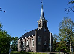 Church of Oldetrijne | |
 Location in Weststellingwerf municipality | |
 Oldetrijne Location in the Netherlands  Oldetrijne Oldetrijne (Netherlands) | |
| Coordinates: 52°51′43″N 5°56′46″E / 52.86194°N 5.94611°E | |
| Country | |
| Province | |
| Municipality | |
| Area | |
| • Total | 9.89 km2 (3.82 sq mi) |
| Elevation | 0.2 m (0.7 ft) |
| Population (2021)[1] | |
| • Total | 215 |
| • Density | 22/km2 (56/sq mi) |
| Postal code | 8479[1] |
| Dialing code | 0561 |
The village was first mentioned in 1320 as Ostrinde, and means "old border line". Olde (old) has been added to distinguish from Nijetrijne.[4] Oldetrijne is a road village which developed along the Schoterzijl to Wolvega road. The Dutch Reformed church dates from 1870.[5] In 1979, the church is also in use as the village house.[6]
Oldetrijne was home to 265 people in 1840.[6]
Gallery edit
-
 Bicycle bridge
 -
 Panorama of Oldetrijne

References edit
- ^ a b c "Kerncijfers wijken en buurten 2021". Central Bureau of Statistics. Retrieved 2 April 2022.
- ^ "Postcodetool for 8479HG". Actueel Hoogtebestand Nederland (in Dutch). Het Waterschapshuis. Retrieved 2 April 2022.
- ^ Villages - Weststellingwerf municipality (in Dutch)
- ^ "Oldetrijne". Etymologiebank (in Dutch). Retrieved 2 April 2022.
- ^ Ronald Stenvert & Sabine Broekhoven (2000). "Oldetrijne" (in Dutch). Zwolle: Waanders. ISBN 90 400 9476 4. Retrieved 2 April 2022.
- ^ a b "Oldetrijne". Plaatsengids (in Dutch). Retrieved 2 April 2022.
External links edit
![]() Media related to Oldetrijne at Wikimedia Commons
Media related to Oldetrijne at Wikimedia Commons