
KNOWPIA
WELCOME TO KNOWPIA

Olmstead Place State Park 
Summary
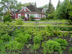
Olmstead Place State Park is a 217-acre (88 ha) Washington state park that preserves a working pioneer farm in Kittitas County. Park activities include picnicking, hiking, fishing, interpretive activities, wildlife viewing, and touring the living farm museum.[2] The park was added to the National Register of Historic Places in 1971.[3]
| Olmstead Place State Park | |
|---|---|
 | |
 Location in the state of Washington  Olmstead Place State Park (the United States) | |
| Location | Kittitas, Washington, United States |
| Coordinates | 46°58′13″N 120°28′19″W / 46.97028°N 120.47194°W[1] |
| Area | 217 acres (88 ha) |
| Elevation | 1,539 ft (469 m)[1] |
| Established | 1875[2] |
| Operator | Washington State Parks and Recreation Commission |
| Website | Olmstead Place State Park |
Olmstead Place State Park | |
| Location | 4 mi. east of Ellensburg near the Kittitas Hwy., Ellensburg, Kittitas County, Washington |
| Nearest city | Ellensburg, Washington |
| Area | 219 acres (89 ha) |
| NRHP reference No. | 71000878 |
| Added to NRHP | March 31, 1971 |
References edit
- ^ a b "Olmstead Place State Park". Geographic Names Information System. United States Geological Survey, United States Department of the Interior.
- ^ a b "Olmstead Place State Park". Washington State Parks and Recreation Commission. Retrieved February 18, 2016.
- ^ Ralph H. Rudeen, Chief of Interpretive Services (December 2, 1970). "National Register of Historic Places Registration Form: Olmstead Place State Park". National Park Service. Retrieved February 18, 2016.
External links edit
- Olmstead Place State Park Washington State Parks and Recreation Commission
- Olmstead Place State Park Map Washington State Parks and Recreation Commission