


Summary
Onekotan (Russian: Онекотан; Japanese 温禰古丹島; Onekotan-tō, occasionally Onnekotan-tō, Ainu: オネコタン or オネコタㇴ) is an uninhabited volcanic island located near the northern end of the Kuril Islands chain in the Sea of Okhotsk in the northwest Pacific Ocean. Its name is derived from the Ainu language for "large village”. It is the second largest island, after Paramushir, in the northern subgroup of the Kurils. It is administratively included in the Severo-Kurilsky District of Sakhalin oblast, Russia.
Native name: Онекотан 温禰古丹島 | |||||||||||||||||||||||||||||||||||||||||||||||||||||||||||||||||||||||||||||||||||||
|---|---|---|---|---|---|---|---|---|---|---|---|---|---|---|---|---|---|---|---|---|---|---|---|---|---|---|---|---|---|---|---|---|---|---|---|---|---|---|---|---|---|---|---|---|---|---|---|---|---|---|---|---|---|---|---|---|---|---|---|---|---|---|---|---|---|---|---|---|---|---|---|---|---|---|---|---|---|---|---|---|---|---|---|---|---|
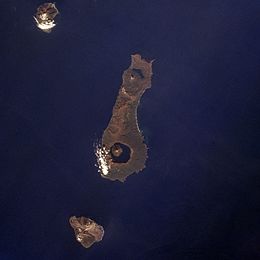 Onekotan Island (centre) from space, October 1994. North at top | |||||||||||||||||||||||||||||||||||||||||||||||||||||||||||||||||||||||||||||||||||||
 | |||||||||||||||||||||||||||||||||||||||||||||||||||||||||||||||||||||||||||||||||||||
 Onekotan | |||||||||||||||||||||||||||||||||||||||||||||||||||||||||||||||||||||||||||||||||||||
| Geography | |||||||||||||||||||||||||||||||||||||||||||||||||||||||||||||||||||||||||||||||||||||
| Location | Sea of Okhotsk | ||||||||||||||||||||||||||||||||||||||||||||||||||||||||||||||||||||||||||||||||||||
| Coordinates | 49°27′N 154°46′E / 49.450°N 154.767°E | ||||||||||||||||||||||||||||||||||||||||||||||||||||||||||||||||||||||||||||||||||||
| Archipelago | Kuril Islands | ||||||||||||||||||||||||||||||||||||||||||||||||||||||||||||||||||||||||||||||||||||
| Area | 425 km2 (164 sq mi) | ||||||||||||||||||||||||||||||||||||||||||||||||||||||||||||||||||||||||||||||||||||
| Highest elevation | 1,324 m (4344 ft) | ||||||||||||||||||||||||||||||||||||||||||||||||||||||||||||||||||||||||||||||||||||
| Highest point | Krenitsyn | ||||||||||||||||||||||||||||||||||||||||||||||||||||||||||||||||||||||||||||||||||||
| Administration | |||||||||||||||||||||||||||||||||||||||||||||||||||||||||||||||||||||||||||||||||||||
Russia | |||||||||||||||||||||||||||||||||||||||||||||||||||||||||||||||||||||||||||||||||||||
| Demographics | |||||||||||||||||||||||||||||||||||||||||||||||||||||||||||||||||||||||||||||||||||||
| Population | 0 | ||||||||||||||||||||||||||||||||||||||||||||||||||||||||||||||||||||||||||||||||||||
| Ethnic groups | Ainu (formerly) | ||||||||||||||||||||||||||||||||||||||||||||||||||||||||||||||||||||||||||||||||||||
|
Geography and geology
edit
Onekotan is roughly rectangular, with a length of 42.5 kilometers (26.4 mi), and a width ranging from 11 to 17 kilometers (6.8 to 10.6 mi). It has an area of 425 square kilometers (164 sq mi) [1]  The island consists of two stratovolcanos connected by a relatively flat isthmus.
The contemporary structure of the caldera basin of Koltsevoe Lake was examined by Kozlov et al.[3]through sonar survey utilizing a digital sonar and satellite positioning. The survey yielded 27 sonar profiles and a compiled bathymetric map. Presently, the lake holds the fourth position among Russia's deepest lakes, standing as the deepest in the Russian Far East and the largest in the Sakhalin region. Its significant water volume underscores its importance as a vital hydrological asset in the Far Eastern macro-region.  There are seven rivers on the island more than five kilometers long. The largest is Ozernaya River (8 kilometers (5.0 mi) long, which flows from the southern part of the caldera of the Nemo volcano to the Sea of Okhotsk. Almost the same length is the Kedrovka River, which flows from the central part of the island into the Pacific Ocean. The climate of Onekotan is characterized by short, cool summers, high humidity, frequent fogs, and especially strong winds. However, the island's climate is generally considered to be mild oceanic with an average annual temperature of about 4.0 °C (39.2 °F). Even in record cold winters, temperatures below −15 °C (5 °F) were not observed. Onekotan is separated from the neighboring islands by the Fourth Kuril Strait, Yevreinov Strait, and Krenitsyn Strait. The neighboring islands are Makanrushi, with a 1,170-meter (3,840 ft) volcanic peak, is 28 kilometers (17 mi) to the northwest of Onekotan; and Kharimkotan, with a 1,210-meter (3,970 ft) high volcano, is 15 kilometers (9.3 mi) to the southwest. Paramushir is located 53 kilometers (33 mi) to the northeast. Onekotan still has an active volcano with the most recent eruption, in 1952, forming a small lava dome on the island's coast. A bay on the eastern shore contains the remains of an abandoned settlement.
Climate edit
History editOnekotan, with a number of shallow bays and sandy beaching providing landing points, was inhabited by the Ainu prior to European contact. It appears on an official map showing the territories of Matsumae Domain, a feudal domain of Edo period Japan dated 1644, and these holdings were officially confirmed by the Tokugawa shogunate in 1715. The island was surveyed by Russian geodesists and explorers Ivan Yevreinov and Fyodor Luzhin in 1720, and was subsequently, claimed by the Empire of Russia in 1736 after the Ainu inhabitants were converted to the Russian Orthodox Church; however Russian tax collectors encountered Japanese officials on the islands in 1744–45. Sovereignty initially passed to Russia under the terms of the 1855 Treaty of Shimoda, but was returned to the Empire of Japan per the Treaty of Saint Petersburg in 1875 along with the rest of the Kuril islands. The island was formerly administered as part of Shimushu District of Nemuro Subprefecture of Hokkaidō. In 1884, the Ainu inhabitants were relocated by Japanese authorities to Shikotan. During World War II, the island had a small Japanese garrison, which surrendered on August 25, 1945, without a fight. After 1945, the island came under the control of the Soviet Union, and is now administered as part of the Sakhalin Oblast of the Russian Federation. A small garrison on the island was withdrawn in 2005. Flora and fauna editThere are chars in Lake Chyornoye, one of the two lakes on Onekotan, located at the northern end of the island. In the spring and summer pigeon guillemot and Leach's storm petrel nest on the island.[4] Mammals found on the island include foxes and small rodents, with seals and sea lions on the coast. The strong winds and harsh climate limit the growth of trees to small thickets of Krummholz formations of Siberian dwarf pine with a maximum height of 2–4 meters, mostly in gullies. See also editNotes edit
Further reading edit
External links editWikimedia Commons has media related to Onekotan.
| |||||||||||||||||||||||||||||||||||||||||||||||||||||||||||||||||||||||||||||||||||||

