


Summary
King's Highway 69, commonly referred to as Highway 69, is a provincially maintained north–south highway in the central portion of the Canadian province of Ontario. In conjunction with Highway 400, it links Toronto with the city of Greater Sudbury at Highway 17, via Parry Sound. It is part of the Trans-Canada Highway and the National Highway System. From its southern terminus of Highway 559 at Carling, Highway 69 begins as Highway 400 narrows from a four-laned freeway to a two lane highway. It travels northerly for approximately 68 kilometres (42 mi) to south of the French River before widening back to a divided four lane freeway for approximately 64 kilometres (40 mi) into Sudbury. The final 6 kilometres (3.7 mi) of the route, connecting to Highway 17, is a five lane arterial road that will be converted to freeway as the final phase of the four-laning.
Highway 69 | |||||||
|---|---|---|---|---|---|---|---|
| Trans-Canada Highway | |||||||
 Highway 69 highlighted in red | |||||||
| Route information | |||||||
| Maintained by The Ministry of Transportation of Ontario | |||||||
| Length | 140.3 km[1] (87.2 mi) | ||||||
| Existed | August 5, 1936[2]–present | ||||||
| Major junctions | |||||||
| South end | |||||||
| North end | |||||||
| Location | |||||||
| Country | Canada | ||||||
| Province | Ontario | ||||||
| Highway system | |||||||
| |||||||
| |||||||

Highway 69 was first designated in 1936 when the Department of Highways (DHO) assumed the Rama Road between Atherley and Washago. This short route was extended the following year when the DHO merged with the Department of Northern Development and expanded the King's Highway network north of the Severn River. By the beginning of World War II, the route reached as far north as Britt; a separate segment connected the town of Burwash with Sudbury. However, the rationing of labour and materials due to the war effort resulted in these two sections remaining separated until the mid-1950s. In 1976, several reroutings and renumbering took place in the Muskoka area. As a result, the portion of Highway 69 between Brechin and Foot's Bay was renumbered as Highway 169, while the entirety of Highway 103 between Coldwater and Foot's Bay was renumbered as Highway 69.
Between 1956 and 1979, Highway 69 extended through and north of Sudbury. Until some point between 1974 and 1977, it reached as far north as Capreol, after which it was truncated at Hanmer. By 1980, the northern terminus had shifted to the Southwest Bypass, onto which Highway 17 was rerouted in 1995. Throughout the 1990s and 2000s, Highway 400 was gradually pushed north to its current terminus by twinning Highway 69, gradually truncating its length. A commitment to complete four-laning to Sudbury has been made by all three major provincial political parties in Ontario since 1991, but as of 2022 there remains 70 kilometres (43 mi) of two lane highway still to be constructed. Various former alignments of Highway 69 remain in use as directional carriageways of Highway 400 or as local roads. The highway forms part of the Georgian Bay Route of the Trans-Canada Highway, which continues south along Highway 400.
Route description edit

Highway 69 is a major highway serving the recreational areas surrounding Georgian Bay and the Thirty Thousand Islands, as well as providing the westernmost fixed connection between southern and northern Ontario; the highway occupies the northern portion of a corridor that connects Toronto to Sudbury, with Highway 400 occupying the southern portion. While Highway 6 is located further west, it requires the use of a ferry service between the Bruce Peninsula and Manitoulin Island.[3][4]
Between Nobel and Sudbury, there are no large communities, although numerous small communities lie adjacent to the route, including the Shawanaga First Nation, Pointe au Baril, Magnetawan First Nation, Byng Inlet, Britt, Bigwood, Delamere and the Henvey Inlet First Nation.[5] As of 2023 the highway begins 1.0-kilometre (0.62 mi) north of Highway 559 (Exit 241) in Carling, where the divided four lane Highway 400 narrows into the two-laned Highway 69 (that will serve as the future southbound lanes).[1][6][7] Construction is scheduled to begin in the mid-2020s to extend Highway 400 northward by 11 kilometres (6.8 mi) from Highway 559 to Shebooshekong Road near the Shawanaga First Nation.[6]
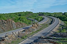
Highway 69 travels in a predominantly north-northeast direction, well inland of Georgian Bay. The Canadian Shield dominates the topography, resulting in numerous transverse marshes and rock outcroppings that bisect the highway, with dense forests in between;[7][8] services are limited and distant.[5][7] Exiting Carling Township, the highway enters The Archipelago, where it scrapes the northeastern edge of the Shawanaga First Nation. It provides access to Pointe au Baril and Pointe au Baril Station before intersecting the southern end of Highway 529, a former alignment of the highway.[9][10] It enters Unorganized Centre Parry Sound District, a sparsely-inhabited agglomeration of townships, where it provides access to Britt and Britt Station, as well as the northern end of Highway 529.[5][7]
Progressing north, Highway 69 enters Sudbury District at the community of Key River. It passes through Cranberry, intersecting Highway 522. Highway 69 widens to a four lane freeway north of Highway 522 before briefly curving northward. It crosses the French River near Wanikewin and encounters an interchange with Highway 607 near Bigwood. It remains a divided four-laned freeway the remainder of its journey into Sudbury, passing by the communities of Rutter, Burwash, Estaire, and Wanup before merging into a four-lane arterial road immediately southeast of Highway 17 at the Southeast Bypass. The highway ends at the interchange with Highway 17; past this point, the roadway continues into Sudbury as Municipal Road 46 (Regent Street).[5][7]
History edit
Highway 69 has undergone several major changes during its existence, so much so that the first section designated has not been a King's Highway for 60 years and lay approximately 80 km (50 mi) from the current highway. In other places, a minor two-lane gravel highway has gradually been upgraded to a four-lane freeway. On August 5, 1936, the DHO assumed the Rama Road, connecting Highway 12 at Atherley with Highway 11 at Washago.[2] On March 31, 1937, the Department of Northern Development (DND) was merged into the DHO, allowing the latter to extend the provincial highway network north of the Severn River.[11] Subsequently, through August 1937, Highway 69 was extended 77.75 mi (125.13 km) north to the Naiscoot River, midway between Pointe au Baril and Britt.[12][13] This extension followed DND trunk routes to Nobel, where a munitions and aircraft factory would soon provide an instrumental role in the war effort. In the north, the road connecting Sudbury and Burwash was also assumed as Highway 69 on August 11.[12] It was intended to connect these two segments over the next several years; however, the outbreak of World War II in September 1939 halted all non-essential construction due to the short supply of labour and materials.[14] Although an extension from the Naiscoot River to Britt would open by 1940.[15][16]
Once the war ended, construction resumed to bridge the 65 kilometres (40 mi) gap between the two sections of Highway 69.[17]French River and Alban would be linked to the provincial highway network via Britt by 1952. This allowed motorists to take a far more direct route between Severn River and Sudbury, by taking advantage of a detour via Highway 535 and Highway 64, through the small communities of Hagar and Noëlville.[18] That same year also saw the rerouting of the southern end of the highway; the southern end was moved east from Atherley to Brechin and the Rama Road decommissioned as a provincial highway. The new routing was longer but gave the southern end of the highway a more significant purpose than as a bypass of Highway 11. The Rama Road has since been known as Simcoe County Road 44.[19][20]
The biggest gap that remained on Highway 69 was between Alban and Burwash, but this was eliminated from 1952 to 1955,[21][22] providing a third link from Southern Ontario to Northern Ontario (the other two being Highway 11 and Highway 17). Until Highway 69 was completed between Parry Sound and Sudbury, drivers travelling between Southern Ontario and Sudbury or Sault Ste. Marie had to travel along a circuitous routing via Highway 11 to North Bay, and thence along Highway 17 to Sudbury and beyond to Sault Ste. Marie.[20] In 1956, Highway 69 was extended north of Sudbury to Capreol, bringing its length to 292.9 kilometres (182.0 mi).[23]
The year 1976 saw big changes for Highway 69. The portion of highway south of MacTier was shifted onto the routing of former Highway 103, completely absorbing that roadway into its length. The former routing was renamed Highway 169. It was at this time that Highway 69 was at its longest, from Highway 12 and Highway 400 at Waubaushene north to Sudbury.[24] Until the mid-1970s, Highway 69 continued through Sudbury along Regent Street, Paris Street and Notre Dame Avenue, and into the suburban towns of Valley East and Capreol. At some point between 1974 and 1977, it was truncated at Hanmer.[25][26] By 1980, the northern terminus had shifted to the Southwest Bypass.[27][28] While this route is no longer part of the provincial highway, and is officially designated as a series of Sudbury Municipal Roads, it is still often referred to locally as "Highway 69 North".[29]
Four-laning edit
Although planning for an eventual four-lane highway started in 1969, the commitment to expand the entirety of Highway 69 to a full freeway was first made in 1991 by the New Democrat government of Bob Rae.[31] The first work on the southernmost portion of the highway had already begun in 1990, with the construction of the southbound structures over Matchedash Bay and the Canadian National Railway crossing north of Highway 12. Both were complete by the end of 1990. During 1991, construction began on the interchanges at Quarry Road and Port Severn Road, new service roads between those interchanges and the southbound structure over the Trent–Severn Waterway. In 1988, the Ministry of Transportation of Ontario completed a study of the Highway 69 corridor between Muskoka Road 5 in Port Severn and Tower Road southwest of MacTier, a distance of approximately 45 km (28 mi). This work was carried out through the 1990s as one large project, reaching as far as south of Go Home Lake Road (Muskoka District Roads 32/38) by mid-to-late 1997.[32][33][34] It was extended 4 kilometres (2.5 mi) farther to south of the Musquash River in October 1999.[35] The Highway 400 designation was moved north, and Highway 69 equally shortened, after each project.[36][37]
Engineering was underway on the first 65 kilometres (40 mi) south of Sudbury. However, that project was shelved by the Progressive Conservative (PC) government of Mike Harris shortly after the 1995 provincial election.[38] Despite this, construction of the segment from Highway 141 to the Seguin River, proceeded in November 1999, and the MacTier bypass south of Highway 141 to the Moon River in February 2000. The majority of these three projects were built on a new alignment, with the former route of Highway 69 becoming Lake Joseph Road and Oastler Park Road.[39] Lake Joseph Road is maintained by the MTO as an unsigned highway. The portion south of Highway 141 designated as Highway 7289, and the northern portion as Highway 7290.[1] The Parry Sound Bypass, from Badger Road to the Seguin River, opened on November 1, 2001;[30] the section from Highway 141 to Badger Road opened in October 2002;[35] and the MacTier Bypass opened on October 7, 2003.[40]

The Highway 400 designation was extended northward from the Musquash River to the Seguin River following the opening of the MacTier Bypass, but the Highway 69 designation remained in place as a concurrency. This was due a 7.6-kilometre (4.7 mi) two lane gap between the Musquash and Moon Rivers, passing through the Wahta Mohawks territory, that came to be known as the Wahta Gap.[41][42] The Territorial Reserve did not oppose the construction; however, the land was unobtainable due to a technicality requiring a minimum voter turnout of 65 percent.[43] The land claim was settled by a vote held on October 25, 2003.[44] Following ratification, construction began in December 2004,[35] and opened July 15, 2008.[45] Following its completion, Highway 69 was truncated at what is now the south junction of Lake Joseph Road (Exit 189) near MacTier, an overall reduction of over 40 kilometres (24.9 mi) since prior to 1989.[36]
The City of Sudbury continued to lobby for the expansion of the highway, calling attention especially to an ongoing series of fatal car accidents at the intersection of Highway 637, where a sharp S-curve along Highway 69 rendered the approaching intersection effectively invisible to northbound traffic. Assisted by Rick Bartolucci, the Liberal MPP for Sudbury, the CRASH 69 (Community Rallying Against Substandard Highway 69) committee of Sudbury residents campaigned throughout the late 1990s and early 2000s to have the project reinstated.[31][46]
Premier Harris' successor (and former MPP for Parry Sound—Muskoka), Ernie Eves, announced the resumption of construction between Parry Sound and Sudbury in 2002; however, the PCs did not commit to four-laning the entire route.[31] The Liberal government of Dalton McGuinty came to power following the 2003 election with a promise to have a commitment in place within six months.[47] Construction began on a 20-kilometre (12 mi) segment south of Sudbury to Estaire in January 2005, with route planning studies now completed for the remaining two-lane sections.[48][49] In June of that year, construction began on a 16-kilometre (9.9 mi) extension of four-laning from Parry Sound to north of Nobel.[35] Later in 2005, the provincial government announced that four-laning between Parry Sound and Sudbury would be completed by 2017.[50]
The first project completed north of Parry Sound was the section between Sudbury and Estaire, which opened on November 12, 2009.[51] The section from south of the Seguin River in Parry Sound to north of Highway 559, bypassing Nobel, opened on October 26, 2010.[52] The former alignment in Sudbury is now known as Estaire Road,[53] while the former route through Nobel is now Nobel Road.[54] In 2008, work began to realign the S-curve at Highway 637; two lanes opened to traffic on July 27, 2010,[55] while the completed four-lane route, with an interchange at Highway 637, opened to traffic on August 8, 2012.[56] The former alignment now has the name Murdock River Road, and serves as a local road accessible only from Highway 637.[57] In the summer of 2012, the Highway 69 designation was shortened by 63.4 kilometres (39.4 mi), between MacTier and 1 kilometre north of Highway 559, resulting in its current length.[1][58][59]
Highway 69 passes through significant tracts of wilderness and forested land, and consequently has seen a rate of animal collisions well above the provincial norm. Several segments of the four-laned route will include special grade-separated wildlife crossings, the first of which was completed in March 2012.[60] In the summer of 2012, work began to four lane a 9-kilometre (5.6 mi) segment between north of Highway 64 and the Murdock River,[61] as well as on a 11-kilometre (6.8 mi) segment between Highway 607 and north of Highway 64.[62] The first project was opened September 11, 2015,[63] while the segment from north of Highway 607 to north of Highway 64, including an interchange at the latter, was opened by the beginning of August 2016.[64] The most recently completed section as of 2023 was a 14-kilometre (8.7 mi) segment from north of Highway 522 to north of Highway 607 that opened on December 23, 2021.[65]
Future edit
Although the original plan called for the four-laning of the highway to be complete by 2017, the timeline was pushed back due to delays in environmental assessments and land negotiations with First Nations bands impacted by the construction.[66] In the early 2010s, a widespread perception that the project appeared to be falling behind schedule was frequently discussed in Sudbury's media and by candidates in municipal and provincial elections,[67] but the Ministry of Transportation continued to assert that the project was on track for completion in 2017. In March 2015, the ministry officially acknowledged that the 2017 timeline would not be met, and indicated that the new target date was between 2019 and 2021.[66] In 2017, however, although the ministry made no formal announcement, its annual Northern Highways Report listed a completion date within that period only for the section already under construction between the French River and north of Highway 522 at Grundy Lake Provincial Park.[68] This section opened in December 2021, several months ahead of the originally foreseen completion date of 2022.[69]
The remaining route between Nobel and Grundy Lake is listed as "beyond 2021", as of July 2021.[70] A 19.3-kilometre (12.0 mi) section, from north of the Magnetawan River to Grundy Lake, is funded but has no announced construction timeline.[71]
Major intersections edit
The following table lists the major junctions along Highway 69, as noted by the Ministry of Transportation of Ontario.[1][36][72]
| Division | Location | km[1][36][72] | mi | Exit | Destinations | Notes |
|---|---|---|---|---|---|---|
| Simcoe | Waubaushene | −100.3 | −62.3 | 147 | Southern terminus of Highway 69 from 1976 until 1997[24][36][37] | |
| 149 | Tay Road 2 | |||||
| Port Severn | 153 | Port Severn Road South – Port Severn | ||||
| Muskoka | −91.8 | −57.0 | 156 | |||
| Georgian Bay | −83.5 | −51.9 | 162 | |||
| −79.0 | −49.1 | – | ||||
| 168 | Georgian Bay Road, Crooked Bay Road | |||||
| −72.8 | −45.2 | 174 | ||||
| −69.3– −70.0 | −43.1– −43.5 | – | Interchange opened in 2005 | |||
| −66.2 | −41.1 | – | Southern terminus of Highway 69 from 1999 until 2008[35] | |||
| – | Iroquois Cranberry Growers Drive – Wahta Mohawk Territory | |||||
| −61.7 | −38.3 | – | ||||
| −61.2 | −38.0 | – | Moon River crossing | |||
| −58.2 | −36.2 | 189 | Southern terminus of Highway 69 from 2008 to 2012, now known as Lake Joseph Road[35][58] | |||
| −53.8 | −33.4 | – | ||||
| Foot's Bay | −52.1 | −32.4 | – | Formerly Highway 169[37] | ||
| Parry Sound | Gordon Bay | −43.0 | −26.7 | – | ||
| Seguin | – | Beginning of Highway 141 concurrency (2003 - 2012)[59] | ||||
| −32.8 | −20.4 | – | End of Highway 141 concurrency (2003 - 2012); terminus of Highway 141 prior to 2003[36][59] | |||
| −30.2 | −18.8 | 213 | Beginning of Highway 400 concurrency (2003 - 2012)[59] | |||
| −27.1 | −16.8 | 214 | Seguin Trail, Horseshoe Lake Road | |||
| −23.9 | −14.9 | 217 | Oastler Park Drive, Badger Road | Former alignment of Highway 69 prior to 2003[37] | ||
| −20.5 | −12.7 | 220 | ||||
| Parry Sound | −16.9 | −10.5 | 224 | Bowes Street, McDougall Road | ||
| −14.4 | −8.9 | 229 | Parry Sound Drive | Former alignment of Highway 69[37] | ||
| McDougall | −11.8 | −7.3 | 231 | |||
| −1.3 | −0.81 | 241 | ||||
| Carling | 0.0 | 0.0 | – | Southern terminus of Highway 69; Highway 400 continues as a divided freeway | ||
| 17.2 | 10.7 | – | Shebeshekong Road | Unsigned Highway 7182[1] | ||
| Pointe Au Baril | 26.4 | 16.4 | – | |||
| The Archipelago | 28.3 | 17.6 | – | |||
| Magnetawan First Nation | 48.3 | 30.0 | – | |||
| Henvey | 53.5 | 33.2 | – | |||
| Cranberry | 66.3 | 41.2 | – | |||
| 70.0 | 43.5 | – | Beginning of divided freeway | |||
| French River 13 | 72.9 | 45.3 | – | Pickerel River Road / Settlers Road | Interchange opened December 23, 2021[65] | |
| Parry Sound-Sudbury boundary | Bon Air | 76.0 | 47.2 | – | French River bridge | |
| Sudbury | Bigwood | 80.5 | 50.0 | – | ||
| Rutter | 90.3 | 56.1 | – | Interchange opened August 2016[64] | ||
| Unorganized Sudbury District | 102.0 | 63.4 | – | Crooked Lake Road | Interchange opened September 11, 2015[63] | |
| 107.1 | 66.5 | – | Interchange opened August 8, 2012[56] | |||
| 119.1 | 74.0 | – | Nelson Road – Estaire | |||
| Greater Sudbury | 128.1 | 79.6 | – | |||
| 134.0 | 83.3 | – | Estaire Road | Former alignment of Highway 69[53] | ||
| 134.5 | 83.6 | – | End of divided freeway | |||
| 140.3 | 87.2 | – | Roadway continues northerly as Sudbury Municipal Road 46 (Regent Street) | |||
1.000 mi = 1.609 km; 1.000 km = 0.621 mi
| ||||||
References edit
- ^ a b c d e f Ministry of Transportation of Ontario (2016). "Annual Average Daily Traffic (AADT) counts". Retrieved January 1, 2021.
- ^ a b "Schedule 4 – Schedule of Assumptions and Reversions of Sections". Annual Report (Report). Department of Highways. February 23, 1938. p. 51. Retrieved August 31, 2021 – via Internet Archive.
- ^ "Background". Ministry of Transportation of Ontario. Archived from the original on June 8, 2011. Retrieved August 27, 2021.
- ^ Official Ontario Road Map (PDF) (Map). Cartography by Geomatics Office. 2020–2021. §§ L20–O25. Retrieved August 27, 2021.
- ^ a b c d Ontario Back Road Atlas (Map). Cartography by MapArt. Peter Heiler Ltd. 2010. pp. 56, 74–75, 92. §§ D19–Q26. ISBN 978-1-55198-226-7.
- ^ a b BayToday Staff (July 22, 2021). "More four-laning of Hwy 69 on the books under 2021 Ontario Highways Program". Sudbury.com. Retrieved August 27, 2021.
- ^ a b c d e Google (August 27, 2021). "Highway 69 – Length and Route" (Map). Google Maps. Google. Retrieved August 27, 2021.
- ^ "French River Provincial Park: A historic waterway through Canadian Shield gneiss; GeoTours Northern Ontario series" (PDF). Natural Resources Canada and Ontario Geological Survey. 2015. Retrieved August 30, 2021.
- ^ Ontario Road Map (Map). Cartography by C.P. Robins. Ontario Department of Highways. 1960. §§ O31–32.
- ^ Ontario Road Map (Map). Cartography by C.P. Robins. Ontario Department of Highways. 1961. §§ O31–32.
- ^ Shragge, John; Bagnato, Sharon (1984). From Footpaths to Freeways. Ontario Ministry of Transportation and Communications, Historical Committee. pp. 71–73. ISBN 0-7743-9388-2.
- ^ a b "Appendix No. 3 - Schedule of Assumptions and Reversions of Sections of the King's Highway System for the Year Ending March 31, 1938". Annual Report (Report). Department of Highways. April 20, 1939. p. 80. Retrieved August 31, 2021 – via Internet Archive.
- ^ "Division No. 12 - Parry Sound". Annual Report (Report). Department of Highways. October 26, 1939. p. 34. Retrieved August 31, 2021 – via Internet Archive.
- ^ Shragge, John G. (2007). "Highway 401: The Story". Archived from the original on March 28, 2008. Retrieved August 31, 2021.
- ^ Ontario Road Map (Map). Cartography by D. Barclay. Department of Highways. 1939–40. §§ J3–K4. Retrieved August 31, 2021.
- ^ Ontario Road Map (Map). Cartography by D. Barclay. Department of Highways. 1940–41. §§ J3–K4. Retrieved August 31, 2021.
- ^ "To Complete Sudbury Road". The Windsor Star. November 14, 1947. p. 19. Retrieved August 31, 2021.
- ^ Ontario Road Map (Map). Cartography by C. P. Robins. Department of Highways. 1952. §§ N31–O32. Retrieved August 31, 2021.
- ^ Ontario Road Map (Map). Cartography by C. P. Robins. Department of Highways. 1952. § Q34. Retrieved June 8, 2021 – via Archives of Ontario.
- ^ a b Ontario Road Map (Map). Cartography by C. P. Robins. Department of Highways. 1953. § Q34. Retrieved June 8, 2021 – via Archives of Ontario.
- ^ Ontario Road Map (Map). Cartography by C. P. Robins. Department of Highways. 1954. § N31. Retrieved August 31, 2021.
- ^ Ontario Road Map (Map). Cartography by C. P. Robins. Department of Highways. 1955. § N31. Retrieved August 31, 2021.
- ^ Ontario Road Map (Map). Cartography by C. P. Robins. Department of Highways. 1956. § M30–N31. Retrieved September 1, 2021 – via Archives of Ontario.
- ^ a b Public and Safety Information Branch (April 14, 1976). "Toronto–Sudbury Highways to be Renumbered" (Press release). Ministry of Transportation and Communications.
- ^ Ontario Road Map (Map). Cartography by Engineering Plans Office. Ministry of Transportation and Communications. 1974. §§ O–P13. Retrieved September 1, 2021 – via Archives of Ontario.
- ^ Ontario Road Map (Map). Cartography by Cartography Section. Ministry of Transportation and Communications. 1977. Regional Municipality of Sudbury inset. Retrieved September 1, 2021 – via Archives of Ontario.
- ^ Ontario Road Map (Map). Cartography by Cartography Section, Surveys and Plans Office. Ministry of Transportation and Communications. 1978–79. Regional Municipality of Sudbury inset. Retrieved December 13, 2021 – via Archives of Ontario.
- ^ Ontario Road Map (Map). Cartography by Cartography Section, Surveys and Plans Office. Ministry of Transportation and Communications. 1980–81. Regional Municipality of Sudbury inset. Retrieved December 13, 2021 – via Archives of Ontario.
- ^ Keown, Mary (August 10, 2018). "Cutting noise to Maley Drive neighbours would be costly: report". Sudbury Star. Retrieved August 15, 2021.
...the construction of a cloverleaf interchange at the intersection of Highway 69 North and the Maley Drive extension.
- ^ a b Ministry of Transportation of Ontario (2003). "Limits of Existing Four Laning". Government of Ontario. Archived from the original on February 15, 2003. Retrieved December 27, 2011.
- ^ a b c Ross, Ian (July 13, 2008). "Highway 69 and 11 expansion rolling north: Northerners say safety, efficiency, new development will open up the region". Northern Ontario Business. Retrieved August 14, 2021.
- ^ "Highway 400 & 69: From Coldwater to Port Severn". Provincial Highways Construction Projects 1989-90 (Report). Ministry of Transportation. May 1989. p. 14. ISSN 0714-1149.
- ^ "Highway 400 & 69: From Coldwater to Port Severn". Provincial Highways Construction Projects 1991-92 (Report). Ministry of Transportation. May 1991. p. 10. ISSN 0714-1149.
- ^ Canadian Press (July 9, 1997). "2 highways to north to be widened". Toronto Star. p. A10.
Highway 69 will have four lanes to 20 kilometres north of Port Severn by the end of the summer. Another 23 kilometres will be added, extending north to Parry Sound.
- ^ a b c d e f g Ministry of Transportation of Ontario (2005). "Status of Construction Activity". Government of Ontario. Archived from the original on November 19, 2005. Retrieved August 22, 2021.
- ^ a b c d e f "Provincial Highways Distance Table" (PDF). Provincial Highways Distance Table: King's Secondary Highways and Tertiary Roads. Ministry of Transportation of Ontario: 80. 1997. ISSN 0825-5350. Retrieved March 13, 2021 – via Legislative Assembly of Ontario.
- ^ a b c d e Ontario Road Map (Map). Cartography by Cartography Section. Ministry of Transportation. 1996. §§ E–F8. Retrieved August 23, 2021.
- ^ St. Pierre, Denis (October 3, 1999). "Four-laning is on the slow track". Sudbury Star. p. A1.
- ^ Ministry of Transportation of Ontario (2000). "Status of Construction Activity". Government of Ontario. Archived from the original on August 23, 2000. Retrieved August 22, 2021.
- ^ Ministry of Transportation of Ontario (October 7, 2003). "Notice of Opening of a New Four-Lane Highway Section of Highway 400". Government of Ontario. Archived from the original on December 27, 2003. Retrieved August 22, 2021.
- ^ de Souza, Raymond (December 17, 2020). "First Nations' Water Problems No Surprise". National Post. p. AS13. Retrieved August 22, 2021.
- ^ Moss, Peter (2010). Thriller: Ghosts of the Dark Sky Bogs and Barrens. Chapter 8: Wahta Mohawks. ISBN 978-0-557-89949-4. Retrieved August 22, 2021.
- ^ Ladan, Mark (February 20, 2002). "Land Claim Issues Leave Highway 400 Extension in Limbo". Government of Ontario. Archived from the original on May 12, 2012. Retrieved August 23, 2021.
- ^ Meeting No. PW-01-2004 - Engineering and Public Works Committee (Report). District Municipality of Muskoka. December 17, 2003. p. 30. Retrieved August 23, 2021.
I am very pleased to inform you that the Wahta Mohawks have ratified the final land claim settlement agreement through a community vote on October 25, 2003. A majority of eligible voters cast votes, and approximately 79% of voters were in favour of the agreement.
- ^ Tynan, Jack (July 17, 2008). "Highway 400 opens near MacTier". Huntsville Forester. Retrieved August 23, 2021.
- ^ "Hwy 69 completion date pushed back — again". Sudbury Star. August 17, 2017. Retrieved August 17, 2021.
- ^ Vaillancourt, Bob (November 4, 2004). "Work on highway starts slowly: Contract issued to widen 700 metres of Highway 69". Sudbury Star. p. A1.
- ^ "Contract awarded for widening of highway 69". Sault Star. December 18, 2004. p. A6.
- ^ Ministry of Transportation of Ontario (2006). "Status of Construction Activity". Government of Ontario. Archived from the original on December 19, 2006. Retrieved August 24, 2021.
- ^ St. Pierre, Denis (October 29, 2005). "Bad intersection to be fixed". Sudbury Star. p. A3.
[Paul] Lecoarer also provided city council with an update on the ministry's 12-year plan to complete the four-laning of Highway 69 between Sudbury and Parry Sound.
- ^ "New section of 69 opens to public". Sudbury.com. Northern Life. November 13, 2009. Retrieved August 14, 2021.
- ^ "$177-million section of highway now open". CottageCountryNow.ca. October 27, 2010. Archived from the original on July 26, 2011. Retrieved August 14, 2021.
- ^ a b Google (August 15, 2021). "Estaire Road" (Map). Google Maps. Google. Retrieved August 15, 2021.
- ^ Google (August 14, 2021). "Nobel Road" (Map). Google Maps. Google. Retrieved August 14, 2021.
- ^ "Bad section of Highway 69 now fixed: MPP". Sudbury Star. July 28, 2010. Archived from the original on March 6, 2012. Retrieved August 15, 2021.
- ^ a b Poliakov, Rita (August 4, 2012). "From tragedy to action -- more Hwy 69 4-laned". Sudbury Star. Archived from the original on August 13, 2014. Retrieved August 15, 2021.
- ^ Google (August 15, 2021). "Former Highway 69 S-curve – Murdock River Road at Highway 637" (Map). Google Maps. Google. Retrieved August 15, 2021.
- ^ a b Cooper, Cody Storm (June 27, 2012). "Highway 69 Name Change". Huntsville Forester. Metroland Media.
- ^ a b c d Ministry of Transportation of Ontario (2012). "Annual Average Daily Traffic (AADT) counts". Archived from the original on September 28, 2016. Retrieved January 1, 2021.
- ^ "Ontario builds first bridge for animals near Sudbury". CBC News. March 20, 2012. Retrieved August 15, 2021.
- ^ Ministry of Energy, Northern Development and Mines (August 3, 2012). "Another Highway 69 Expansion South Of Sudbury". Ontario Newsroom. Retrieved February 7, 2022.
- ^ Ministry of Energy, Northern Development and Mines (July 16, 2012). "Expanding Highway 69 South Of Sudbury". Ontario Newsroom. Retrieved February 7, 2022.
- ^ a b "Highway 69 a bit wider today". Sudbury Star. September 11, 2015. Retrieved August 26, 2021.
- ^ a b "Thibeault announces completion of Highway 69 widening". Sudbury.com. July 15, 2016. Retrieved September 7, 2021.
- ^ a b "Ontario Opens Newly Expanded Highway 69". Government of Ontario. December 23, 2021. Retrieved December 23, 2021.
- ^ a b Vaillancourt, Bob (November 4, 2014). "Highway 69 to be delayed, province admits". Sudbury Star. p. A1. Retrieved August 17, 2021.
- ^ Leeson, Ben (January 2, 2015). "Sudbury Accent: Highway 69 by 2017' Seems unlikely". Retrieved August 17, 2021.
- ^ "Hwy 69 completion date pushed back — again". Sudbury Star. August 16, 2017. Retrieved August 17, 2021.
- ^ "New section of road opens on Highway 69". Northern Ontario Business. December 23, 2021. Retrieved February 7, 2022.
- ^ BayToday Staff (July 22, 2021). "More four-laning of Hwy 69 on the books under 2021 Ontario Highways Program". Retrieved August 17, 2021.
- ^ Infrastructure Canada (May 21, 2019). "Major improvements to Highway 69 in Northern Ontario to support safer and more efficient travels". Canada Newswire. Retrieved August 30, 2021.
- ^ "Provincial Highways Distance Table". Provincial Highways Distance Table: King's Secondary Highways and Tertiary Roads. Ministry of Transportation of Ontario: 73. 1989. ISSN 0825-5350.
External links edit
- Highway 69 at OntHighways.com
- Highway 69 Four-Laning Detail Design
- Highway 69 Expansion - engineering and design projects