
KNOWPIA
WELCOME TO KNOWPIA

Oosterstreek 
Summary
Oosterstreek (West Frisian: Easterstreek) is a small village in Weststellingwerf in the province of Friesland, the Netherlands. It had a population of around 535 in 2017.[3]
Oosterstreek | |
|---|---|
Village | |
 | |
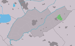 Location in Weststellingwerf municipality | |
 Oosterstreek Location in the Netherlands  Oosterstreek Oosterstreek (Netherlands) | |
| Coordinates: 52°53′57″N 6°10′9″E / 52.89917°N 6.16917°E | |
| Country | |
| Province | |
| Municipality | |
| Area | |
| • Total | 4.47 km2 (1.73 sq mi) |
| Elevation | 5 m (16 ft) |
| Population (2021)[1] | |
| • Total | 545 |
| • Density | 120/km2 (320/sq mi) |
| Postal code | 8388[1] |
| Dialing code | 0561 |
The village was first mentioned in 1974 as Oosterstreek, and is a new name for the linear settlement along the Noordwolde to Boijl road,[4] however it was first used around 1930 by the local football club. It means "eastern region" (as viewed from Noordwolde). The area around Oosterstreek was a peat excavation region, and nowadays mainly consists of heath.[5]
References edit
- ^ a b c "Kerncijfers wijken en buurten 2021". Central Bureau of Statistics. Retrieved 2 April 2022.
- ^ "Postcodetool for 8388MA". Actueel Hoogtebestand Nederland (in Dutch). Het Waterschapshuis. Retrieved 2 April 2022.
- ^ Villages - Weststellingwerf municipality (in Dutch)
- ^ "Oosterstreek - (geografische naam)". Etymologiebank (in Dutch). Retrieved 2 April 2022.
- ^ "Oosterstreek". Plaatsengids. Retrieved 2 April 2022.