
KNOWPIA
WELCOME TO KNOWPIA

Oosterzele 
Summary
Oosterzele (Dutch pronunciation: [ˈoːstərzeːlə]) is a municipality located in the Flemish province of East Flanders, in Belgium. The municipality comprises the towns of Balegem, Gijzenzele, Landskouter, Moortsele, Oosterzele proper and Scheldewindeke. In 2021, Oosterzele had a total population of 13,740. The total area is 43.12 km².[2] Its twin town is Oberkirch in Germany.
Oosterzele | |
|---|---|
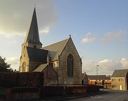 Church of Landskouter (2008) | |
 Flag  Coat of arms | |
Location of Oosterzele .mw-parser-output .locmap .od{position:absolute}.mw-parser-output .locmap .id{position:absolute;line-height:0}.mw-parser-output .locmap .l0{font-size:0;position:absolute}.mw-parser-output .locmap .pv{line-height:110%;position:absolute;text-align:center}.mw-parser-output .locmap .pl{line-height:110%;position:absolute;top:-0.75em;text-align:right}.mw-parser-output .locmap .pr{line-height:110%;position:absolute;top:-0.75em;text-align:left}.mw-parser-output .locmap .pv>div{display:inline;padding:1px}.mw-parser-output .locmap .pl>div{display:inline;padding:1px;float:right}.mw-parser-output .locmap .pr>div{display:inline;padding:1px;float:left}html.skin-theme-clientpref-night .mw-parser-output .od,html.skin-theme-clientpref-night .mw-parser-output .od .pv>div,html.skin-theme-clientpref-night .mw-parser-output .od .pl>div,html.skin-theme-clientpref-night .mw-parser-output .od .pr>div{background:#000;color:#fff}html.skin-theme-clientpref-night .mw-parser-output .locmap{filter:grayscale(0.6)}@media(prefers-color-scheme:dark){html.skin-theme-clientpref-os .mw-parser-output .locmap{filter:grayscale(0.6)}html.skin-theme-clientpref-os .mw-parser-output .od,html.skin-theme-clientpref-os .mw-parser-output .od .pv>div,html.skin-theme-clientpref-os .mw-parser-output .od .pl>div,html.skin-theme-clientpref-os .mw-parser-output .od .pr>div{background:#000;color:#fff}}  Oosterzele Location in Belgium
Location of Oosterzele in East Flanders 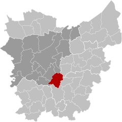 | |
| Coordinates: 50°57′N 03°48′E / 50.950°N 3.800°E | |
| Country | |
| Community | Flemish Community |
| Region | Flemish Region |
| Province | East Flanders |
| Arrondissement | Ghent |
| Government | |
| • Mayor | Johan Van Durme (CD&V) |
| • Governing party/ies | CD&V/N-VA |
| Area | |
| • Total | 43.57 km2 (16.82 sq mi) |
| Population (2018-01-01)[1] | |
| • Total | 13,546 |
| • Density | 310/km2 (810/sq mi) |
| Postal codes | 9860 |
| NIS code | 44052 |
| Area codes | 09 |
| Website | www.oosterzele.be |
Geography edit
Oosterzele is subdivided into 6 sub-municipalities:
| # | Deelgemeentes | Area (km²) | Population | Population density |
|---|---|---|---|---|
| I | Oosterzele | |||
| II | Balegem | 12,02 | ||
| III | Scheldewindeke | 11,84 | ||
| IV | Moortsele | 3,64 | ||
| V | Landskouter | |||
| VI | Gijzenzele | 1,87 |

Famous inhabitants edit
- Els De Temmerman, journalist, activist
- Johan Van Hecke, politician
- Gustaaf Joos, Roman Catholic cardinal
- Frans Van De Velde (1909-2002), missionary
- Gerard Vekeman (1933), poet
- Walter Muls (1961), politician
- Tom De Sutter (1985), football player
- Johan Taeldeman, linguist, dialectologist, professor-emeritus UGent
References edit
External links edit
 Media related to Oosterzele at Wikimedia Commons
- (in Dutch) Official website (in Dutch)