


Summary
Oradour-sur-Glane (French pronunciation: [ɔʁaduʁ syʁ ɡlan]; Occitan: Orador de Glana) is a commune in the Haute-Vienne department, New Aquitaine, west central France, as well as the name of the main village within the commune.
Oradour-sur-Glane
Orador de Glana (Occitan) | |
|---|---|
 Oradour-sur-Glane Town Hall | |
 Coat of arms | |
Location of Oradour-sur-Glane .mw-parser-output .locmap .od{position:absolute}.mw-parser-output .locmap .id{position:absolute;line-height:0}.mw-parser-output .locmap .l0{font-size:0;position:absolute}.mw-parser-output .locmap .pv{line-height:110%;position:absolute;text-align:center}.mw-parser-output .locmap .pl{line-height:110%;position:absolute;top:-0.75em;text-align:right}.mw-parser-output .locmap .pr{line-height:110%;position:absolute;top:-0.75em;text-align:left}.mw-parser-output .locmap .pv>div{display:inline;padding:1px}.mw-parser-output .locmap .pl>div{display:inline;padding:1px;float:right}.mw-parser-output .locmap .pr>div{display:inline;padding:1px;float:left}html.skin-theme-clientpref-night .mw-parser-output .od,html.skin-theme-clientpref-night .mw-parser-output .od .pv>div,html.skin-theme-clientpref-night .mw-parser-output .od .pl>div,html.skin-theme-clientpref-night .mw-parser-output .od .pr>div{background:#000;color:#fff}html.skin-theme-clientpref-night .mw-parser-output .locmap{filter:grayscale(0.6)}@media(prefers-color-scheme:dark){html.skin-theme-clientpref-os .mw-parser-output .locmap{filter:grayscale(0.6)}html.skin-theme-clientpref-os .mw-parser-output .od,html.skin-theme-clientpref-os .mw-parser-output .od .pv>div,html.skin-theme-clientpref-os .mw-parser-output .od .pl>div,html.skin-theme-clientpref-os .mw-parser-output .od .pr>div{background:#000;color:#fff}}  Oradour-sur-Glane  Oradour-sur-Glane | |
| Coordinates: 45°55′58″N 1°01′57″E / 45.9328°N 1.03250°E | |
| Country | France |
| Region | Nouvelle-Aquitaine |
| Department | Haute-Vienne |
| Arrondissement | Rochechouart |
| Canton | Saint-Junien |
| Government | |
| • Mayor (2020–2026) | Philippe Lacroix[1] |
| Area 1 | 38.16 km2 (14.73 sq mi) |
| Population (2021)[2] | 2,500 |
| • Density | 66/km2 (170/sq mi) |
| Time zone | UTC+01:00 (CET) |
| • Summer (DST) | UTC+02:00 (CEST) |
| INSEE/Postal code | 87110 /87520 |
| Elevation | 227–312 m (745–1,024 ft) (avg. 285 m or 935 ft) |
| 1 French Land Register data, which excludes lakes, ponds, glaciers > 1 km2 (0.386 sq mi or 247 acres) and river estuaries. | |
History edit
The original village was destroyed on 10 June 1944, four days after D-Day, when 643 of its inhabitants, including 247 children, were massacred by a company of troops belonging to the 2nd SS Panzer Division Das Reich, a Waffen-SS unit of the military forces of Nazi Germany in World War II. A new village was built after the war on a nearby site, but on the orders of president Charles de Gaulle, the original has been maintained as a permanent memorial. The Centre de la mémoire d'Oradour museum is located beside the historic site.
Personalities linked to the commune edit
- Robert Hébras, born on 29 June 1925 in Oradour-sur-Glane; one of the six survivors of the Oradour-sur-Glane massacre on 10 June 1944.
- Jean-Claude Peyronnet, (1940–), French politician, creator of the Centre of the Memory of Oradour-sur-Glane.
- Sébastien Puygrenier began his football career at US Oradour-sur-Glane where his father and his uncles played.
- Didier Barbelivien, French singer-songwriter, pays tribute to Oradour in his song "Les amants d'Oradour".
Geography edit
The municipality borders with Javerdat, Cieux, Peyrilhac, Veyrac, Saint-Victurnien and Saint-Brice-sur-Vienne.
Demographics edit
|
| ||||||||||||||||||||||||||||||||||||||||||||||||||||||||||||||||||||||||||||||||||||||||||||||||||||||||||||||||||
| Source: EHESS[3] and INSEE[4] | |||||||||||||||||||||||||||||||||||||||||||||||||||||||||||||||||||||||||||||||||||||||||||||||||||||||||||||||||||
Gallery edit
-
 Map showing modern and former village
 -
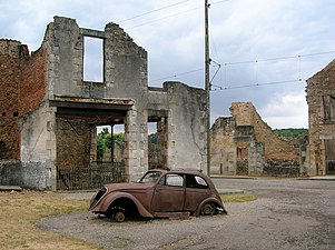 Ruined village
 -


See also edit
- Lidice, Czech village destroyed by Nazi forces in 1942
References edit
- ^ "Répertoire national des élus: les maires". data.gouv.fr, Plateforme ouverte des données publiques françaises (in French). 2 December 2020.
- ^ "Populations légales 2021". The National Institute of Statistics and Economic Studies. 28 December 2023.
- ^ Des villages de Cassini aux communes d'aujourd'hui: Commune data sheet Oradour-sur-Glane, EHESS (in French).
- ^ Population en historique depuis 1968, INSEE
Bibliography edit
- Farmer, Sarah. Martyred Village: Commemorating the 1944 Massacre at Oradour-sur-Glane. University of California Press, 2000.
- Fouché, Jean-Jacques. Massacre At Oradour: France, 1944; Coming To Grips With Terror, Northern Illinois University Press, 2004.
- Penaud, Guy. La "Das Reich" 2e SS Panzer Division (Parcours de la division en France, 560 pp), Éditions de La Lauze/Périgueux. ISBN 2-912032-76-8