


Summary
Orleans (/ɔːrˈliːnz/; French: [ɔʁleɑ̃]; officially and in French Orléans[1][note 1]) is a community in Ottawa, Ontario, Canada. It is located in the east end of the city along the Ottawa River, about 16 km (10 mi) from Downtown Ottawa. The Canada 2021 Census determined that Orléans' population was 125,937. Before being amalgamated into Ottawa in 2001, the community of Orléans was spread over two municipal jurisdictions, the eastern portion being in the pre-amalgamation City of Cumberland, the western portion in the City of Gloucester. According to the 2021 census, 75,453 people lived in the Cumberland portion of Orleans, while 50,484 lived in the Gloucester portion. Today, Orléans spans the municipal wards of Orléans East-Cumberland, Orléans West-Innes, and Orléans South-Navan. Orléans contains a significant francophone population.
Orleans | |
|---|---|
Community | |
| Orléans | |
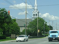 St-Joseph d'Orléans Parish, built in 1830 | |
 Orleans Location in Ottawa | |
| Coordinates: 45°28′N 75°31′W / 45.467°N 75.517°W | |
| Country | Canada |
| Province | Ontario |
| City | Ottawa |
| Parish of St-Joseph d'Orléans | 1830s |
| Police Village of St-Joseph d'Orléans | 1922 |
| Community of Orléans | 1974 |
| City of Ottawa | 2001 |
| Government | |
| • City councillors | Catherine Kitts, Laura Dudas, Matthew Luloff |
| • Member of Parliament | Marie-France Lalonde |
| • Member of Provincial Parliament | Stephen Blais |
| Population (2021) | |
| • Total | 125,937 |
| Time zone | UTC−5 (Eastern (EST)) |
| • Summer (DST) | UTC−4 (EDT) |
| Area code(s) | Area codes 613 and 343 |
History edit

It was in the 1830s that the earliest pioneers arrived in the Orléans area. The Dupuis, Besserer, Major, Duford, and Vézina families were among the first Francophones. A few English-speaking families also made Orléans their home from the very beginning, such as the Kennys and the McNeelys. In 1880, the parish consisted of 43 Anglophone families and 131 Francophone families.
In 1858, the first subdivision plans (Lots 1 and 2) were registered in the County of Carleton for Gloucester Township, creating the Village of Saint-Joseph d'Orléans. In 1859, François Dupuis also registered his plan (Lot 3), including St. John (St-Jean), Dupuis (Dessere), and Scott Streets (St-Charles).
Monsignor Ebrard named Orleans in the late 1850s after the city of the same name in France. According to the Canadian Permanent Committee on Geographical Names files, he applied for the establishment of a post office "plus tard en 1859." It was granted in 1860.[2]
In 1860, Father Alphonse-Marius Chaîne was appointed resident priest of the new Saint-Joseph d’Orléans parish, founded in October of the same year.
In 1885, the first church opened its doors. In 1922, a second church - the current one - replaced the first, which had been destroyed by fire. The parish priest was Mgr. Hilaire Chartrand.
In the same year (1922), Orléans became a semi-autonomous municipality, known as a police village, and more decisions were made locally. The police village was governed by a council of three volunteers elected to preserve peace, health, and public safety. At the time, the village was part of Gloucester Township, which in turn, was part of Carleton County. However, some parishioners lived in Cumberland Township, east of Champlain Street, the dividing line between the townships.
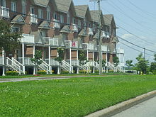
By the 1950s, St-Joseph Boulevard became a major artery, with storefronts multiplying everywhere and new restaurants opening up the length of the through fare. Social life took on a decidedly community flavour, with clubs and community associations being formed. Commercial life improved considerably in Orléans in 1955 with the establishment of the first Chamber of Commerce, which campaigned on behalf of various causes, such as pressing for a decent water and sewer system in the 1960s. The quiet, rural community that was once Orléans lived its last moments in 1958 when developers hit the town, and from then on, things would never be the same. Orléans has known dramatic residential growth since then, which has led to profound social and linguistic changes in the population's makeup.
The first significant real estate development was Queenswood Heights, with construction beginning in 1958. In 1970, the Grey Nuns of Charity Congregation sold 500 acres of land to the Costain and Minto real estate companies, which launched significant developments in the Convent Glen, Orléans Wood, Chatelaine Village areas, etc.
On 1 January 1974, the village of Saint-Joseph d’Orléans was incorporated into the Regional Municipality of Ottawa-Carleton. It was in the 1970s that the first high schools opened their doors, and after class hours, Orléans youth started setting up their clubs.
The housing and population boom years for Orléans came in the decade from 1981 to 1991. The population of Orléans tripled and grew from 24,000 to 70,000 people. Orléans recorded the second-highest population growth rate in the entire country in the late 1980s.
In 1989, Orléans became a municipality, Cumberland Township moved its city hall from Leonard, Ont. to Orléans. Orleans continued its residential developments through the 1990s. In addition to the residential developments, the 1990s in Orleans saw the final expansion of the Place d'Orléans shopping centre, a movie theatre, several new restaurants, new businesses, four new high schools, etc.
In 2001, Orléans was amalgamated into the City of Ottawa, becoming Urban sub-area No. 16 (now No. 15). The country-wide housing boom starting from 2000 has also seen a considerable amount of housing and residential areas being developed in the eastern Orléans area west of Trim Road and south of Innes Road, such as the new communities Avalon, Notting Gate (including Notting Hill). The population and business growth in the area prompted the re-development of Innes Road from a two-lane to a four-lane road in 2005. With the Innes Road expansion, newer business areas along Innes Road between Trim and Pagé Roads consist of many large retail outlets, restaurants, gyms, a movie theatre, etc.
Timeline edit
- 1833 – François Dupuis, founder of Orléans, is listed on the St. Joseph assessment rolls.
- 1834 – First Anglo settlers arrive in Blackburn Hamlet.
- 1836 – Cummings Bridge links Montreal Road to Bytown.
- 1846 – François Dupuis arrives with wife Mary Scott in what will be Orléans
- 1849 – First Catholic Chapel Saint-François-Xavier opens on land donated by François Dupuis.
- 1850 – Post Office opens in Notre-Dame-de-Lourdes.
- 1850 – Road opened between Cumberland and Gloucester and Bytown.
- 1850 – Toll gate opens at Green’s Creek.
- 1850 – Besserer family begins operating a summer resort at Besserer’s Grove with a quay at Besserer’s Landing – closed in 1885.
- 1855 – Father François-Joseph Michel opens a Catholic mission in Cumberland, previously known as Foubertville.
- 1856 – Luc Major arrives in Orléans and opens a tavern.
- 1858 – Luc Major draws up the first plan of Orléans
- 1860 – Postmaster Jean Théodore Besserer gives St-Joseph-d’Orléans its name after his place of birth.
- 1860 – A private French school opened in Orléans.
- 1868 – McArthur Road opens as a shortcut to Cyrville through McArthur Farm to avoid costly Montreal Road tolls.
- 1871 – Start construction on St-Joseph-d’ Orléans Church – completed in 1885.
- 1882 – Canada Atlantic Railway opens from Ottawa to Carlsbad Springs and Maritimes. Today, it is a Via Rail line
- 1885 – Grey Nuns buy 500 acres for giant Youville Farm in Orléans.
- 1890 – The first Catholic separate school opened in Orléans. Grey Nuns run it.
- 1891 – Construction of St. Joseph Church rectory.
- 1893 – Orléans opens cemetery behind St-Joseph Church
- 1895 – Irish Catholics opened the first English-language separate school in Orléans, which was demolished in 1956.
- 1900 – Antoine Leduc opens hotel in Orléans
- 1902 – CPR Short Line Railway opens from Ottawa to Blackburn Hamlet. Orléans also asks for a railway.
- 1909 – CN Railway opens line from Ottawa to Orléans and Hawkesbury. Land used for Queensway after the rail line closed in 1939.
- 1910 – (April 6) Hiawatha Park subdivision approved – not be developed until the 1950s.
- 1911 – Temperance sweeps Ontario. The sale of liquor is banned in every tavern, inn and place of entertainment in Orléans
- 1915 – First police constable appointed in Orléans
- 1917 – Oblate Fathers arrive and open Saint-Joseph Farm – closed in 1963 and became Ferme d’Orléans
- 1920 – Orléans gets its first bank, the Provincial Bank of Canada
- 1920 – Construction started on present-day St. Joseph Church – it only took two years to build.
- 1922 – St-Joseph-d’Orléans incorporated as a semi-autonomous “Police Village” with partial powers.
- 1925 – Dr. Émile Major is the first resident doctor in Orléans
- 1939 – Reeve Jack Innes dies in office. Saint-François Concession Road was renamed after him.
- 1940 – St. Joseph School replaces Académie St-Joseph.
- 1945 – Queensway being built on the old rail line in Ottawa
- 1952 – Highway 17 rebuilt through Orléans
- 1953 – St-Louis-de-Montfort Hospital opens.
- 1954 – Passenger service discontinued on the Ottawa and New York railway between Ottawa and Cornwall
- 1956 – (May 15) Fighter jet crashes into Grey Nuns Villa St-Louis Convent in Orléans – 15 killed.
- 1957 – The Ottawa and New York Railway (New York Central) was abandoned
- 1957 – Orléans gets first fire station. It will burn down two years later.
- 1958 – Orléans public library opens in the school basement – only public library in Gloucester until 1971.
- 1958 – NCC predecessor expropriates 22,500 acres of Gloucester farmland for the Greenbelt.
- 1958 – Orléans fails in bid for full municipal status.
- 1960 – Queensway opens from Hurdman’s to Green’s Creek.
- 1962 – The first library board was established in Orléans.
- 1962 – Green’s Creek Pollution Control Centre opens.
- 1962 – Motel Normandie opens.
- 1962 – Grandmaître family sells sand from Petrie Island
- 1967 – Water mains installed for the first time in Orléans.
- 1968 – Construction begins on Highway 417
- 1968 – Blair Road Queensway Interchange opens
- 1970 – Big housing boom starts in Orléans
- 1971 – Highway 417 reaches Gloucester.
- 1971 – Beacon Hill Bullet bus service starts to downtown
- 1971 – Gloucester Skating Club opens.
- 1972 – Garneau Secondary School opens, first in Orléans
- 1972 – Canadian Forces Station Gloucester closes down
- 1972 – OC Transpo extends city bus service to Beacon Hill, Blackburn Hamlet, and Orléans
- 1972 – Gloucester Coat of Arms put on police cars.
- 1973 – OC Transpo takes over Beacon Hill Bullet bus service
- 1973 – Blackburn Branch of Public Library opens.
- 1974 – Regional Municipality of Ottawa-Carleton absorbs Orléans.
- 1975 – Cairine Wilson Secondary School opens.
- 1976 – Blackburn Arena opens.
- 1977 – J.B. Potvin Arena opens.
- 1978 – (May) Gloucester Historical Society re-established.
- 1979 – MIFO was founded, which was a significant cultural boost.
- 1979 – First English-Catholic parish, Divine Infant
- 1979 – First Protestant Church, Orléans United Church
- 1980 – Orleans Recreation Complex opens.
- 1980 – Place d’Orléans Shopping Centre opens.
- 1981 – The Township of Gloucester was incorporated as a city.
- 1983 – The first newspaper in Orléans, the bilingual Express.
- 1986 – First English-language newspaper, Orleans Star
- 1989 – Third municipal office opened in Orléans
- 2001 – Orléans absorbed into the City of Ottawa
- 2003 – Petrie Island turned into a recreation area
- 2007 – Orléans Recreation Complex renamed Bob MacQuarrie Recreation Complex
- 2009 – Opening of Shenkman Arts Centre
- 2010 – Cité Collégiale opens a Trades school – Alphonse-Desjardins
Recreation and arts edit
Bob MacQuarrie Recreation Complex (formerly Orléans Recreation Complex) houses the Elizabeth Manley Figure Skating Arena, the Roger Sénécal Arena, squash and racquetball courts and a fitness centre. Various recreation programs include fitness classes, summer camps, indoor cycling, aqua fitness, swimming lessons and general interest programs. The Elizabeth Manley skating rink at the Bob MacQuarrie Recreation Complex is named for figure skater Elizabeth Manley who trained at the facility. Manley won a Silver Medal in Women's figure skating in the 1988 Calgary Winter Olympics. It is home to the Gloucester Skating Club and the Canadian Academy of Skating Arts. The skating club is well known for sending skaters to national and international competitions.
Ray Friel Recreation Complex is the largest and most comprehensive recreation complex in Orleans, featuring three National Hockey League (NHL) size arenas, including the Ron Racette Arena, with 12 full dressing rooms and separate referee and alternate dressing rooms. The complex also features a fitness centre with over 20,000 square feet of state-of-the-art training equipment, a wave pool, whirlpool, sauna, physiotherapy clinic, Douvris Martial Arts, pro shop, restaurant and a coffee shop. Various recreation programs include fitness classes, summer camps, indoor cycling, aqua fitness, swimming lessons and general interest programs.
Millennium Sports Park is a 34-hectare sports and recreational complex, consisting of 15 Soccer and Football fields located at 100 Millennium Blvd in Orleans. The closest major intersection to the Sports Park is Innes Road @ Trim Road. The site is currently home to several youth sporting clubs in the Eastern half of the Greater Ottawa Area. Currently, the largest tenants at the facility are the Ottawa TFC soccer club (formerly known as the Cumberland United Soccer Club) and the Cumberland Panthers football club.
Petrie Island is situated along the Ottawa River northeast of Orléans. The Petrie Islands were formed by sand deposited at the close of the last ice age, about 12,000 years ago. The 2 km by 500 m area, from the foot of Champlain St. to Trim Rd in Orleans, has a total shoreline length, including all channels and bays, of about 12 km. Much of the area has been publicly owned since 1983, purchased to preserve the natural habitat of the western portion of the islands. Sand dredging at the eastern end was phased out in 2003, and the ten-hectare sand fill and natural beach is now used for public recreation. Petrie Island is home to turtles in some of its sheltered lagoons and has a nature centre for learning more about the local environment. There is a marina with canoe and kayak rentals. Petrie Island hosts annual Canada Day celebrations for the Orléans community.
There are also several nature trails and paths throughout the area, including the Bilberry Creek Trail and the Princess Louise Trail (incl. a waterfall) through which Taylor Creek runs. In 1984, the Township formed a committee to develop a policy for the use of Conservation lands and approved the policy in March 1985. In 1988 a Township-wide Nature trails sub-committee was formed under the Cumberland Township Recreation committee. This Committee, composed of volunteer Township residents, advises and assists the Township in developing, maintaining and protecting the natural areas within Cumberland.
At present, there are:
- 2.7 km of trails in Chatelaine Village
- 5.5 km of trails in Queenswood/Fallingbrook Escarpment
- 9 km of trails in Ravine – Township Western boundary (Q.H.)
- 2 km of trails in Cumberland Village
In 2009, the Shenkman Arts Centre opened just east of Place d'Orléans. It is a multidisciplinary arts centre that houses two theatres, seven galleries and 17 studios. The Centre houses activities within specialized spaces for hands-on instruction, creation and presentation of the visual, performing, literary and media arts and unique spaces for receptions and special events. Operated by the City of Ottawa, this diversity of programs and activities is attributed to a unique collaboration with the Centre’s Resident Arts Partners: AOE Arts Council, Gloucester Pottery School, MIFO (Mouvement d’implication francophone d’Orléans), Ottawa School of Art–Orléans Campus, and OYP Theatre School. The Centre is also home to Resident Company Tara Luz Danse and ARTicipate, a one-of-a-kind endowment fund that supports innovative programming at the Centre.
A memorial diorama by Bruce Garner was erected August 13, 2000 in the Memorial Park near Royal Canadian Legion, Branch 632 to remember those who have served Canada in wars and as peace keepers.[3]
Neighbourhoods edit

- Avalon: Located south of Innes Road, west of Portobello Boulevard and east of Mer-Bleue Road.
- Bilberry Creek: Located east of Jeanne d'Arc Boulevard, north of Highway 174 and east towards the eastern end of the development.
- Cardinal Creek: Located north of Innes Road, west of Cardinal Creek and St-Joseph Blvd. Western boundary overlaps with Fallingbrook.[4]
- Chapel Hill North: Located north of Innes Road in the Orléans Boulevard area and south of St-Joseph Boulevard.
- Chapel Hill South: Located south of Innes Road and north of Navan Road.
- Chaperal: Located south of Innes Road and north of Brian Coburn Blvd, between Mer Bleue Road and Tenth Line Road.
- Chateauneuf: It is bounded by St-Joseph Boulevard on the north and Innes Road on the south. The eastern border includes Jeanne d'Arc-Sunview-Des Grives-Barsona-Place Belleterre-Duford Drive, and Orléans Boulevard borders the west.
- Chatelaine Village: Located north of Highway 174 toward the Ottawa River and East of Willow Ave.
- Convent Glen: Located north of Highway 174 toward the Ottawa River and west of Jeanne d'Arc Boulevard.
- Convent Glen South: Located south of Highway 174, north of St. Joseph Blvd and generally west of Orléans Blvd.
- Eastridge [1]: Future community situated near Trim Road and Blackburn By-Pass Road south of Notting Gate community.
- Fallingbrook: Located south of St-Joseph Boulevard, west of Trim Road, north of Innes Road and east of Tenth Line Road.[5]
- Hiawatha Park: An older neighbourhood on the Ottawa River, located north of Convent Glen.
- Notre-Dame-des-Champs: Located near Mer Bleue and Navan Road.
- Notting Gate: Located south of Innes Road, east of Portobello Boulevard, and west of Trim Road.
- Orleans Village: The oldest part of Orleans, located along St-Joseph Blvd between Orléans Blvd and Duford Dr.
- Orleans Wood: Located north of Highway 174 toward the Ottawa River, east of Jeanne d'Arc Boulevard and west of Champlain Street.
- Queenswood Heights: Located south of St-Joseph Boulevard, west of Tenth Line Road, east of Duford Road.[6]
- Queenswood Village: Older neighbourhood located between Champlain St and Willow Ave, north of Highway 174.
- River Walk: Located east of Tenth Line, north of Highway 174.
Population history edit
- 1971 – 6,000
- 1976 – 11,000
- 1981 – 24,000
- 1986 – 47,000
- 1991 – 70,000
- 1996 – 79,000
- 2001 – 84,695
- 2006 – 95,491
- 2011 – 107,823
- 2016 – 116,688
- 2021 - 125,937
Schools and education edit
English Catholic edit
- High school
- Elementary
- Blessed Kateri Tekakwitha Catholic School
- Chapel Hill Catholic School
- Convent Glen Catholic School
- Divine Infant Catholic School
- Our Lady of Wisdom Catholic School
- St. Clare Catholic School
- St Francis of Assisi Catholic
- St. Teresa Catholic School
- Good Shepherd Catholic School
- St. Dominic Catholic School
French Catholic edit
- High school
- École secondaire catholique Béatrice-Desloges
- École secondaire catholique Garneau
- Collège catholique Mer-Bleue
- Elementary
- École élémentaire catholique Arc-en-ciel
- École élémentaire catholique de la Découverte
- École élémentaire catholique Alain-Fortin
- École élémentaire catholique des Pionniers
- École élémentaire catholique des Voyageurs
- École élémentaire catholique L'Étoile-de-l'Est
- École élémentaire catholique Notre-Dame-des-Champs
- École élémentaire catholique Reine-des-Bois
- École élémentaire catholique Saint-Joseph d'Orléans
- École élémentaire catholique Sainte-Marie
- École élémentaire catholique d'enseignement personnalisé La Source
- École élémentaire catholique Des Villageois (Closed)
- École élémentaire publique Préseault (Closed)
French public edit
- High school
- École secondaire publique Gisèle-Lalonde
- Elementary
- École élémentaire Des Sentiers
- École élémentaire Jeanne-Sauvé
- École élémentaire L'Odyssée
- École élémentaire Le Prélude
English public edit
- High school
- Elementary
- Avalon Elementary School
- Convent Glen Elementary School
- Dunning-Foubert Elementary School
- Fallingbrook Community Elementary School
- Forest Valley Elementary School
- Henry Larsen Elementary School
- Maple Ridge Elementary School
- Orleans Wood Elementary School
- Summerside Elementary School
- Terry-Fox Public Elementary School
- Trillium Public Elementary School
Queenswood Public School closed in 2008(now Coccinelle (Garderie) École La Source)
Main roads and streets edit
- Orléans Blvd.
- Champlain St.
- Jeanne-d'Arc Blvd.
- Des Épinettes Ave.
- St-Joseph Blvd.
- Charlemagne Blvd.
- Innes Road
- Tenth Line Road
- Trim Road
- Portobello Blvd.
- Brian Coburn Blvd.
- Mer-Bleue Road.
The main highway linking Orléans to central Ottawa to the west is officially known as Ottawa Regional Road 174 and forms part of the Queensway.
- Place d'Orléans Dr.
Transportation edit
Public transportation in Orléans is provided by OC Transpo and is served by local bus routes 30,31,32,33,34,35 and 38, which provide service to/from Blair Station to each route's served neighbourhoods, while routes 131 and 138 run to/from Place d'Orléans Station. Route 39 is the only rapid or express route that serves Orléans, this route replaced the eastern part (after Blair) of the former route 95. While Connexion routes 221,222,224,225,228,231,232,233,234, 235,236, and 237 provides service to Blair on mornings, and back east to communities in the afternoon. The most frequent route is route 25, which travels via Innes, the most commercial and busy road of south Orléans, to/from La Cité or Millennium station (Ottawa).
All local, express, and most connexion routes that serve Orléans to/from Blair currently travel via the 174 with dedicated bus lanes. But this will be replaced by the LRT O-Train east extension once it opens in early 2025 with five under construction stations: Montréal station, Jeanne d'Arc Station, Convent Glen station, Place d'Orléans Station, and Trim Station, which will be the eastern terminus for both the Confederation line and line 3. All of these stations are being built in the median of the 174.
Notes edit
- ^ The suburb is called Orléans (with an accent) in French, but is commonly called Orleans (no accent) in English. The official name in English was changed from Orleans to Orléans by the Ontario Geographic Names Board in 1994. Still, the unaccented form remains common usage.
- History and Timeline information was collected from the information in the Orléans, Ontario PDF file uploaded to this page just below.
References edit
- ^ "Geographical Names Recommendations" (PDF). The Ontario Geographic Names Board. Retrieved 6 April 2016.
- ^ Hamilton, William (1978). The Macmillan Book of Canadian Place Names. Toronto: Macmillan. p. 163. ISBN 0-7715-9754-1.
- ^ "Memorial Park". National Inventory of Military Memorials. National Defence Canada. 2008-04-16.
- ^ "Map and Directions | Cardinal Creek Community Association".
- ^ "FCA Constitution". Archived from the original on 2008-02-29.
- ^ "Community Information – Queenswood Heights Community Association | l'Association communautaire de Queenswood Heights".