
KNOWPIA
WELCOME TO KNOWPIA

Ourville-en-Caux 
Summary
Ourville-en-Caux is a commune in the Seine-Maritime department in the Normandy region in northern France.
Ourville-en-Caux | |
|---|---|
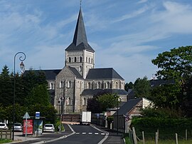 The church in Ourville-en-Caux | |
 Coat of arms | |
Location of Ourville-en-Caux .mw-parser-output .locmap .od{position:absolute}.mw-parser-output .locmap .id{position:absolute;line-height:0}.mw-parser-output .locmap .l0{font-size:0;position:absolute}.mw-parser-output .locmap .pv{line-height:110%;position:absolute;text-align:center}.mw-parser-output .locmap .pl{line-height:110%;position:absolute;top:-0.75em;text-align:right}.mw-parser-output .locmap .pr{line-height:110%;position:absolute;top:-0.75em;text-align:left}.mw-parser-output .locmap .pv>div{display:inline;padding:1px}.mw-parser-output .locmap .pl>div{display:inline;padding:1px;float:right}.mw-parser-output .locmap .pr>div{display:inline;padding:1px;float:left}html.skin-theme-clientpref-night .mw-parser-output .od,html.skin-theme-clientpref-night .mw-parser-output .od .pv>div,html.skin-theme-clientpref-night .mw-parser-output .od .pl>div,html.skin-theme-clientpref-night .mw-parser-output .od .pr>div{background:#000;color:#fff}html.skin-theme-clientpref-night .mw-parser-output .locmap{filter:grayscale(0.6)}@media(prefers-color-scheme:dark){html.skin-theme-clientpref-os .mw-parser-output .locmap{filter:grayscale(0.6)}html.skin-theme-clientpref-os .mw-parser-output .od,html.skin-theme-clientpref-os .mw-parser-output .od .pv>div,html.skin-theme-clientpref-os .mw-parser-output .od .pl>div,html.skin-theme-clientpref-os .mw-parser-output .od .pr>div{background:#000;color:#fff}}  Ourville-en-Caux  Ourville-en-Caux | |
| Coordinates: 49°43′47″N 0°36′23″E / 49.7297°N 0.6064°E | |
| Country | France |
| Region | Normandy |
| Department | Seine-Maritime |
| Arrondissement | Dieppe |
| Canton | Saint-Valery-en-Caux |
| Intercommunality | CC Côte d'Albâtre |
| Government | |
| • Mayor (2020–2026) | Jerôme Douillet[1] |
| Area 1 | 9.86 km2 (3.81 sq mi) |
| Population (2021)[2] | 1,105 |
| • Density | 110/km2 (290/sq mi) |
| Time zone | UTC+01:00 (CET) |
| • Summer (DST) | UTC+02:00 (CEST) |
| INSEE/Postal code | 76490 /76450 |
| Elevation | 55–135 m (180–443 ft) (avg. 110 m or 360 ft) |
| 1 French Land Register data, which excludes lakes, ponds, glaciers > 1 km2 (0.386 sq mi or 247 acres) and river estuaries. | |
Geography edit
A farming village with a little light industry, in the Pays de Caux, situated some 30 miles (48 km) northeast of Le Havre, at the junction of the D5, D50, D28 and D75.
Heraldry edit
 |
The arms of Ourville-en-Caux are blazoned : Quarterly: 1st, Vert a cow's head caboshed Argent; 2nd, Argent a dexter forearm in pale bearing a torch all Azure, 3rd, Argent a flax flower Azure; 4th Vert a sheep's head caboshed Argent.
|
Population edit
| Year | Pop. | ±% p.a. |
|---|---|---|
| 1968 | 693 | — |
| 1975 | 756 | +1.25% |
| 1982 | 896 | +2.46% |
| 1990 | 933 | +0.51% |
| 1999 | 1,041 | +1.22% |
| 2007 | 1,104 | +0.74% |
| 2012 | 1,084 | −0.36% |
| 2017 | 1,146 | +1.12% |
| Source: INSEE[3] | ||
Places of interest edit
- The church, dating from the nineteenth century.
See also edit
References edit
- ^ "Répertoire national des élus: les maires" (in French). data.gouv.fr, Plateforme ouverte des données publiques françaises. 13 September 2022.
- ^ "Populations légales 2021". The National Institute of Statistics and Economic Studies. 28 December 2023.
- ^ Population en historique depuis 1968, INSEE
Wikimedia Commons has media related to Ourville-en-Caux.