


Summary
The following outline is provided as an overview of and topical guide to Karnataka:
Karnataka is the 6th biggest, 8th most populous, 13th highest and 16th most literate state of the 28 states of the democratic Republic of India. Karnataka is ranked 3rd in the country in tax revenue and 7th in the country in GDP. Karnataka is at 8th position in life expectancy and 11th in female-to-male sex ratio among the states in India. Karnataka is at 7th most media exposed states in India.

General reference edit
Names edit
- Common name: Karnataka
- Previously known as :State of Mysore
- Pronunciation: /kərˈnɑːtəkə, kɑːr-/[1]
- Official name: Karnāṭaka
- Nicknames: Kannada nādu, Karunādu
- Adjectivals
- Demonyms
- Kannadigaru
- Kannadigas
- Canarese
- Abbreviations and name codes
Rankings (amongst India's states) edit
- by population: 8th
- by area: 6th
- by crime rate (2016): 12th
- by gross domestic product (GDP) (2019): 3rd
- by Human Development Index (HDI): 18th
- by life expectancy at birth: 10th
- by literacy rate: 23rd
Geography edit
- Karnataka is: an Indian state, a state of the Republic of India.
- Rainfall in Karnataka
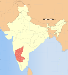
Location of Karnataka edit
- Karnataka is situated within the following regions:
- Time zone: Indian Standard Time (UTC+05:30)
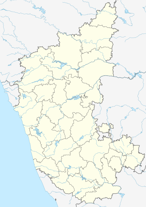
The state has three principal geographical zones:
East flowing rivers edit
26 east-flowing rivers.
- Amarja
- Arkavathy River
- Bhadra River
- Chakra River
- Dandavathi
- Ghataprabha River
- Hemavati River
- Honnuhole River
- Kabini River
- Kaveri River
- Kedaka River
- Krishna River
- Kubja River
- Lakshmana Tirtha River
- Malaprabha River
- Palar River
- Panchagangavalli River
- Penner River
- Ponnaiyar River
- Shimsha
- South Pennar River
- Tunga River
- Tungabhadra River
- Varada
- Vedavathi River
- Vrishabhavathi River
West flowing rivers edit

10 west-flowing rivers, providing 60% of state's inland water resources.
- Gangavalli River
- Aghanashini River
- Kali River
- Kumaradhara River
- Shambhavi River
- Varahi River
- Souparnika River
- Sharavathi River
- Kumadvathi River
- Netravati River
- Gurupura River
Reservoirs edit
- Alamatti
- Linganamakki
- Bhadra reservoir
- Tungabhadra dam, Hospete
- Krishna Raja Sagara
- Tippagondanahalli Reservoir
- Haringi dam
- Gorur dam.
- Kabini dam.
- Navilatirtha Dam, Saundatti taluka of Belgaum District
Lakes edit
- Lakes in Bangalore
- Mysore city lakes
- Unkal lake, Hubli
- Fort Lake Belgaum
- Heggeri Lake, Haveri
- Hagari Jalashaya, Malavi
Administrative divisions edit
Districts of Karnataka edit
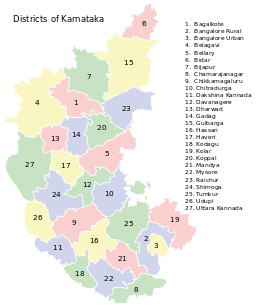
Districts of Karnataka There are 30 districts in Karnataka:
- Bagalkote
- Bengaluru Rural
- Bengaluru Urban
- Belagavi
- Bellary
- Bidar
- Vijayapura
- Chamarajanagar
- Chikkaballapur[11]
- Chikkamagaluru
- Chitradurga
- Dakshina Kannada
- Davanagere
- Dharwad
- Gadag
- Kalburgi
- Hassan
- Haveri
- Kodagu
- Kolar
- Koppal
- Mandya
- Mysuru
- Raichur
- Ramanagara[11]
- Shimoga
- Tumakuru
- Udupi
- Uttara Kannada
- Yadgir
Taluks of Karnataka edit
- Afzalpur
- Aland
- Alanvara
- Alur
- Anekal
- Ankola
- Annigeri
- Arkalgud
- Arsikere
- Athani
- Babaleshwar
- Badami
- Bagalkot
- Bagepalli
- Bailahongal
- Bangarapet
- Bantwal
- Basavakalyan
- Basavana Bagevadi
- Belgaum
- Bellary
- Beltangadi
- Belur
- Bengaluru East
- Bengaluru North
- Bengaluru South
- Bhadravati
- Bhalki
- Bhatkal
- Bidar
- Bidar
- Bijapur
- Bilagi
- Brahmavara
- Byadgi
- Baindur
- Chadchan
- Challakere
- Chamrajnagar
- Channagiri
- Channarayapattana
- Chik Ballapur
- Chikmagalur
- Chiknayakanhalli
- Chikodi
- Chincholi
- Chintamani
- Chitapur
- Chitgoppa
- Chitradurga
- Dandeli
- Davanagere
- Devadurga
- Devanhalli
- Devar Hipparagi
- Dharwad
- Doddaballapura
- Gadag-Betigeri
- Gangawati
- Ganjendragad
- Gauribidanur
- Gokak
- Gubbi
- Gudibanda
- Kalaburagi
- Guledgudda
- Gundlupet
- Gurmitkal
- Hagaribommanahalli
- Haliyal
- Hangal
- Hanur
- Harihar
- Harpanahalli
- Hassan
- Haveri
- Heggadadevanakote
- Hirekerur
- Hiriyur
- Holalkere
- Holenarsipur
- Homnabad
- Honavar
- Honnali
- Hoovina Hadagalli
- Hosanagara
- Hosdurga
- Hoskote
- Hospet
- Hubli city
- Hubli
- Hukkeri
- Hulsoor
- Hungund
- Hunsagi
- Hunsur
- Ilkal
- Indi
- Jagalur
- Jamkhandi
- Jevargi
- Joida
- Kadaba
- Kadur
- Kagawad
- Kalghatgi
- kanakapura
- Kamalapura
- Kamalnagar
- Kampli
- Kanakagiri
- Karatagi
- Karkal
- Karwar
- Khanapur
- Kittur
- Kolar
- Kolhar
- Kollegal
- Koppa
- Koppal
- Koratagere
- Kotturu
- Krishnarajanagar
- Krishnarajpet
- Kudligi
- Kukanur
- Kumta
- Kundapura
- Kundgol
- Kunigal
- Kurugodu
- Kushtagi
- Lakshmeshwara
- Lingsugur
- Maddur
- Madhugiri
- Madikeri
- Malavalli
- Malur
- Mandya
- Mangalore
- Manvi
- Maski
- Molakalmuru
- Moodbidri
- Mudalgi
- Muddebihal
- Mudhol
- Mudigere
- Mulbagal
- Mundargi
- Mundgod
- Mysore
- Nagamangala
- Nanjangud
- Narasimharajapura
- Nargund
- Navalgund
- Nelmangala
- Nidagundi
- Nipani
- Nyamati
- Pandavapura
- Pavagada
- Piriyapatna
- Puttur
- Rabkavi Banhatti
- Raichur
- Ramdurg
- Ranibennur
- Raybag
- Ron
- Sagar
- Sakleshpur
- Sanduru
- Saundatti
- Savanur
- Sedam
- Shahabad
- Shahpur
- Shiggaon
- Shikaripura
- Shimoga
- Shirahatti
- Shorapur
- Shrirangapattana
- Siddapur
- Sidlaghatta
- Sindagi
- Sindhnur
- Sira
- Sirsi
- Siruguppa
- Sirwar
- Somvarpet
- Sorab
- Sringeri
- Srinivaspur
- Sulya
- Talikota
- Tarikere
- Tikota
- Tiptur
- Tirthahalli
- Tirumakudalu Narasipura
- Tumkur
- Turuvekere
- Udupi
- Vadagera
- Virajpet
- Yadgir
- Yadrami
- Yelahanka
- Yelandur
- Yelbarga
- Yellapur
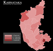
Demographics edit
Government and politics of Karnataka edit

- Form of government: Indian state government (parliamentary system of representative democracy)
- Capital of Karnataka: Bengaluru
- Elections in Karnataka
- (specific elections)
- Unification of Karnataka
Union government in Karnataka edit
- Rajya Sabha members from Karnataka
- Karnataka Pradesh Congress Committee
- Indian general election, 2009 (Karnataka)
- Indian general election, 2014 (Karnataka)
Branches of the government of Karnataka edit
Executive branch of the government of Karnataka edit
- Head of state: Governor of Karnataka
- Head of government: Chief Minister of Karnataka
- Council of Ministers of Karnataka
Legislative branch of the government of Karnataka edit
Karnataka Legislative Assembly
Judicial branch of the government of Karnataka edit
Law and order in Karnataka edit
Law of Karnataka
- Law enforcement in Karnataka
History edit

- Nanda Empire
- Mauryan empire of Emperor Ashoka
- Satavahana
- Kadambas
- Kadamba Dynasty founded by Mayurasharma
- Western Ganga Dynasty
- Badami Chalukyas
- Rashtrakuta Empire of Manyakheta
- Western Chalukya Empire
- Hoysalas
- Vijayanagara empire
- Nayakas of Chitradurga
- Madakari Nayaka
- Kempegowda
- Moghuls
- architecture
- literature
- Literature
- literary metres
- Vesara style of architecture
- Indo-Saracenic
- Battle of Talikota
- Nizam of Hyderabad
- Tippu Sultan
- Ekikarana Movement
Culture edit

- Carnatic music
- Architecture of Karnataka
- Cuisine of Karnataka
- Kannada people
- Tulu people
- Kodava people
- Beary people
- Konkani people
- Folk arts of Karnataka
- Cinema of Karnataka
- Languages
- Dances
Symbols of Karnataka edit
- State animal: Indian Elephant
- State bird: Indian roller[13]
- State flower: Lotus
- State seal: Seal of Karnataka
- State tree: Sandalwood
Tourism edit
North Karnataka edit
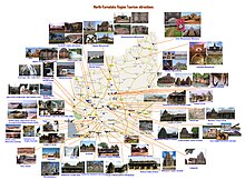
- World heritage centres


- Hampi[14]
- Group of 8th century CE monuments, Pattadakal:[15]
- Historical locations
- Western Chalukya
- Aihole:[16]
- Badami:[17]
- Basavana Bagewadi
- Basavakalyana,[18]
- Bidar District
- Annigeri
- Bankapura
- Dambal
- Haveri
- Gadag
- Lakkundi
- Someshwara temple complex Lakshmeshwar
- Galaganatha Galageshwara temple
- Chaudayyadanapura
- Mahadeva Temple (Itagi)
- Shambulinga Temple Kundgol
- Hooli Panchalingeshwara Temple
- Lakshmeshwar
- Kudalasangama
- Rashtrakuta dynasty
- Kadamba dynasty
- Deccan Sultanates
- Rattas
- Forts
- Basavakalyan Fort
- Bidar Fort
- Gulbarga Fort
- Savadatti Fort
- Bellary Fort
- Sandur Fort
- Gajendragad
- Nargund fort
- Other
- Western Chalukya
Coastal Karnataka edit
- Gokarna
- Mangalore
- Udupi
- Karkala
- Venur
- Malpe Beach
- Panambur Beach
- Kukke Subramanya
- Dharmastala
- Kollur
- Moodabidre
- Bhatkal
- Honnavar
- Ankola
- Murudeshwar
- Karwar
South Karnataka edit
See also edit
References edit
- ^ Jones, Daniel (2003) [1917], Peter Roach; James Hartmann; Jane Setter (eds.), English Pronouncing Dictionary, Cambridge: Cambridge University Press, ISBN 3-12-539683-2
- ^ "Location & Boundaries of Karnataka". Karnataka.com. 2007-07-14. Retrieved 2013-10-17.
- ^ "Location map of Karnataka, Where is Karnataka". Mapsofindia.com. 2012-09-26. Retrieved 2013-10-17.
- ^ a b "Karnataka River Map, Karnataka Rivers". Mapsofindia.com. Retrieved 2013-10-17.
- ^ a b "River Systems Of Karnataka". Waterresources.kar.nic.in. Retrieved 2013-10-17.
- ^ a b "List of Rivers in Karnataka". Worldlistmania.com. 2013-08-13. Retrieved 2013-10-17.
- ^ G. Sathyamoorthi (2012-10-05). "Water of west-flowing rivers of Karnataka remains unutilised". The Hindu. Retrieved 2013-10-17.
- ^ Bangalore, June 17, 2013, DHNS (2013-06-17). "Plentiful flow into Karnataka reservoirs". Deccanherald.com. Retrieved 2013-10-17.
{{cite web}}: CS1 maint: multiple names: authors list (link) CS1 maint: numeric names: authors list (link) - ^ "Lake Development Authority". Karnataka.gov.in. Retrieved 2013-10-17.
- ^ "Lake Development Authority". Karunadu.gov.in. Retrieved 2013-10-17.
- ^ a b "2 new districts notified in Bangalore". The Times of India. 6 August 2007. Archived from the original on 11 August 2011. Retrieved 2007-08-09.
- ^ A. R. Fatihi. "Urdu in Karnataka". Language in India, Volume 2: 2002-12-09. M. S. Thirumalai, Managing Editor, Language in India. Retrieved 2007-06-29.
- ^ Sankara Subramanian (2011-06-27). "Indian Roller–Karnataka's State Bird". Beontheroad.com. Retrieved 2013-10-17.
- ^ "hampi, UNESCO World Heritage Centre". Retrieved 2008-08-06.
- ^ "Pattadakal, UNESCO World Heritage Centre". Retrieved 2008-08-06.
- ^ "Aihole is located near Badami". 14 July 2007. Retrieved 2008-08-06.
- ^ "Badami Cave Temples, Karnataka". Retrieved 2008-08-06.
- ^ "New tourist spot to be developed". Retrieved 2008-08-08.
- ^ "Ancient and Medieval Historical Indian Architecture and Art - Bijapur". Kaladarshana. Archived from the original on 2013-10-10. Retrieved 2013-07-13.
- ^ "Bidar has 30 tombs of former kings". The Hindu. Chennai, India. 2008-08-06. Archived from the original on 2008-08-10. Retrieved 2008-08-08.
External links edit
 Definitions from Wiktionary
 Media from Commons
 News from Wikinews
 Quotations from Wikiquote
 Texts from Wikisource
 Textbooks from Wikibooks
 Resources from Wikiversity
 Travel information from Wikivoyage
![]() Wikimedia Atlas of Karnataka
Wikimedia Atlas of Karnataka
- Official website of the Government of Karnataka
- Karnataka at Curlie