
KNOWPIA
WELCOME TO KNOWPIA

Ouve-Wirquin 
Summary
Ouve-Wirquin (French pronunciation: [uv viʁkɛ̃]; Picard: Houffe-Wirquin; West Flemish: Ouve-Werchin) is a commune in the Pas-de-Calais department in the Hauts-de-France region of France.[3]
Ouve-Wirquin
Ouve-Werchin | |
|---|---|
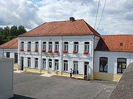 The town hall and school of Ouve-Wirquin | |
 Coat of arms | |
Location of Ouve-Wirquin .mw-parser-output .locmap .od{position:absolute}.mw-parser-output .locmap .id{position:absolute;line-height:0}.mw-parser-output .locmap .l0{font-size:0;position:absolute}.mw-parser-output .locmap .pv{line-height:110%;position:absolute;text-align:center}.mw-parser-output .locmap .pl{line-height:110%;position:absolute;top:-0.75em;text-align:right}.mw-parser-output .locmap .pr{line-height:110%;position:absolute;top:-0.75em;text-align:left}.mw-parser-output .locmap .pv>div{display:inline;padding:1px}.mw-parser-output .locmap .pl>div{display:inline;padding:1px;float:right}.mw-parser-output .locmap .pr>div{display:inline;padding:1px;float:left}html.skin-theme-clientpref-night .mw-parser-output .od,html.skin-theme-clientpref-night .mw-parser-output .od .pv>div,html.skin-theme-clientpref-night .mw-parser-output .od .pl>div,html.skin-theme-clientpref-night .mw-parser-output .od .pr>div{background:#fff;color:#000}html.skin-theme-clientpref-night .mw-parser-output .locmap{filter:grayscale(0.6)}@media(prefers-color-scheme:dark){html.skin-theme-clientpref-os .mw-parser-output .locmap{filter:grayscale(0.6)}html.skin-theme-clientpref-os .mw-parser-output .od,html.skin-theme-clientpref-os .mw-parser-output .od .pv>div,html.skin-theme-clientpref-os .mw-parser-output .od .pl>div,html.skin-theme-clientpref-os .mw-parser-output .od .pr>div{background:white;color:#000}}  Ouve-Wirquin  Ouve-Wirquin | |
| Coordinates: 50°39′05″N 2°08′44″E / 50.6514°N 2.1456°E | |
| Country | France |
| Region | Hauts-de-France |
| Department | Pas-de-Calais |
| Arrondissement | Saint-Omer |
| Canton | Lumbres |
| Intercommunality | Pays de Lumbres |
| Government | |
| • Mayor (2020–2026) | Ghislain Wilquin[1] |
| Area 1 | 5.25 km2 (2.03 sq mi) |
| Population (2021)[2] | 498 |
| • Density | 95/km2 (250/sq mi) |
| Time zone | UTC+01:00 (CET) |
| • Summer (DST) | UTC+02:00 (CEST) |
| INSEE/Postal code | 62644 /62380 |
| Elevation | 52–137 m (171–449 ft) (avg. 59 m or 194 ft) |
| 1 French Land Register data, which excludes lakes, ponds, glaciers > 1 km2 (0.386 sq mi or 247 acres) and river estuaries. | |
Geography edit
Ouve-Wirquin lies about 10 miles (16 km) southwest of Saint-Omer, on the junction of the D225 and the D341, the route of the Roman road the Chausée Brunehaut. The river Aa flows through the commune.
Population edit
| Year | Pop. | ±% p.a. |
|---|---|---|
| 1968 | 490 | — |
| 1975 | 478 | −0.35% |
| 1982 | 486 | +0.24% |
| 1990 | 486 | +0.00% |
| 1999 | 494 | +0.18% |
| 2007 | 536 | +1.03% |
| 2012 | 524 | −0.45% |
| 2017 | 506 | −0.70% |
| Source: INSEE[4] | ||
Places of interest edit
- The church of Notre-Dame, dating from the nineteenth century.
- An eighteenth-century watermill.
See also edit
References edit
- ^ "Répertoire national des élus: les maires" (in French). data.gouv.fr, Plateforme ouverte des données publiques françaises. 13 September 2022.
- ^ "Populations légales 2021". The National Institute of Statistics and Economic Studies. 28 December 2023.
- ^ INSEE commune file
- ^ Population en historique depuis 1968, INSEE
Wikimedia Commons has media related to Ouve-Wirquin.