


Summary
'olol'koy Beach Park is a public beach, playground, and picnic area operated by the city of Oxnard, California at the edge of the Oxnard Plain.[1]
| 'olol'koy Beach Park | |
|---|---|
| formerly Oxnard State Beach and Oxnard Beach Park | |
  | |
| Location | 1601 South Harbor Boulevard, Oxnard, California, U.S. |
| Coordinates | 34°10′57″N 119°14′13″W / 34.18250°N 119.23694°W |
| Area | 62 acres (25 ha)[1] |
| Created | 1989[1] |
| Operated by | City of Oxnard |
| GNIS feature ID | 1871139[2] |
Description edit
The park is located along the California Coastal Trail and the Pacific Coast Bicycle Route.[3] The park includes palm tree lined pathways and a bike/walking path connecting the communities of Oxnard Shores and Channel Islands Beach.[4] There is also an easy bike/walking connection to Channel Islands Harbor. 'olol'koy Beach Park includes two barbecue areas with a capacity of 200 occupants, each with a public sink, table, and a large grill. Activities include beachcombing, walking, and ocean swimming.[5] The park was designed to protect the sand dunes between the beach and grass picnic area.[6]
History edit
Jean Harris persuaded city of Oxnard leaders to adopt a grand vision in the creation of this park.[7] The State of California initially purchased a 26-acre (11 ha) site for the park in 1979.[6] The developer of an adjacent residential with a hotel site dedicated an additional 36 acres (15 ha), giving the park its present size of 62 acres (25 ha).[8] With the adoption of an operating agreement between City and State in December 1983, plans were developed for this park that was initially called Oxnard State Beach.[9] The park was transferred to City of Oxnard in 1998.[2][10] In 2023, the city council approved renaming the park 'olol'koy, the Chumash word for dolphin to honor the original inhabitants of the land.[11][12]
Gallery edit
-
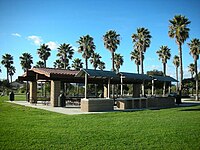 Barbecue area
 -
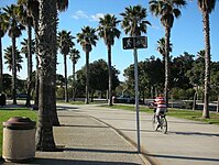 Walkway


See also edit
References edit
- ^ a b c "Parks Amenities Listing, Parks Information". City of Oxnard. Retrieved September 21, 2013.
- ^ a b U.S. Geological Survey Geographic Names Information System: Oxnard Beach Park
- ^ "Oxnard Beaches: A Visitors Guide". Visit Oxnard. June 15, 2017. Retrieved June 8, 2020.
- ^ Plascencia, Anthony (August 9, 2018). "Your guide to Ventura County beaches". Ventura County Star. Archived from the original on July 18, 2019. Retrieved August 21, 2018.
- ^ Cerball, Alejandra (January 19, 2021). "Oxnard's Best Local Parks: Where to Picnic". Visit Oxnard. Retrieved February 12, 2021.
- ^ a b Public Resources Code "Section 5003.14" State of California
- ^ Kelley, Daryl (April 29, 2001) "Illness Forces Environmental Crusader to Sidelines." Los Angeles Times
- ^ Myers, David W. (December 14, 1986) "Court to Decide State's Beach Access Issue" Los Angeles Times
- ^ Staff report (October 19, 1986) "Beachfront Site to Be Dedicated" Los Angeles Times
- ^ Warchol, Richard (July 12, 1997). "Swimmer Lost Off Oxnard Beach". Los Angeles Times. Retrieved June 7, 2020.
- ^ Varela, Brian J. (April 5, 2023). "Oxnard Beach Park to receive Chumash name". Ventura County Star. Retrieved April 6, 2023.
- ^ Lehr, Tracy (October 1, 2023). "Oxnard Beach Park gets renamed 'olołkoy Beach Park after the Chumash name for dolphin". News Channel 3-12. Retrieved February 17, 2024.
External links edit
- Oxnard Beach Park Visitor Information