


Summary
Palmer is a town just east of the Adelaide Hills region of South Australia along the Adelaide-Mannum Road, 70 kilometres east-north-east of the state capital, Adelaide and 15 km west-north-west of Mannum (34°51′S 139°9′E / 34.850°S 139.150°E). It is located in the Mid Murray Council local government area.
| Palmer South Australia | |||||||||||||||
|---|---|---|---|---|---|---|---|---|---|---|---|---|---|---|---|
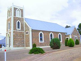 Palmer Lutheran Church | |||||||||||||||
 Palmer | |||||||||||||||
| Coordinates | 34°51′07″S 139°09′36″E / 34.852°S 139.160°E | ||||||||||||||
| Population | 215 (SAL 2021)[1] | ||||||||||||||
| Established | 1860s | ||||||||||||||
| Postcode(s) | 5237 | ||||||||||||||
| LGA(s) | Mid Murray Council | ||||||||||||||
| State electorate(s) | Schubert | ||||||||||||||
| Federal division(s) | Barker | ||||||||||||||
| |||||||||||||||
| Footnotes | [2] | ||||||||||||||
Palmer has a primary school (opened 1882),[3] a general store, hotel[4] and a Lutheran Church[5] of which Carl Heinrich Loessel was the first pastor, from 22 May 1869 before the church was built, succeeded by the long-serving Pastor Kuss.[6]
There are some rock formations at the Granite Boulders Area Geological Site.[7]
History edit
Palmer is sited on the western confines of the Indigenous Ngaralta people. The first European explorers through the Palmer district were Dr George Imlay and John Hill in January 1838.[8]
The Reedy Creek special survey was granted on 14 September 1846 to Enthoven, Capper and Masterman with Samuel Davenport as agent. The township of Palmer was laid out in August 1873 on section 960.[2] The town was named after Colonel George Palmer, a South Australian Colonisation Commissioner.[9] It was settled as a mining and agricultural settlement. The Kitticoola mine was discovered as a copper and gold deposit in 1845.[10] The remaining surface elements of the underground mine are heritage-listed.[11] Hillgrove Resources acquired rights for further mineral exploration in 2014.[12]
Heritage listings edit
Palmer has a number of heritage-listed sites, including:
References edit
- ^ Australian Bureau of Statistics (28 June 2022). "Palmer (SA) (suburb and locality)". Australian Census 2021 QuickStats. Retrieved 28 June 2022.
- ^ a b "Placename Details: Palmer (LOCB)". Property Location Browser Report. Government of South Australia. 26 March 2007. SA0053022. Archived from the original on 12 October 2016. Retrieved 17 March 2018.
- ^ Conlon, Keith; Halejko, Stan; Pancione, Sharyn; Palmer Primary School (S.A.); Palmer & Districts Association; Country Arts SA (2007), Palmer Primary School celebrates 125 years, 1882-2007, Palmer & Districts Association, retrieved 2 February 2019
- ^ White Pages Online. Retrieved 18 June 2006.
- ^ Lutheran Church of Australia. Retrieved 7 April 2007
- ^ "St. Paul's Lutheran Church, Palmer". The Mount Barker Courier and Onkaparinga and Gumeracha Advertiser. Vol. 48, no. 2548. South Australia. 27 September 1929. p. 5. Retrieved 5 April 2018 – via National Library of Australia.
- ^ a b "Granite Boulders Area Geological Site". South Australian Heritage Register. Department of Environment, Water and Natural Resources. Retrieved 28 May 2016.
- ^ "South Australia". The Australian. 27 March 1838. p. 3.
- ^ Place Names of South Australia, State Library of South Australia. Retrieved 9 July 2006.
- ^ "Kitticoola Mine (Great Wheal Orford; Plush and Omond; PM 53; Reedy Creek; Tungkillo), Palmer, South Mt Lofty Ranges (Adelaide Hills), Mt Lofty Ranges, South Australia, Australia". mindat.org. Hudson Institute of Mineralogy. Retrieved 2 February 2019.
- ^ a b "Kitticoola Mine". South Australian Heritage Register. Department of Environment, Water and Natural Resources. Retrieved 28 May 2016.
- ^ "Hillgrove Acquires Rights Over Kitticoola Cu/Au Prospect Near Kanmantoo, SA" (PDF). Hillgrove Resources. 3 June 2014. Retrieved 2 February 2019.
- ^ "Palmer Police Station & Cells". South Australian Heritage Register. Department of Environment, Water and Natural Resources. Retrieved 28 May 2016.
- ^ "Homestead Complex, including main house, two cottages, shearing shed, stable and piggery". South Australian Heritage Register. Department of Environment, Water and Natural Resources. Retrieved 28 May 2016.
- ^ "Reedy Creek Railway Bridge [Concrete Arch]". South Australian Heritage Register. Department of Environment, Water and Natural Resources. Retrieved 28 May 2016.
External links edit
- Map of Palmer (Mid Murray Council)