


Summary
Paloemeu or Palumeu is an Amerindian village in the interior of Suriname, situated at the site where the Paloemeu River joins the Tapanahoni River. Most inhabitants of the village are native Tiriyó Amerindians. The remainder belongs to the Wayana,[2] and Aparai tribes.[3] The Bosatlas in 1968 identified the village as Pepejoe which was incorrect according to the New West Indian Guide.[4]
Paloemeu
Palumeu | |
|---|---|
Village | |
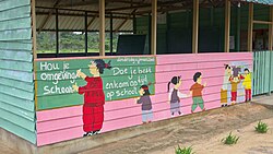 Primary school in Paloemeu | |
 Paloemeu Location in Suriname | |
| Coordinates: 3°20′43″N 55°26′35″W / 3.34528°N 55.44306°W | |
| Country | |
| District | Sipaliwini District |
| Resort (municipality) | Tapanahony |
| Government | |
| • Head captain | Essikeo Japawai[1] |
| Population (2020) | |
| • Total | 283[1] |
Overview edit
The village was visited three times by basiya Lodewijk Schmidt, a Saramaka Maroon from Gansee, who had been hired by the Surinamese government to contact and map the Amerindians living in the interior of Suriname.[5] On 18 January 1942, during his third expedition, Schmidt van Gansee installed Joeloe as the first Captain of the Tiriyó on Paloemeu River.[6] The village chief in 2022 was Essikeo Japawai.[1]
Paloemeu is home to a primary school,[7]: 171 and a Medische Zending healthcare centre.[8]
Paloemeu can be reached by the river or via the Vincent Fayks Airport. The 718 metre high Kasikasima mountain is located about 65 kilometres (40 mi) from the village. The journey will take 3 to 7 hours by boat.[9][10] There is a jungle ecotourism resort on the Tapanahony River for tourists.[7]: 192
Energy edit
Since the early 2000s there have been efforts to construct a micro hydroelectric power plant in the Panato creek to provide Paloemeu with electricity.[11] These efforts were initiated by the Dutch entrepreneur Arnout van de Werken. Several difficulties, including the flooding of the small reservoir in 2005, have hampered the project.[12] As of 2014, Palumeu still does not have full day electricity, and continues to rely on the few hours of diesel-generated electricity provided by the government.[13]
Notes edit
- ^ a b c "Dorpen en Dorpsbesturen". Vereniging van Inheemse Dorpshoofden in Suriname (in Dutch). Retrieved 22 June 2022.
- ^ Heemskerk et al. 2007, p. 39.
- ^ "Aparai". Socio Ambiental. Retrieved 1 April 2021.
- ^ Kruijer, G. J. (1968). "Reviewed work: Bos-Niermeyer Atlas der gehele Aarde, F. J. Ormeling". Nieuwe West-Indische Gids / New West Indian Guide (in Dutch). 46 (2): 188–193. JSTOR 41970171.
- ^ F.H.F. Oldenburger. "Baas Schmidt van Gansee" (PDF). Sipaliwini Savanna (in Dutch). pp. 1–2.
- ^ F. H. F. Oldenburger. "Verslag van de derde reis naar de Trio's in het gebied van de Sipaliwini en de Sitharé (11 december 1941-21 april 1942)" (PDF). Sipaliwini Savanna (in Dutch). p. 2.
- ^ a b "Planning Office Suriname - Districts" (PDF). Planning Office Suriname (in Dutch). Retrieved 13 January 2022.
- ^ "Zorggebied". Medische Zending.sr (in Dutch). Archived from the original on 30 September 2022. Retrieved 27 May 2020.
- ^ "Kasikasima Jungle Expeditie". Mets (in Dutch). Retrieved 29 May 2020.
- ^ "Kasikasima Tour". Sangfoo expeditions (in Dutch). Retrieved 15 January 2022.
- ^ The GEF Small Gifts Programme – Electrification of village Palumeu through application of micro hydropower works in the Panato creek
- ^ Tijseling, Alan (1 October 2007). "Palumeu, van de stroom en de dam die overstroomde". Parbode. Retrieved 25 April 2016.
- ^ "Inwoners Palumeu willen elektriciteit en drinkwater en voldoende leerkrachten". Obsession magazine. 25 April 2014. Retrieved 25 April 2016.
References edit
- Heemskerk, Marieke; Delvoye, Katia; Noordam, Dirk; Teunissen, Pieter (2007). Wayana Baseline Study: A sustainable livelihoods perspective on the Wayana Indigenous Peoples living in and around Puleowime (Apetina), Palumeu, and Kawemhakan (Anapaike) in Southeast Suriname (PDF). Paramaribo: Stichting Amazon Conservation Team-Suriname.