


Summary
Paratutae Island, also known as Paratūtai Island, is an island off New Zealand at the mouth of the Manukau Harbour, at Whatipu in the Waitākere Ranges area.
Native name: Motu Paratūtai | |
|---|---|
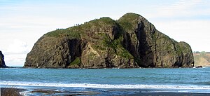 | |
| GeographyLocationAucklandCoordinates.mw-parser-output .geo-default,.mw-parser-output .geo-dms,.mw-parser-output .geo-dec{display:inline}.mw-parser-output .geo-nondefault,.mw-parser-output .geo-multi-punct,.mw-parser-output .geo-inline-hidden{display:none}.mw-parser-output .longitude,.mw-parser-output .latitude{white-space:nowrap}37°02′46″S 174°30′29″E / 37.046°S 174.508°E | |
| Adjacent to | Manukau Harbour, Tasman Sea |
| Highest elevation | 13 m (43 ft) |
| Administration | |
New Zealand | |

Geology edit
The island is a portion of a Miocene era volcanic dyke swarm.[1]
History edit
In Te Kawerau ā Maki oral histories, the island was visited by the Polynesian navigator Kupe. A section of the island is known by the name Te Hoe-a-Kupe ("The Paddle of Kupe"), referring to the location where Kupe struck his paddle against the island, to commemorate his visit.[2][3] The island was the location of a Te Kawerau ā Maki defensive pā, guarding the entrance to the Manukau Harbour.[4] Around the year 1700, the pā was captured by Kawharu, the famed Tainui warrior who led Ngāti Whātua warriors to take the Waitākere Ranges area.[4] The island is one of the few locations where pre-European Māori textiles have been found, during an archaeological survey in the early 1900s.[5]
The etymology of the island's name is contested. Many attest that the word is a corruption of Paratūtai, referring to the rise and fall of the tides at the Manukau Bar,[2][3] while a separate traditional story involves a chief visiting the island and developing diarrhea after eating too much para fern root (Ptisana salicina),[6][2] The rocky sections of Whatipu, Motu Paratūtai, Te Toka Tapu ā Kupe / Ninepin Rock and Te Marotiri ō Takamiro (Cutter Rock) were collectively known as Te Kupenga ā Taramainuku, or "The Fishing Net of Taramainuku".[3]
A signal mast was installed on the island in the 1850s, in order to improve safety for ships entering the Manukau Harbour.[7] In November 1863 during the Invasion of the Waikato, a Waikato raiding party climbed the island and cut down the signal mast.[7] In the latter 19th century, a wharf was constructed on the north-east side of the island.[7] Waitākere Ranges kauri timber would transported to the Whatipu sawmill and the wharf by tramway.[7] The wharf was used until 1921, and was demolished in 1950.[7]
While originally an island separated from the mainland, the sandbank at Whatipu gradually accumulated during the late 20th century to form a tombolo, so that by 1989 Paratutae had become a tied island.[7]
References edit
- ^ Hayward, B. W. (1977). "Miocene volcanic centres of the Waitakere Ranges, North Auckland, New Zealand". Journal of the Royal Society of New Zealand. 7 (2): 123–141. doi:10.1080/03036758.1977.10427155.
- ^ a b c "Paratutae Island". New Zealand Gazetteer. Land Information New Zealand. Retrieved 1 June 2022.
- ^ a b c Te Kawerau ā Maki; The Trustees of Te Kawerau Iwi Settlement Trust; The Crown (12 December 2013). "Deed of Settlement Schedule: Documents" (PDF). Retrieved 26 April 2022.
- ^ a b Diamond & Hayward 1979, pp. 5.
- ^ McKendry, Lisa (2017). "Māori Kākahu (Cloak) Fragments from Piha: Whakaari Pā". Records of the Auckland Museum. 52: 59–70. doi:10.32912/RAM.2018.52.4. ISSN 1174-9202. JSTOR 90016662. Wikidata Q104815051.
- ^ Diamond & Hayward 1979, pp. 44.
- ^ a b c d e f Murdoch, Graeme (2006). "Whatipu: Our History" (PDF). Auckland Council. Retrieved 6 July 2021.
Print references edit
- Diamond, John T.; Hayward, Bruce W. (1979). The Māori history and legends of the Waitākere Ranges. The Lodestar Press. ISBN 9781877431210.