
KNOWPIA
WELCOME TO KNOWPIA

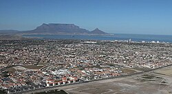
Parklands, Western Cape 
Summary
Parklands is a suburb of Cape Town, South Africa. It is near Blouberg, bordered by Tableview, Cape Town and is part of the Western Seaboard residential district.
Parklands | |
|---|---|
 | |
 Parklands  Parklands | |
| Coordinates: 33°48′52″S 18°30′09″E / 33.81444°S 18.50250°E | |
| Country | South Africa |
| Province | Western Cape |
| Municipality | City of Cape Town |
| Main Place | Bloubergstrand |
| Government | |
| • Councillor | Meisie Sarah Makuwa (Ward 104) (ANC) Jonathan Mills (DA) (Ward 107) |
| Area | |
| • Total | 2.47 km2 (0.95 sq mi) |
| Population (2011)[1] | |
| • Total | 14,476 |
| • Density | 5,900/km2 (15,000/sq mi) |
| Racial makeup (2011) | |
| • Black African | 30.7% |
| • Coloured | 10.4% |
| • Indian/Asian | 3.1% |
| • White | 54.2% |
| • Other | 1.6% |
| First languages (2011) | |
| • English | 56.7% |
| • Afrikaans | 16.3% |
| • Xhosa | 9.8% |
| • Zulu | 1.8% |
| • Other | 15.3% |
| Time zone | UTC+2 (SAST) |
| Postal code (street) | 7441 |
| PO box | 2121 |
Parklands is one of the fastest-growing residential developments in the Western Cape. It is characterised by lower-density suburban areas and higher-density apartment block areas; the latter are largely inhabited by African diaspora residents.[2][3]