


Summary
Parkside is an area and electoral ward of Barrow-in-Furness, Cumbria, England. It is bordered by Hindpool, Ormsgill, Hawcoat, Newbarns and Risedale and had a population of 5,742 in 2001,[1] reducing to 5,584 at the 2011 Census.[2] It is one of the town's most centralised wards and contains Barrow's main park (hence the ward's name), as well as the newly established Furness Academy.
| Parkside | |
|---|---|
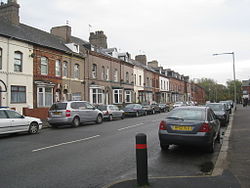 Ainslie Street east looking towards Barrow Park  Parkside shown within Barrow-in-Furness Parkside shown within Barrow-in-Furness | |
| Population | 5,584 (2011.Ward) |
| District | |
| Shire county | |
| Region | |
| Country | England |
| Sovereign state | United Kingdom |
| Post town | BARROW-IN-FURNESS |
| Postcode district | LA |
| Dialling code | 01229 |
| Police | Cumbria |
| Fire | Cumbria |
| Ambulance | North West |
| UK Parliament | |
Abbey Road - Barrow's principal road runs down the entire western side of Parkside. The majority of housing to the west of Abbey Road is terraced and semi-detached, whilst the eastern side of Parkside is predominantly parkland and fields with the exception of some semi and detached housing.
The ward itself will be combined with Ormsgill ward in April 2023 following formation of the new Westmorland and Furness Local Authority.
There are a number of place of worship in Parkside including Abbey Road Baptist Church, Spring Mount Christian Fellowship and Trinity Church Centre.[3]
Barrow's first synagogue was founded in 1902 on Abbey Road although it closed less than twenty years later.[4]
Parkside's ward is of the first to have a Communist Party of Britain council member.[5]
Barrow Park edit
Demographics edit
| Vital statistics[1] | Parkside | Barrow-in-Furness | England |
|---|---|---|---|
| Religious individuals | 81.93% | 81.61% | 77.71% |
| Non-religious individuals | 11.11% | 10.79% | 14.59% |
| Religion withheld | 6.95% | 7.59% | 7.69% |
| Individuals in fairly good to good health |
89.99% | 86.75% | 90.97% |
| Individuals in bad health | 10.01% | 13.25% | 9.03% |
| People aged 16–74 who are economically active |
67.73% | 60.84% | 66.87% |
| People aged 16–74 who aren't economically active |
32.27% | 39.16% | 33.13% |
| People aged 16–74 with no qualifications |
24.52% | 32.82% | 28.85% |
References edit
- ^ a b "Parkside: Key Figures for 2001 Census". Office for National Statistics. Retrieved 19 January 2011.
- ^ "Ward population 2011". Retrieved 13 June 2015.
- ^ "Places of Worship in Barrow-in-Furness". GENUKI. Retrieved 19 January 2011.
- ^ "Abbey Road/ Ainslie Street Synagogue". GENUKI. Retrieved 19 January 2011.
- ^ Barrow Borough Council, customerservices@barrowbc gov uk (30 March 2023). "Councillor details - Cllr Iain Mooney". democracy.barrowbc.gov.uk. Retrieved 30 March 2023.
External links edit
- ONS: Parkside Ward All Statistics
- Cumbria Constabulary: Parkside Ward Profile
54°07′12″N 3°12′58″W / 54.120°N 3.216°W