


Summary
Parnamirim is a city in the state of Rio Grande do Norte, Brazil, next to the state capital city of Natal and part of its metropolitan area.
Parnamirim | |
|---|---|
Municipality | |
| The Municipality of Trampolim da Vitória de Parnamirim | |
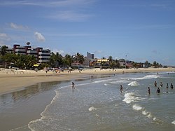 Pirangi do Norte Beach | |
 Flag  Seal | |
| Nickname: "Trampolim da Vitória" ("Trampoline of Victory") | |
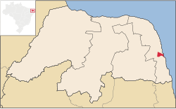 Location of Parnamirim in the State of Rio Grande do Norte | |
 Location of Rio Grande do Norte in Brazil | |
| Coordinates: 5°55′S 35°15′W / 5.917°S 35.250°W | |
| Country | |
| Region | Northeast |
| State | |
| Founded | 1958 |
| Government | |
| • Mayor | Rosano Taveira (PRB) |
| Area | |
| • Total | 123.471 km2 (47.672 sq mi) |
| Elevation | 48 m (157 ft) |
| Population (2020 [1]) | |
| • Total | 267,036 |
| • Density | 2,200/km2 (5,600/sq mi) |
| Time zone | UTC−3 (BRT) |
| HDI (2010) | 0.766 [2] – high |
| Website | parnamirim |
Natal Air Force Base - ALA10, one of the most important bases of the Brazilian Air Force, is located in Parnamirim at the former Augusto Severo International Airport. The site is also home to Barreira do Inferno rocket launch base.
Geography edit
Parnamirim belongs to the Intermediate Geographic Region of Natal and the Metropolitan Region of Natal. It is located on the coast with Atlantic Ocean, about 13 kilometers south of the urban center of Natal. Its average elevation is 48 meters above the sea level.[3]
Climate edit
Parnamirim has a Tropical Savanna Climate (As). It receives the most amount of rainfall in April, with 138 mm of average precipitation; and the least amount of rainfall in October, with 4 mm of average precipitation.
| Climate data for Parnamirim | |||||||||||||
|---|---|---|---|---|---|---|---|---|---|---|---|---|---|
| Month | Jan | Feb | Mar | Apr | May | Jun | Jul | Aug | Sep | Oct | Nov | Dec | Year |
| Mean daily maximum °C (°F) | 31 (88) |
31 (88) |
31 (88) |
31 (88) |
30 (86) |
29 (84) |
29 (84) |
29 (84) |
30 (86) |
30 (86) |
31 (88) |
31 (88) |
30 (87) |
| Daily mean °C (°F) | 27 (81) |
28 (82) |
28 (82) |
27 (81) |
26 (79) |
25 (77) |
25 (77) |
25 (77) |
26 (79) |
27 (81) |
27 (81) |
27 (81) |
27 (80) |
| Mean daily minimum °C (°F) | 24 (75) |
24 (75) |
24 (75) |
24 (75) |
23 (73) |
23 (73) |
22 (72) |
22 (72) |
22 (72) |
23 (73) |
24 (75) |
25 (77) |
23 (74) |
| Average rainfall mm (inches) | 40.5 (1.59) |
65.9 (2.59) |
107.2 (4.22) |
138.0 (5.43) |
118.6 (4.67) |
130.2 (5.13) |
88.8 (3.50) |
36.3 (1.43) |
15.4 (0.61) |
4.0 (0.16) |
6.0 (0.24) |
11.7 (0.46) |
762.6 (30.03) |
| Average rainy days (≥ 1 mm) | 6.0 | 8.2 | 13.0 | 15.0 | 13.8 | 13.8 | 10.8 | 5.8 | 2.4 | 0.9 | 1.3 | 2.3 | 93.3 |
| Mean daily daylight hours | 12.4 | 12.3 | 12.1 | 12.0 | 11.8 | 11.8 | 11.8 | 11.9 | 12.1 | 12.2 | 12.4 | 12.5 | 12.1 |
| Source: Weatherspark.com[4] | |||||||||||||
Galleries edit
-
 Cotovelo Beach in Parnamirim
 -
 Street view of Parnamirim


References edit
- ^ IBGE 2020
- ^ "Profile - Parnamirim, RN | Atlas of Human Development in Brazil". Archived from the original on 2020-07-12. Retrieved 2020-07-10.
- ^ "Parnamirim topographic map, elevation, terrain". Topographic maps. Retrieved 2023-04-27.
- ^ "Climate and Average Weather Year Round in Parnamirim, Brazil". weatherspark.com. Retrieved 2023-04-27.
External links edit
 Media related to Parnamirim at Wikimedia Commons
 Parnamirim travel guide from Wikivoyage