


Summary
Pattison is a city in Waller County, Texas, United States. As of the 2010 census, the population was 472.[5]
Pattison, Texas | |
|---|---|
 Location of Pattison, Texas | |
| Coordinates: 29°49′10″N 95°59′0″W / 29.81944°N 95.98333°W | |
| Country | United States |
| State | Texas |
| County | Waller |
| Government | |
| • Mayor | Joe Garcia |
| Area | |
| • Total | 3.53 sq mi (9.14 km2) |
| • Land | 3.53 sq mi (9.14 km2) |
| • Water | 0.00 sq mi (0.00 km2) |
| Elevation | 171 ft (52 m) |
| Population (2010) | |
| • Total | 472 |
| • Estimate (2019)[2] | 620 |
| • Density | 175.69/sq mi (67.83/km2) |
| Time zone | UTC-6 (Central (CST)) |
| • Summer (DST) | UTC-5 (CDT) |
| ZIP codes | 77423, 77466 |
| Area code | 281 |
| FIPS code | 48-56108[3] |
| GNIS feature ID | 1343685[4] |
| Website | pattisontexas |
Geography edit
Pattison is located at 29°49′10″N 95°59′0″W / 29.81944°N 95.98333°W (29.819385, –95.983413).[6]
According to the United States Census Bureau, the city has a total area of 3.2 square miles (8.4 km2), all land.
Climate edit
The climate in this area is characterized by hot, humid summers and generally mild to cool winters. According to the Köppen Climate Classification system, Pattison has a humid subtropical climate, abbreviated "Cfa" on climate maps.[7]
-
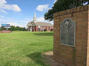 Texas historical marker at Pattison United Methodist Church marks the site of the old railroad depot.
 -
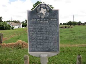 Texas historical marker is located on FM 359 at the James Tarrant Pattison home site.
 -
 Judge Edwin Waller historical marker is west of Pattison along FM 1458 near Buller Road.


Demographics edit
| Census | Pop. | Note | %± |
|---|---|---|---|
| 1980 | 318 | — | |
| 1990 | 327 | 2.8% | |
| 2000 | 447 | 36.7% | |
| 2010 | 472 | 5.6% | |
| 2019 (est.) | 620 | [2] | 31.4% |
| U.S. Decennial Census[8] | |||
As of the census[3] of 2000, there were 447 people, 166 households, and 126 families residing in the city. The population density was 137.8 inhabitants per square mile (53.2/km2). There were 186 housing units at an average density of 57.3 per square mile (22.1/km2). The racial makeup of the city was 81.43% White, 9.40% African American, 0.45% Native American, 0.89% Asian, 5.82% from other races, and 2.01% from two or more races. Hispanic or Latino of any race were 19.24% of the population.
There were 166 households, out of which 36.1% had children under the age of 18 living with them, 62.7% were married couples living together, 12.0% had a female householder with no husband present, and 23.5% were non-families. 21.7% of all households were made up of individuals, and 9.6% had someone living alone who was 65 years of age or older. The average household size was 2.69 and the average family size was 3.14.
In the city, the population was spread out, with 26.4% under the age of 18, 7.4% from 18 to 24, 25.3% from 25 to 44, 26.0% from 45 to 64, and 15.0% who were 65 years of age or older. The median age was 40 years. For every 100 females, there were 87.8 males. For every 100 females age 18 and over, there were 80.8 males.
The median income for a household in the city was $43,250, and the median income for a family was $55,938. Males had a median income of $35,833 versus $38,375 for females. The per capita income for the city was $17,982. About 5.7% of families and 6.6% of the population were below the poverty line, including 3.8% of those under age 18 and 7.0% of those age 65 or over.
Government and infrastructure edit
(Current as of 3/25/22)
Mayor - Joe Garcia
Council Member #1 – Wayne Kircher
Council Member #2 – Frank Cobio, Jr.
Council Member #3 – Robert MacCallum
Council Member #4 / Mayor Pro Tem – Seth Stokes
Council Member #5 – Randall Flowers
The United States Postal Service operates the Pattison Post Office at 3637 2nd Street.[9]
Education edit

The City of Pattison is served by the Royal Independent School District.
References edit
- ^ "2019 U.S. Gazetteer Files". United States Census Bureau. Retrieved August 7, 2020.
- ^ a b "Population and Housing Unit Estimates". United States Census Bureau. May 24, 2020. Retrieved May 27, 2020.
- ^ a b "U.S. Census website". United States Census Bureau. Retrieved January 31, 2008.
- ^ "US Board on Geographic Names". United States Geological Survey. October 25, 2007. Retrieved January 31, 2008.
- ^ "Population and Housing Unit Counts, 2010 Census of Population and Housing" (PDF). Texas: 2010. Retrieved January 2, 2017.
- ^ "US Gazetteer files: 2010, 2000, and 1990". United States Census Bureau. February 12, 2011. Retrieved April 23, 2011.
- ^ Climate Summary for Pattison, Texas
- ^ "Census of Population and Housing". Census.gov. Retrieved June 4, 2015.
- ^ "Post Office Location - PATTISON." United States Postal Service. Retrieved on December 4, 2008.
External links edit
- Pattison, Texas website
- Pattison, Texas from the Handbook of Texas Online