


Summary
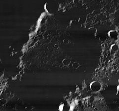
Peary is the closest large lunar impact crater to the lunar north pole. At this latitude the crater interior receives little sunlight, and portions of the southernmost region of the crater floor remain permanently cloaked in shadow. From the Earth the crater appears on the northern lunar limb, and is seen from the side.
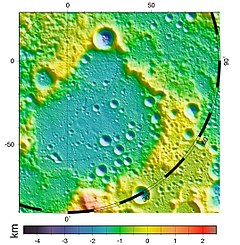
 Shaded relief map, based on the LRO laser altimetry data. Peary is the large crater at center; north pole is situated on its northern (upper) rim | |
| Coordinates | 88°38′N 24°24′E / 88.63°N 24.4°E |
|---|---|
| Diameter | 79 km |
| Depth | 1.5 km |
| Colongitude | 25° at sunrise |
| Eponym | Robert Peary |
Observation and Etymology edit
Since Peary is located nearly on the limb of the Moon as viewed from Earth, high-quality images of the crater were not available until space probes started photographing the Moon; the first high-quality images came from the US Lunar Orbiter 4 spacecraft.[1] Since it is located nearly at the lunar north pole, it was named after the polar explorer Robert Peary.[2]
Physical features edit
Peary is nearly circular, with an outward bulge along the northeast rim. There is a gap in the southwestern rim, where it joins the slightly smaller crater Florey. The outer rim of Peary is worn and eroded, creating a rugged mountainous ring that produces long shadows across the crater floor. The crater floor itself is relatively flat, but is marked by several small craterlets, particularly in the southeastern half. The southern third of the interior remains cloaked in shadows, and so its features can be readily discerned only by means of ranging methods (for example, laser altimetry).
Because of the low sun angle, the average temperature on the crater floor or Peary is between 30 and 40 K, one of the coldest locations in the Solar System.[3]
Illumination edit
In 2004, a team led by Dr Ben Bussey of Johns Hopkins University, using images taken by the Clementine mission, determined that four mountainous regions on the rim of Peary appeared to remain illuminated for the entire lunar day.[4] These unnamed "peaks of eternal light" are due to the Moon's extremely small axial tilt, which also gives rise to permanent shadow at the bottoms of many polar craters. Clementine's images were taken during the northern lunar hemisphere's summer season, and more detailed lunar topography collected by the Lunar Reconnaissance Orbiter (LRO) showed that no points on the Moon receive perpetual light during both winter and summer.[5]
The northern rim of Peary is considered a likely site for a future Moon base,[6] due to this near-constant illumination, which would provide both a relatively stable temperature and a nearly uninterrupted solar power supply. It is also near permanently shadowed areas that may contain some quantity of frozen water.[7]
References edit
- ^ Lunar Orbiter 4, NSSDCA/COSPAR ID: 1967-041A, NSSDC archive, NASA.
- ^ Blue, Jennifer (July 25, 2007). "Peary". Gazetteer of Planetary Nomenclature, USGS. Retrieved 2014-12-08.
- ^ "Ten Cool Things Seen in the First Year of LRO", NASA Goddard Space Center, June 23, 2010. Retrieved 22 May 2018.
- ^ McKee, Maggie (April 13, 2005). "Sunny spot picked out for future lunar base". New Scientist. Retrieved 2007-09-11.
- ^ Emerson J. Speyerer and Mark S. Robinson, "Persistently illuminated regions at the lunar poles: Ideal sites for future exploration", Icarus Vol. 222, No. 1, January 2013, pp. 122-136 https://doi.org/10.1016/j.icarus.2012.10.010 . Retrieved 21 May 2018.
- ^ Researchers find ideal spot for moon base, CNN, April 18, 2005 (accessed 2010 August 22)
- ^ P. Gläser, J. Oberst, G.A. Neumann, E. Mazarico, E.J. Speyerer, and M.S. Robinson, "Illumination conditions at the lunar poles: Implications for future exploration", Planetary and Space Science, 2017. https://doi.org/10.1016/j.pss.2017.07.006
- Andersson, L. E.; Whitaker, E. A. (1982). NASA Catalogue of Lunar Nomenclature. NASA RP-1097.
- Bussey, B.; Spudis, P. (2004). The Clementine Atlas of the Moon. New York: Cambridge University Press. ISBN 978-0-521-81528-4.
- Cocks, Elijah E.; Cocks, Josiah C. (1995). Who's Who on the Moon: A Biographical Dictionary of Lunar Nomenclature. Tudor Publishers. ISBN 978-0-936389-27-1.
- McDowell, Jonathan (July 15, 2007). "Lunar Nomenclature". Jonathan's Space Report. Retrieved 2007-10-24.
- Menzel, D. H.; Minnaert, M.; Levin, B.; Dollfus, A.; Bell, B. (1971). "Report on Lunar Nomenclature by the Working Group of Commission 17 of the IAU". Space Science Reviews. 12 (2): 136–186. Bibcode:1971SSRv...12..136M. doi:10.1007/BF00171763. S2CID 122125855.
- Moore, Patrick (2001). On the Moon. Sterling Publishing Co. ISBN 978-0-304-35469-6.
- Price, Fred W. (1988). The Moon Observer's Handbook. Cambridge University Press. ISBN 978-0-521-33500-3.
- Rükl, Antonín (1990). Atlas of the Moon. Kalmbach Books. ISBN 978-0-913135-17-4.
- Webb, Rev. T. W. (1962). Celestial Objects for Common Telescopes (6th revised ed.). Dover. ISBN 978-0-486-20917-3.
- Whitaker, Ewen A. (2003). Mapping and Naming the Moon. Cambridge University Press. ISBN 978-0-521-54414-6.
- Wlasuk, Peter T. (2000). Observing the Moon. Springer. ISBN 978-1-85233-193-1.
External links edit
- LAC-1 area - Map of northern lunar pole