
KNOWPIA
WELCOME TO KNOWPIA

Peillac 
Summary
Peillac (French pronunciation: [pɛjak] ⓘ; Breton: Paolieg; Gallo: Peilla) is a commune in the east of Morbihan department of Brittany in north-western France.[3]
Peillac
Paolieg | |
|---|---|
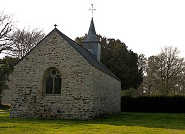 The chapel of Saint-Julien | |
 Coat of arms | |
Location of Peillac .mw-parser-output .locmap .od{position:absolute}.mw-parser-output .locmap .id{position:absolute;line-height:0}.mw-parser-output .locmap .l0{font-size:0;position:absolute}.mw-parser-output .locmap .pv{line-height:110%;position:absolute;text-align:center}.mw-parser-output .locmap .pl{line-height:110%;position:absolute;top:-0.75em;text-align:right}.mw-parser-output .locmap .pr{line-height:110%;position:absolute;top:-0.75em;text-align:left}.mw-parser-output .locmap .pv>div{display:inline;padding:1px}.mw-parser-output .locmap .pl>div{display:inline;padding:1px;float:right}.mw-parser-output .locmap .pr>div{display:inline;padding:1px;float:left}html.skin-theme-clientpref-night .mw-parser-output .od,html.skin-theme-clientpref-night .mw-parser-output .od .pv>div,html.skin-theme-clientpref-night .mw-parser-output .od .pl>div,html.skin-theme-clientpref-night .mw-parser-output .od .pr>div{background:#000;color:#fff}html.skin-theme-clientpref-night .mw-parser-output .locmap{filter:grayscale(0.6)}@media(prefers-color-scheme:dark){html.skin-theme-clientpref-os .mw-parser-output .locmap{filter:grayscale(0.6)}html.skin-theme-clientpref-os .mw-parser-output .od,html.skin-theme-clientpref-os .mw-parser-output .od .pv>div,html.skin-theme-clientpref-os .mw-parser-output .od .pl>div,html.skin-theme-clientpref-os .mw-parser-output .od .pr>div{background:#000;color:#fff}}  Peillac  Peillac | |
| Coordinates: 47°42′51″N 2°13′05″W / 47.7142°N 2.2181°W | |
| Country | France |
| Region | Brittany |
| Department | Morbihan |
| Arrondissement | Vannes |
| Canton | Guer |
| Intercommunality | Redon Agglomération |
| Government | |
| • Mayor (2020–2026) | Philippe Jegou[1] |
| Area 1 | 24.57 km2 (9.49 sq mi) |
| Population (2021)[2] | 1,857 |
| • Density | 76/km2 (200/sq mi) |
| Time zone | UTC+01:00 (CET) |
| • Summer (DST) | UTC+02:00 (CEST) |
| INSEE/Postal code | 56154 /56220 |
| Elevation | 0–82 m (0–269 ft) |
| 1 French Land Register data, which excludes lakes, ponds, glaciers > 1 km2 (0.386 sq mi or 247 acres) and river estuaries. | |
Geography edit
The canal de Nantes à Brest forms all of the commune's northern border; the river Arz forms all of its southern border.
Demographics edit
Inhabitants of Peillac are called in French Peillacois.
|
| ||||||||||||||||||||||||||||||||||||||||||||||||||||||
| Source: EHESS[4] and INSEE (1968-2017)[5] | |||||||||||||||||||||||||||||||||||||||||||||||||||||||
Map edit

See also edit
References edit
- ^ "Maires du Morbihan" (PDF). Préfecture du Morbihan. 7 July 2020.
- ^ "Populations légales 2021". The National Institute of Statistics and Economic Studies. 28 December 2023.
- ^ INSEE commune file
- ^ Des villages de Cassini aux communes d'aujourd'hui: Commune data sheet Peillac, EHESS (in French).
- ^ Population en historique depuis 1968, INSEE
External links edit
- Mayors of Morbihan Association (in French)
Wikimedia Commons has media related to Peillac.