


Summary
The Penang Strait is an 11 kilometre-wide strait that separates Penang Island from mainland Malay Peninsula.[1] Penang Island is to the west of the channel, while Seberang Perai, the mainland half of the State of Penang, is to the east. The northern and southern ends of the channel join the Strait of Malacca, one of the world's busiest maritime routes.
| Penang Strait | |
|---|---|
 | |
 Penang Strait | |
| Location | Penang |
| Coordinates | 5°20′14″N 100°21′00″E / 5.3371°N 100.35°E |
| Part of | Strait of Malacca |
| Primary inflows | Penang Island: |
| Basin countries | Malaysia |
| Max. width | 3 km (1.9 mi) - 11.265 km (7.000 mi) |
| Islands | Aman Island, Gedung Island, Jerejak Island |
| Settlements | Penang Island: |
The strait provides deepwater passage to the Port of Penang, which is located in Butterworth in Seberang Perai. In addition, Swettenham Pier in George Town, Penang's capital city that is situated on Penang Island, is a popular destination for cruise ships, serving as one of the major entry points into Penang.[2]
Since the foundation of Penang as a trading outpost of the British Empire in 1786, the Penang Strait has historically been a busy shipping route.[3]
Geography edit
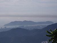
The Penang Strait separates Penang Island from the Malay Peninsula to the east. It connects with the Strait of Malacca to the north and south.
The strait can also be further divided into the North Channel and the South Channel. The North Channel refers to the body of water north of the northeastern promontory of Penang Island, where George Town is situated, whereas the South Channel covers the body of water south of that promontory.
-
 The North Channel off the northern coastline of George Town
 -
 The South Channel along the eastern shoreline of George Town
 -
 Jerejak Island, the largest island within the Penang Strait


The rivers that flow into the Penang Strait are listed as follows.
- Pinang River
- Gelugor River
- Bayan Lepas River
- Perai River
- Muda River
- Kerian River
- Juru River
- Jawi River
Islands edit
A handful of islands and islets lie within the South Channel of the Penang Strait. The largest of all is Jerejak Island, located off the southeastern coast of Penang Island. The largely forested island was once the site of a leper asylum, which was then converted into a maximum security prison before its eventual closure in 1993.[4]
Other islets within the strait are Aman Island and Gedung Island, both of which are located off the southern coast of Seberang Perai. Man-made islets were also created during the construction of the Penang Bridge in the 1980s.
History edit
Ever since the establishment of George Town in 1786, the Penang Strait has served as an important shipping route within the State of Penang. Up until the 1970s, the main harbour facilities were situated at Weld Quay in George Town. The reclamation of Weld Quay in the late 19th century allowed larger ships to dock off the city's waterfront, as the depth of the seas off Weld Quay was deeper.[5]
In 1974, the Port of Penang's cargo facilities were shifted to Butterworth across the strait.[3][6][7] Thus, cargo and container shipping are mainly handled in Butterworth, while Swettenham Pier in George Town continues to receive cruise ships to this day.[2][8] In 2015 alone, Swettenham Pier recorded 145 port calls, the highest in Malaysia.[9] Meanwhile, Butterworth's port facilities handled more than 1.2 million TEU of cargo in 2013, making it one of the busiest harbours in the country.[10]
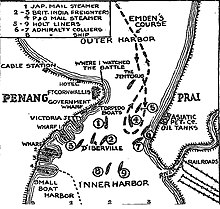
The Penang Strait was also the scene where the initial shots of the Battle of Penang were fired on 28 October 1914. The Imperial German Navy cruiser, SMS Emden, sailed into the strait disguised as a British ship before shelling and torpedoing the Imperial Russian Navy cruiser, Zhemchug. SMS Emden then sailed northwest towards the Malacca Straits, sinking another French warship along the way.
Towards the end of World War II, the Penang Strait was also mined by the Allied forces, using air-dropped mines to impede Japanese merchant shipping.[11]
On 17 January 2010, a dragon boat tragedy occurred when the strong currents resulted in a boat collision, capsizing a dragon boat and killing 6 paddlers on board. The incident raised concerns by several officers, especially Shamsir Mohamed, officer of the Marine Department (northern region) and Lai Chew Hock, chairman of the Penang Dragon Boat Association, regarding the suitability for conducting water sports in the Penang Straits. Shamsir cited busy traffic, unpredictable weather, and strong currents for his concerns, while Chew Hock claimed the area was unsuitable for any water sports activities due to debris from fishing boats and strong currents.[12] However, Lim Choo Hooi, chairman of Penang Forward Sports Club, refuted the claim, saying that neither the wave tides nor the monsoon season posed a problem for training sessions. Coaches would need to check sea and weather conditions prior to conducting training sessions. He also said that the tragedy site was protected from tsunamis and strong waves and had been used for training for three years, making it one of the safest stretches of public shoreline.[13]
Transportation and Infrastructure edit
  |
Bridges edit
Two bridges now traverse the Penang Strait - the Penang Bridge and the Second Penang Bridge. The Penang Bridge, completed in 1985, connects Perai on the mainland with the suburb of Gelugor on Penang Island. In 2014, the Second Penang Bridge further south was opened for public use, thereby substituting the Penang Bridge as the longest bridge in Southeast Asia. The Second Penang Bridge runs between Batu Kawan on the mainland and Batu Maung on the island.
To bolster Penang's electricity grid, Tenaga Nasional Berhad (TNB) initiated a RM500 million cross-straits electric grid project in 2022. This significant investment aims to deliver a substantial 2,000 megawatts (MW) of power from the national grid to the island. The project encompasses an 8.5-kilometer-long monopole transmission line, while six of the 31 towers will boast a unique betel nut design, making them a visually striking landmark alongside the iconic Penang Bridge.[14]
-
 The 13.5 kilometre-long Penang Bridge traverses the South Channel between Gelugor on Penang Island and Perai in the mainland.
 -

-
 A Penang Ferry crossing the Penang Strait.
 -
 TNB monopoles under construction as of 2024 seen from Penang Bridge


Ferry edit
In addition to the two bridges, Penang ferry service is another transportation link between Penang Island and the mainland (Penang Sentral). Unlike the two bridges, the ferry service operates out of a terminal within the heart of George Town, offering a direct link into the city centre for those entering from the mainland.

References edit
- ^ Ebook Sailing guide: Strait of Malacca (East). Sea-Seek. 2016.
- ^ a b "Is Penang's tourism on the right track?". Penang Monthly. 2015-10-01. Archived from the original on 2016-10-26. Retrieved 2017-02-19.
- ^ a b "The Changing Harbour Front". Penang Monthly. 2016-07-01. Archived from the original on 2017-02-20. Retrieved 2017-03-01.
- ^ "Jerejak steeped in Malaysia's migrant history, says researcher". Free Malaysia Today. Retrieved 2017-05-16.
- ^ "Where the Sea Meets the City is Where the World Meets Penang". Penang Monthly. 2016-07-01. Archived from the original on 2017-02-20. Retrieved 2017-03-01.
- ^ "The Mainland Awakens". Penang Monthly. 2016-09-01. Archived from the original on 2017-02-11. Retrieved 2017-03-01.
- ^ Natacha Aveline-Dubach, Sue-Ching Jou, Hsin-Huang Michael Hsiao (2014). Globalization and New Intra-Urban Dynamics in Asian Cities. Taiwan: Taiwan Resource Center for Chinese Studies. ISBN 9789863500216.
{{cite book}}: CS1 maint: multiple names: authors list (link) - ^ "Penang ready for 17,000 cruise ship passengers". www.thesundaily.my. Retrieved 2017-03-01.
- ^ "Penang records country's second-most cruise arrivals last year". 2016-06-07. Retrieved 2017-03-01.
- ^ "Container Services". Port of Penang. Archived from the original on 2017-11-07. Retrieved 2017-03-01.
- ^ Paul H. Kratoska (1998). The Japanese Occupation of Malaya: A Social and Economic History. C. Hurst & Co. Publishers. pp. 296–. ISBN 978-1-85065-284-7.
- ^ "Multiple blunders blamed for dragon boat tragedy". The Star. 2010-01-19. Retrieved 2020-08-07.
- ^ "Dragon boat run carried out at students' request, inquest told". The Star. 2010-11-04. Retrieved 2020-08-07.
- ^ Dermawan, Audrey (2022-09-15). "TNB's RM500 million project set to boost Penang's economic growth [NSTTV] | New Straits Times". NST Online. Retrieved 2024-02-28.
Literature edit
- Bjorn Kjerfve "Oceanographic Observations and Numerical Modeling of Circulation and Dispersion in Penang Strait, Malaysia." Belle W. Baruch Institute for Marine Biology and Coastal Research, University of South Carolina