


Summary
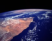
A peninsula[1][2] is a landform that extends from a mainland and is surrounded by water on most sides.[3][4][5] Peninsulas exist on all continents.[6][2] The largest peninsula in the world is the Arabian Peninsula.[7][8]


Etymology edit
Peninsula derives from Latin paeninsula, which is translated as 'peninsula'. Paeninsula itself was derived from paene 'almost', and insula 'island', or together, 'almost an island'.[3] The word entered English in the 16th century.[3]
Definitions edit
A peninsula is generally defined as a piece of land surrounded on most sides by water.[5][9]
A peninsula may be bordered by more than one body of water, and the body of water does not have to be an ocean or a sea.[10] A piece of land on a very tight river bend or one between two rivers is sometimes said to form a peninsula, for example in the New Barbadoes Neck in New Jersey, United States.[5] A peninsula may be connected to the mainland via an isthmus, for example, in the Isthmus of Corinth which connects to the Peloponnese peninsula.[11]
Formation and types edit
Peninsulas can be formed from continental drift, glacial erosion, glacial meltwater, glacial deposition, marine sediment, marine transgressions, volcanoes, divergent boundaries or river sedimentation.[12] More than one factor may play into the formation of a peninsula. For example, in the case of Florida, continental drift, marine sediment, and marine transgressions were all contributing factors to its shape.[13]
Glaciers edit
In the case of formation from glaciers (e.g., the Antarctic Peninsula or Cape Cod), peninsulas can be created due to glacial erosion, meltwater or deposition.[14] If erosion formed the peninsula, softer and harder rocks were present, and since the glacier only erodes softer rock, it formed a basin.[14] This may create peninsulas, and occurred for example in the Keweenaw Peninsula.[14]
In the case of formation from meltwater, melting glaciers deposit sediment and form moraines, which act as dams for the meltwater.[14] This may create bodies of water that surround the land, forming peninsulas.[14]
If deposition formed the peninsula, the peninsula was composed of sedimentary rock, which was created from a large deposit of glacial drift.[15][16] The hill of drift becomes a peninsula if the hill formed near water but was still connected to the mainland, for example during the formation of Cape Cod about 23,000 years ago.[17][18]
Others edit
In the case of formation from volcanoes, when a volcano erupts magma near water, it may form a peninsula (e.g., the Alaskan Peninsula).[15] Peninsulas formed from volcanoes are especially common when the volcano erupts near shallow water.[19] Marine sediment may form peninsulas by the creation of limestone.[20] A rift peninsula may form as a result of a divergent boundary in plate tectonics (e.g. the Arabian Peninsula),[21][22] while a convergent boundary may also form peninsulas (e.g. Gibraltar or the Indian subcontinent).[23] Peninsulas can also form due to sedimentation in rivers. When a river carrying sediment flows into an ocean, the sediment is deposited, forming a delta peninsula.[24]
Marine transgressions (changes in sea level) may form peninsulas, but also may affect existing peninsulas. For example, the water level may change, which causes a peninsula to become an island during high water levels.[25] Similarly, wet weather causing higher water levels make peninsulas appear smaller, while dry weather make them appear larger.[26] Sea level rise from global warming will permanently reduce the size of some peninsulas over time.[27]
Uses edit
Peninsulas are noted for their use as shelter for humans and Neanderthals.[28] The landform is advantageous because it gives hunting access to both land and sea animals.[28]They can also serve as markers of a nation's borders.[29]
List of the largest peninsulas in the world edit
See also edit
References edit
- ^ (from Latin paeninsula; from paene 'almost', and insula 'island') "peninsula". The American Heritage Dictionary of the English Language (5th ed.). HarperCollins. Retrieved 2016-05-01.
- ^ a b Nadeau 2006, p. 5.
- ^ a b c HMH 2004, p. 216.
- ^ "Definition of peninsula". Cambridge Dictionaries Online. Cambridge University Press. Retrieved 1 May 2016.
- ^ a b c Kersey, Paul (23 July 2021). "What is a Peninsula?". Infoplease. Retrieved 2022-04-30.
- ^ "peninsula". National Geographic Society. 2011-01-21. Retrieved 2022-04-30.
- ^ Mis 2009, p. 20.
- ^ Niz 2006, p. 19.
- ^ "list of peninsulas". Britannica. Retrieved 2022-04-30.
- ^ Heos 2010, p. 15.
- ^ Heos 2010, p. 9.
- ^ Mis 2009, p. 6.
- ^ Heos 2010, p. 8.
- ^ a b c d e Heos 2010, p. 31.
- ^ a b Nadeau 2006, p. 6.
- ^ Heos 2010, p. 32–33.
- ^ Nadeau 2006, p. 9.
- ^ Wyckoff 1999, p. 328.
- ^ Heos 2010, p. 44.
- ^ Heos 2010, p. 21–23.
- ^ Nadeau 2006, p. 10.
- ^ Heos 2010, pp. 43–44.
- ^ Heos 2010, p. 40.
- ^ Nadeau 2006, p. 13.
- ^ Niz 2006, p. 7.
- ^ Niz 2006, p. 13.
- ^ Nadeau 2006, p. 21.
- ^ a b Heos 2010, p. 45.
- ^ Heos 2010, p. 48.
- ^ Encyclopædia Britannica: "Arabia".
- ^ Tsvetkov, Kaloyan; Traykov, Tony (July 2023). "Polytheistic and Syncretic Religious Beliefs in Southeast Asia - Nature, Features, and Geographical Distribution". ResearchGate. Archived from the original on Jan 8, 2024.
- ^ "Explore India - Mineral Scenario of the States of India" (PDF). Government of India - Ministry of Mines. Jan 2010. Archived (PDF) from the original on Mar 14, 2024.
- ^ Misachi, John (2021-09-01). "Labrador Peninsula". WorldAtlas. Archived from the original on Jan 8, 2024.
- ^ Seferoglu, S. Sadi. "Turkey at a Glance - Geography". Türkiye on the Web. Archived from the original on Jan 8, 2024.
- ^ Encyclopædia Britannica: "Scandinavian Peninsula".
- ^ Article bay (Jan 17, 2023). "Africa's largest peninsula has always been on the target of world powers. Where is it actually located?". Medium. Archived from the original on 27 Mar 2024.
- ^ Encyclopædia Britannica: "Balkans".
- ^ Misachi, John (2021-02-11). "Iberian Peninsula". WorldAtlas. Archived from the original on Jan 8, 2024.
- ^ Davies, Bethan (2020-06-22). "Antarctic Peninsula Ice Sheet". AntarcticGlaciers.org. Archived from the original on Nov 28, 2022.
- ^ Encyclopædia Britannica: "Taymyr Peninsula".
- ^ Encyclopædia Britannica: "Kamchatka Peninsula".
Bibliography edit
- Heos, Bridget (2010). The creation of peninsulas (1st ed.). New York: Rosen Pub. ISBN 978-1-4358-5301-0. OCLC 277466133.
- Mis, Melody S. (2009). Exploring peninsulas (1st ed.). New York: PowerKids Press. ISBN 978-1-4358-2711-0. OCLC 230802567.
- Nadeau, Isaac (2006). Peninsulas (1st ed.). New York: Rosen Pub. Group's PowerKids Press. ISBN 1-4042-3125-0. OCLC 57068647.
- Niz, Ellen Sturm (2006). Peninsulas. Mankato, Minn.: Capstone Press. ISBN 0-7368-4308-6. OCLC 57366483.
- Word Histories and Mysteries: From Abracadabra to Zeus. Houghton Mifflin Harcourt. 2004. ISBN 978-0547350271. OCLC 55746553.
- Wyckoff, Jerome (1999). Reading the earth : landforms in the making. Mahwah, NJ: Adastra West, Inc. ISBN 0-9674075-0-8. OCLC 43274886.
External links edit
 The dictionary definition of peninsula at Wiktionary