


Summary
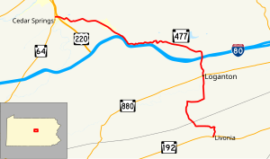
Pennsylvania Route 477 (PA 477) is a 17.7-mile-long (28.5 km) state highway located in Centre and Clinton counties in Pennsylvania. The southern terminus is at PA 192 in Miles Township. The northern terminus is at PA 64 near Mill Hall.
Pennsylvania Route 477 | ||||
|---|---|---|---|---|
 | ||||
| Route information | ||||
| Maintained by PennDOT | ||||
| Length | 17.681 mi[1] (28.455 km) | |||
| Major junctions | ||||
| South end | ||||
| North end | ||||
| Location | ||||
| Country | United States | |||
| State | Pennsylvania | |||
| Counties | Centre, Clinton | |||
| Highway system | ||||
| ||||

Route description edit

PA 477 begins at an intersection with PA 192 in the community of Livonia in Miles Township, Centre County, heading north on two-lane undivided Apple Ridge Road. The road heads across Nittany Mountain in the Bald Eagle State Forest, turning to the west before heading northwest.[2][3] The route heads into Greene Township in Clinton County and heads north on Bull Run Road, leaving the state forest and heading through more wooded areas with some fields. PA 477 turns east onto West Winter Road and heads through agricultural areas in the Sugar Valley. The route turns north onto South Mill Street and passes through more rural areas before entering the borough of Loganton. Here, the road passes homes and crosses PA 880, becoming North Mill Street. PA 477 heads back into Greene Township and passes through a gap in forested Sugar Valley Mountain. The road reaches an interchange with I-80 and passes a few businesses, turning west onto Long Run Road and heading through Rosecrans.[2][4]
The route runs west-northwest through farmland with occasional residences before heading into another section of the Bald Eagle State Forest. PA 477 heads into Lamar Township and runs a short distance to the north of I-80. The road turns northwest and heads away from the interstate as it passes through wooded residential areas and runs through Rote. Following this, the route winds west through farmland and woodland with some homes. The road passes through the residential community of Salona before crossing Fishing Creek and reaching an interchange with the US 220 freeway. A short distance later, PA 477 ends at an intersection with PA 64.[2][4]
Major intersections edit
| County | Location | mi[2] | km | Destinations | Notes |
|---|---|---|---|---|---|
| Centre | Miles Township | 0.0 | 0.0 | Southern terminus | |
| Clinton | Loganton | 6.0 | 9.7 | ||
| Greene Township | 7.2 | 11.6 | Exit 185 (I-80) | ||
| Lamar Township | 17.5 | 28.2 | Exit 107 (US 220) | ||
| 17.6 | 28.3 | Northern terminus | |||
| 1.000 mi = 1.609 km; 1.000 km = 0.621 mi | |||||
See also edit
 U.S. Roads portal
 Pennsylvania portal
References edit
- ^ "Pennsylvania state roads". Pennsylvania Spatial Data Access. Pennsylvania Department of Transportation. 2013. Retrieved March 14, 2013.
- ^ a b c d Google (July 9, 2011). "overview of Pennsylvania Route 477" (Map). Google Maps. Google. Retrieved July 9, 2011.
- ^ Centre County, Pennsylvania Highway Map (PDF) (Map). PennDOT. 2011. Archived from the original (PDF) on August 29, 2011. Retrieved May 27, 2011.
- ^ a b Clinton County, Pennsylvania Highway Map (PDF) (Map). PennDOT. 2011. Archived from the original (PDF) on November 6, 2011. Retrieved July 9, 2011.
External links edit
- Pennsylvania Highways: PA 477