


Summary
Peralasseri is a census town and Panchayat headquarters in Kannur district in the Indian state of Kerala, situated on the Kannur-Kuthuparamba State Highway 38 (Kerala), 12 km from Kannur city, on the bank of Anjarakandy river.[1]
Peralasseri | |
|---|---|
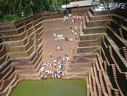 Temple Pond in Peralassery | |
 Peralasseri Location in Kerala, India  Peralasseri Peralasseri (India) | |
| Coordinates: 11°50′57″N 75°29′10″E / 11.849140°N 75.486010°E | |
| Country | |
| State | Kerala |
| District | Kannur |
| Taluk | Kannur |
| Government | |
| • Body | Peralasseri Grama Panchayat |
| Area | |
| • Total | 10.76 km2 (4.15 sq mi) |
| Population (2011) | |
| • Total | 16,821 |
| • Density | 1,600/km2 (4,000/sq mi) |
| Languages | |
| • Official | Malayalam, English |
| Time zone | UTC+5:30 (IST) |
| ISO 3166 code | IN-KL |
Geography edit
Peralasseri is 14 kilometres (8.7 mi) from the district headquarters Kannur. The nearest town and railway stations are Thalassery which is 14 km (8.7 mi) and Kannur which is 15 km (9.3 mi) away. In olden days the place was known as Peru+VaLa+Sery "Great Fertile Domicile, which fact can be confirmed by a visit to the place. The Place is surrounded by 4 panchayats: Kadambur, vengad, Anjarakandi, Pinarayi. The Panchayath Office is located near Peralassery Subrahmanya Temple.
Demographics edit
As of 2011 Census, Peralasseri had a population of 16,821 which constitutes 7,687 (45.7%) males and 9,134 (54.3%) females. Peralasseri census town spreads over an area of 10.76 km2 (4.15 sq mi) with 3,830 families residing in it. The male female sex ratio was 1,188 higher than state average of 1,084. In Peralasseri, 10.3% of the population is under 6 years of age. Peralasseri had an overall literacy of 97.9% higher than state average of 94%. The male literacy stands at 98.8% and female literacy was 97%.[2]
Religion edit
As of 2011 census, Peralasseri census town had total population of 16,821, which constitutes 79.4% Hindus, 20.4% Muslims and 0.2% others.[3]
Highways and Bridges edit
Kannur - Kuthuparamba state highway is passing through this place. Peralasseri is 15 km away from Kannur town and about 14 km away from the Kannur international airport near Mattanur.

The hanging bridge of Peralasseri is a notable tourist attraction.[citation needed] Built across the Anjarakandy river, this is one of the few hanging bridges in Kannur district.

Govt Offices edit
- Peralassery Grama Panchayath Office
- Mundaloor Post office
- Makreri Village Office
- KSEB Electrical Section Office - Peralassery
- Kerala Water Authority Asst Engineer Office and Asst Executive Engineer Office.
- BSNL Telephone Exchange - Peralassery
A.K.G. High School edit
Peralasseri A.K.G. Smaraka Govt. Higher Secondary School is an old school of Peralasseri town. The school is situated near the Peralasseri Temple at Mundalloor on the Kannur road. The school is known for good results and one of the good government school in Kerala[citation needed]
Medical Help edit
- AKG Smaraka Co- op hospital
- Govt. Ayurvedic Dispensary
Schools and Colleges edit
- AKG Smaraka Govt.Higher secondary school
- Viswabharathi Public School, Mavilayi
Banks edit
- Peralasseri Service Co-op Bank - Main Branch
- Central Bank Of India - Peralasseri Branch
- Mownachery Co-op Rural Bank - Peralasseri Branch
- Canara Bank - Peralasseri Branch
Famous Religious Centres edit
- Peralasseri Subrahmanya Temple
- Sri Peralasseri Siva Temple :Kunhimooloth
- Peralasseri Naroth Mahavishnu Temple
- Rangoth Bhagavathy Temple
- Makrery Subrahmanya-Hanuman Temple
- Mahavishnu Sivakshetram Aivarkulam
- Mundaloor Rifayi Masjid[citation needed]
Other Landmarks edit
- AKG vaayanashala
- Mundaloor Mueenul Islam Sabha Secondary Madrassa.
- Peralassery Markaz Yatheem Khana
- Chirathukandi Azhikkodan club
- AKG Memorial
Industries edit
Raidco Curry Powder Factory - Moonnu Periya
Peralasseri Panchayath Mini Industrial Estate
Transportation edit
The national highway passes through Kannur town. Goa and Mumbai can be accessed on the northern side and Cochin and Thiruvananthapuram can be accessed on the southern side. The road to the east of Iritty connects to Mysore and Bangalore. The nearest railway station is Kannur on Mangalore-Palakkad line. Trains are available to almost all parts of India subject to advance booking over the internet. There are airports at Mattanur, Mangalore and Calicut. All of them are international airports but direct flights are available only to Middle Eastern countries.
Notable Persons edit
- A K Gopalan - Politician, Social Reformer
- C.H Kunjappa - Writer
- Sukala Suresh - Artist
References edit
- ^ "Census of India 2001: Data from the 2001 Census, including cities, villages and towns (Provisional)". Census Commission of India. Archived from the original on 16 June 2004. Retrieved 1 November 2008.
- ^ Kerala, Directorate of Census Operations. District Census Handbook, Kannur (PDF). Thiruvananthapuram: Directorateof Census Operations,Kerala. p. 192,193. Retrieved 14 July 2020.
- ^ "Religion – Kerala, Districts and Sub-districts". Census of India 2011. Office of the Registrar General.