


Summary
Pertek (from Armenian: Բերդակ, romanized: Berdak, Kurdish: Pêrteg[1]) is a town and seat of Pertek District in Tunceli Province, Turkey.[2] It had a population of 6,365 in 2021 and is populated by Kurds and Turks.[3][4] The mayor is Ruhan Alan from the Republican People's Party (CHP).[5]
Pertek | |
|---|---|
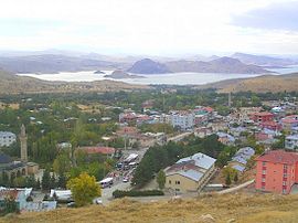 View of Pertek, the 16th century Celebi Ali mosque is visible in the left of the image. Lake Keban is in the backgroudn. | |
 Pertek Location in Turkey | |
| Coordinates: 38°52′01″N 39°19′30″E / 38.86694°N 39.32500°E | |
| Country | Turkey |
| Province | Tunceli |
| District | Pertek |
| Government | |
| • Mayor | Ruhan Alan (CHP) |
| Population (2021) | 6,365 |
| Time zone | UTC+3 (TRT) |
| Website | www |
The neighborhoods of the town are Camiikebir, Derebaşı, İstiklal, Kaledibi, Soğukpınar.[2]
History edit
The area of Pertek was ruled by different empires in its history. In the medieval period such as the Armenians and Byzantines before being taken over by different Islamic dynasties after the 11th century. Later it became part of the Ilkhanids and others and finally became part of the Ottoman Empire in the early 16th century.
During the Ottoman period Pertek was a hereditary Kurdish sanjak.[6] The old town of Pertek (Eski Pertek) was located near the citadel but was abandoned in 1838 and moved to its current location.[6] Armenian sources state that about 180 Armenians still lived in the old town (Eski Pertek) up until the early 1900s despite the rising water levels of the Euphrates river.[7] After 1889, it was fully incorporated into the Mamuretul-aziz Vilayet as a nahiye district of the Charsanjak kaza within the sanjak of Dersim.[8]
According to the 1881 Ottoman census, there were 6 neighborhoods of Pertag town - 1154 total males (966 Muslim, 188 Armenian Apostolic) in 520 households. The general district had 23 villages of Pertag district - 127 total males (943 Muslim, 184 Armenian Apostolic) in 552 households. Females were often undercounted or entirely disregarded from census counts.[7]
As a result of the construction of the Keban Dam, the Pertek district experienced the submerging of a number of its district's villages. Some of the settlements submerged were Eski Pertek, Borkin, Korluca (Til), Balan, Deşt, Zahuran, Beroç, Karameşe (Tezikan) [partially submerged], Tuzbaşı (Nisirto) [abandoned].[9]
Historic monuments edit
There are two historic Ottoman mosques in Pertek.[6] The Baysungur mosque (16th century)[6] and Celebi Ali mosque (16th century).[6] The mosques were later dismantled and moved from the site of the old town to protect them from the rising water shore of the Lake Keban.[6] The Pertek Castle is located on an Island.[6] There are other historic sights in the nearby area. The village of Sağman has a ruined citadel with a 16th-century mosque, tomb and tekke built by the Kurdish sanjak bey Keykusrav.[6]
-
 The Pertek Castle is located on an island since the building of the Keban Dam.

Archaeology edit
In August 2022, archaeologists led by Kenan Öncel announced that they had discovered a child skeleton in an oval-shaped pit in Tozkoparan Mound. They also revealed terracotta potteries, obsidians, bones, stone tools and arrowheads. In order to determine the skeleton's diet and age-at-death, researchers are planning to trace the diseases left in the bones.[10][11]
References edit
- ^ Avcıkıran, Adem (2009). Kürtçe Anamnez Anamneza bi Kurmancî (in Turkish and Kurdish). p. 55.
- ^ a b "Türkiye Mülki İdare Bölümleri Envanteri". T.C. İçişleri Bakanlığı (in Turkish). Retrieved 19 December 2022.
- ^ "Address-based population registration system (ADNKS) results dated 31 December 2021" (XLS) (in Turkish). TÜİK. Retrieved 30 January 2023.
- ^ Andrews, Peter; Benninghaus, Rüdiger (2002). Ethnic Groups in the Republic of Turkey: Supplement and Index. p. 64. ISBN 9783895002298.
- ^ Şafak, Yeni (2019-06-12). "Tunceli Pertek Seçim Sonuçları – Pertek Yerel Seçim Sonuçları". Yeni Şafak (in Turkish). Retrieved 2019-12-06.
- ^ a b c d e f g h Sinclair, T.A. (1989). Eastern Turkey: An Architectural & Archaeological Survey, Volume I. Pindar Press. pp. 77–83–84–85–102–103–158. ISBN 9780907132325.
- ^ a b "Maps | Vilayet of Mamuratul Aziz-Harput | Sandjak of Dersim | Locale | Demography (Part III) :: Houshamadyan - a project to reconstruct Ottoman Armenian town and village life".
- ^ Sezen, Tahir. 2017. Osmanlı yer adları.
- ^ "Keban barajı ile neler kaybettik?" (PDF). Archived from the original (PDF) on 11 August 2021. Retrieved 11 August 2021.
- ^ "Child skeleton among findings in Tunceli excavations". Hürriyet Daily News. Retrieved 2022-08-11.
- ^ YILDIRIM/TUNCELİ, (DHA), Serhat Ozan. "Tunceli'de kazı çalışmasında bulundu: 5 bin 500 yıllık..." www.hurriyet.com.tr (in Turkish). Retrieved 2022-08-11.