
KNOWPIA
WELCOME TO KNOWPIA

Piandimeleto 
Summary
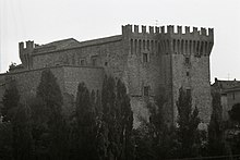
Piandimeleto is a comune (municipality) in the Province of Pesaro e Urbino in the Italian region Marche, located about 90 kilometres (56 mi) west of Ancona and about 45 kilometres (28 mi) southwest of Pesaro.
Piandimeleto | |
|---|---|
| Comune di Piandimeleto | |
 | |
 Coat of arms | |
Location of Piandimeleto .mw-parser-output .locmap .od{position:absolute}.mw-parser-output .locmap .id{position:absolute;line-height:0}.mw-parser-output .locmap .l0{font-size:0;position:absolute}.mw-parser-output .locmap .pv{line-height:110%;position:absolute;text-align:center}.mw-parser-output .locmap .pl{line-height:110%;position:absolute;top:-0.75em;text-align:right}.mw-parser-output .locmap .pr{line-height:110%;position:absolute;top:-0.75em;text-align:left}.mw-parser-output .locmap .pv>div{display:inline;padding:1px}.mw-parser-output .locmap .pl>div{display:inline;padding:1px;float:right}.mw-parser-output .locmap .pr>div{display:inline;padding:1px;float:left}html.skin-theme-clientpref-night .mw-parser-output .od,html.skin-theme-clientpref-night .mw-parser-output .od .pv>div,html.skin-theme-clientpref-night .mw-parser-output .od .pl>div,html.skin-theme-clientpref-night .mw-parser-output .od .pr>div{background:#000;color:#fff}html.skin-theme-clientpref-night .mw-parser-output .locmap{filter:grayscale(0.6)}@media(prefers-color-scheme:dark){html.skin-theme-clientpref-os .mw-parser-output .locmap{filter:grayscale(0.6)}html.skin-theme-clientpref-os .mw-parser-output .od,html.skin-theme-clientpref-os .mw-parser-output .od .pv>div,html.skin-theme-clientpref-os .mw-parser-output .od .pl>div,html.skin-theme-clientpref-os .mw-parser-output .od .pr>div{background:#000;color:#fff}}  Piandimeleto Location of Piandimeleto in Italy  Piandimeleto Piandimeleto (Marche) | |
| Coordinates: 43°44′N 12°25′E / 43.733°N 12.417°E | |
| Country | Italy |
| Region | Marche |
| Province | Pesaro e Urbino (PU) |
| Government | |
| • Mayor | Veronica Magnani |
| Area | |
| • Total | 39.9 km2 (15.4 sq mi) |
| Elevation | 319 m (1,047 ft) |
| Population | |
| • Total | 2,137 |
| • Density | 54/km2 (140/sq mi) |
| Demonym | Pianmeletesi |
| Time zone | UTC+1 (CET) |
| • Summer (DST) | UTC+2 (CEST) |
| Postal code | 61026 |
| Dialing code | 0722 |
| Patron saint | St. Blaise |
| Saint day | 3 February |
| Website | Official website |
Piandimeleto borders the following municipalities: Belforte all'Isauro, Carpegna, Frontino, Lunano, Macerata Feltria, Pietrarubbia, Sant'Angelo in Vado, Sassocorvaro Auditore, Sestino, Urbino. Its territory is included in the Sasso Simone and Simoncello Regional Park. The Foglia river flows near the town.
References edit
- ^ "Superficie di Comuni Province e Regioni italiane al 9 ottobre 2011". Italian National Institute of Statistics. Retrieved 16 March 2019.
- ^ All demographics and other statistics: Italian statistical institute Istat.
- ^ "Popolazione Residente al 1° Gennaio 2018". Italian National Institute of Statistics. Retrieved 16 March 2019.
External links edit
- Official website