
KNOWPIA
WELCOME TO KNOWPIA

Pica d'Estats 
Summary
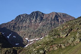
Pica d'Estats (or The States Peak) (Catalan: Pica d'Estats, French: Pic d'Estats) is a 3,143-metre-high (10,312 ft) mountain in the Montcalm Massif, Pyrenees.[1] on the Spanish–French border, and is the highest mountain in Catalonia.
| Pica d'Estats | |
|---|---|
| Pic d'Estats | |
 | |
| Highest point | |
| Elevation | 3,143 m (10,312 ft) |
| Prominence | 1,277 m (4,190 ft) |
| Coordinates | 42°40′02″N 01°23′50″E / 42.66722°N 1.39722°E |
| Geography | |
 Pica d'Estats Pyrenees | |
| Location | Pallars Sobirà, Catalonia, Spain Ariège, Occitania, France |
| Parent range | Pyrenees |
| Climbing | |
| First ascent | 1864 by Henry Russell and Jean-Jacques Denjean |
This mountain is included in the Parc Natural de l'Alt Pirineu.

Summits edit
The summit is located between the Catalan municipality of Alins in Pallars Sobirà and the French district of Ariège. It comprises three peaks, all lying close to each other:
- Central peak (3,143 m)[2]
- Western peak, or Pic de Verdaguer, (3,131 m)
- Eastern peak, or Punta Gabarró, (3,115 m)
This eastern peak is the geodesic vertex. The ridge runs north-northwest to southeast along the Spanish–French border.