


Summary
Piedras del Tunjo (Spanish for "Tunjo Rocks") is an important archaeological park established on a natural rock shelter 40 kilometres (25 mi) west of Bogotá in the municipality of Facatativá.
 Centre of the Piedras del Tunjo Archaeological Park | |
 Location within Colombia | |
| Location | Facatativá, Cundinamarca |
|---|---|
| Region | Altiplano Cundiboyacense |
| Coordinates | 4°48′59.59″N 74°20′45.59″W / 4.8165528°N 74.3459972°W |
| Altitude | 2,611 m (8,566 ft)[1] |
| Type | Rock art |
| Part of | Pre-Muisca sites |
| History | |
| Abandoned | Spanish conquest |
| Periods | Herrera Period-Late Muisca |
| Cultures | Muisca |
| Satellite of | Bacatá |
| Site notes | |
| Archaeologists | Diego Martínez Celis Álvaro Botiva Contreras Guillermo Muñoz Castiblanco |
| Condition | Threatened |
| Public access | Yes |
Description edit

In the Late Pleistocene, the site used to be the shore of a large lake flooding the Bogotá savanna; Lake Humboldt[citation needed] .8 It was used by the Muisca rulers as a refuge during the time of the Spanish conquest. The site is one of the possible places where the soldiers of Gonzalo Jiménez de Quesada killed the ruling zipa Tisquesusa in April 1537.
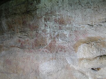
The rocks are covered with pictographs made by Muisca artists on rocks of the Guadalupe Group.[2] Their age has not been confirmed. The area of the park used to be an hacienda, property of a wealthy family since colonial times. It was nationalized in 1946 to establish the park.
Destruction of the ancient pictographs edit
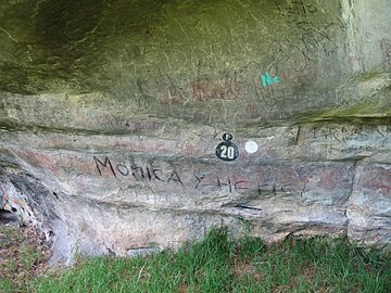
Decades of government negligence and lack of policies for the protection of archaeological heritage have resulted in the destruction of most of the ancient paintings.[citation needed]
Gallery edit
-
 Rock face with petroglyphs
 -
 Petroglyph on one of the rocks
 -
 Vandalised petroglyph


See also edit
References edit
Bibliography edit
- Ulloa, Carlos E; Erasmo Rodríguez, and Jorge E. Acosta. 1998. Plancha 227 - Geología de La Mesa - 1:100,000, 1. INGEOMINAS.
External links edit
- (in Spanish) Restoration and training on pictographs - a Colombian Case (Archaeological park of Facatativá) - Rupestreweb
- (in Spanish) To the rescue of the archaeological park of Facatativá - Rupestreweb
Further reading edit
- Martínez Celis, Diego, and Álvaro Botiva Contreras. 2004a. Manual de arte rupestre de Cundinamarca - Manual of rock art of Cundinamarca, 1-60. ICANH.
- Martínez Celis, Diego, and Álvaro Botiva Contreras. 2004b. Introducción al arte rupestre, 1-28. ICANH.
- Muñoz Castiblanco, Guillermo. 2013. Catalogación, registro sistemático y diagnóstico de las pinturas rupestres del Parque Arqueológico de Facatativá, 1-89. GIPRI.
- Muñoz Castiblanco, Guillermo. 2006. Pinturas rupestres en el Altiplano Cundiboyacense, Colombia - concentración y diversidad en la Sabana de Bogotá: Municipio de Suacha-Sibaté Cundinamarca - Rock paintings on the Altiplano Cundiboyacense, Colombia - concentration and diversity on the Bogotá savanna: municipality of Soacha-Sibaté, Cundinamarca, 1-22.