
KNOWPIA
WELCOME TO KNOWPIA

Pierrelaye 
Summary
Pierrelaye (French pronunciation: [pjɛʁlɛ] ⓘ) is a commune in the Val-d'Oise department in Île-de-France in northern France. Pierrelaye station has rail connections to Pontoise and Paris.
Pierrelaye | |
|---|---|
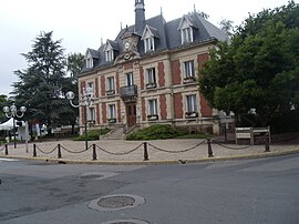 The town hall of Pierrelaye | |
Location of Pierrelaye .mw-parser-output .locmap .od{position:absolute}.mw-parser-output .locmap .id{position:absolute;line-height:0}.mw-parser-output .locmap .l0{font-size:0;position:absolute}.mw-parser-output .locmap .pv{line-height:110%;position:absolute;text-align:center}.mw-parser-output .locmap .pl{line-height:110%;position:absolute;top:-0.75em;text-align:right}.mw-parser-output .locmap .pr{line-height:110%;position:absolute;top:-0.75em;text-align:left}.mw-parser-output .locmap .pv>div{display:inline;padding:1px}.mw-parser-output .locmap .pl>div{display:inline;padding:1px;float:right}.mw-parser-output .locmap .pr>div{display:inline;padding:1px;float:left}html.skin-theme-clientpref-night .mw-parser-output .od,html.skin-theme-clientpref-night .mw-parser-output .od .pv>div,html.skin-theme-clientpref-night .mw-parser-output .od .pl>div,html.skin-theme-clientpref-night .mw-parser-output .od .pr>div{background:#000;color:#fff}html.skin-theme-clientpref-night .mw-parser-output .locmap{filter:grayscale(0.6)}@media(prefers-color-scheme:dark){html.skin-theme-clientpref-os .mw-parser-output .locmap{filter:grayscale(0.6)}html.skin-theme-clientpref-os .mw-parser-output .od,html.skin-theme-clientpref-os .mw-parser-output .od .pv>div,html.skin-theme-clientpref-os .mw-parser-output .od .pl>div,html.skin-theme-clientpref-os .mw-parser-output .od .pr>div{background:#000;color:#fff}}  Pierrelaye  Pierrelaye | |
| Coordinates: 49°01′24″N 2°09′03″E / 49.0233°N 2.1508°E | |
| Country | France |
| Region | Île-de-France |
| Department | Val-d'Oise |
| Arrondissement | Argenteuil |
| Canton | Taverny |
| Intercommunality | CA Val Parisis |
| Government | |
| • Mayor (2020–2026) | Michel Vallade[1] |
| Area 1 | 9.21 km2 (3.56 sq mi) |
| Population (2021)[2] | 9,998 |
| • Density | 1,100/km2 (2,800/sq mi) |
| Time zone | UTC+01:00 (CET) |
| • Summer (DST) | UTC+02:00 (CEST) |
| INSEE/Postal code | 95488 /95480 |
| Elevation | 35–78 m (115–256 ft) |
| 1 French Land Register data, which excludes lakes, ponds, glaciers > 1 km2 (0.386 sq mi or 247 acres) and river estuaries. | |
Population edit
| Year | Pop. | ±% p.a. |
|---|---|---|
| 1968 | 4,606 | — |
| 1975 | 5,586 | +2.79% |
| 1982 | 5,548 | −0.10% |
| 1990 | 6,251 | +1.50% |
| 1999 | 6,923 | +1.14% |
| 2007 | 7,635 | +1.23% |
| 2012 | 8,218 | +1.48% |
| 2017 | 8,393 | +0.42% |
| Source: INSEE[3] | ||
See also edit
References edit
- ^ "Répertoire national des élus: les maires" (in French). data.gouv.fr, Plateforme ouverte des données publiques françaises. 13 September 2022.
- ^ "Populations légales 2021". The National Institute of Statistics and Economic Studies. 28 December 2023.
- ^ Population en historique depuis 1968, INSEE
External links edit
- Association of Mayors of the Val d'Oise (in French)
Wikimedia Commons has media related to Pierrelaye.