


Summary
Pingtan County (Chinese: 平潭县) is a county comprising 126 islands in the Taiwan Strait, it is under the administration of the prefecture-level city of Fuzhou, the capital of Fujian Province, China. Now it is also the subject of newly founded Pingtan Comprehensive Pilot Zone (平潭综合实验区). The main island is Haitan Island (海坛岛; Hāi-tàng Dō).
Pingtan
平潭县 / 平潭縣 Pʻing-tʻan | |
|---|---|
 Downtown Pingtan | |
 Location of Pingtan in Fuzhou | |
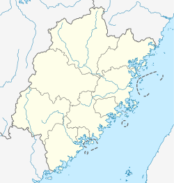 Pingtan Location of the seat in Fujian | |
| Coordinates (Pingtan government): 25°29′55″N 119°47′25″E / 25.49861°N 119.79028°E | |
| Country | People's Republic of China |
| Province | Fujian |
| Prefecture-level city | Fuzhou |
| Seat[1] | Tancheng |
| Area | |
| • Total | 6,435 km2 (2,485 sq mi) |
| • Land | 371.91 km2 (143.60 sq mi) |
| • Water | 6,064 km2 (2,341 sq mi) 94.2% |
| Elevation | 44 m (143 ft) |
| Population (2009) | |
| • Total | 400,000 |
| • Density | 1,078/km2 (2,790/sq mi) |
| Time zone | UTC+8 (China Standard) |
| Area code | 0591 |
| Website | english |
| Pingtan County | |||||||||||
|---|---|---|---|---|---|---|---|---|---|---|---|
| Traditional Chinese | 平潭縣 | ||||||||||
| Simplified Chinese | 平潭县 | ||||||||||
| |||||||||||
History edit
During the Qing Dynasty, Pingtan Ting (平潭廳) was created. In 1913, Pingtan County was established.[1]
On September 27–28, 2016, Typhoon Megi brought torrential rains across Pingtan. Bus lines resumed normal operations on September 29.[3]
Geography edit


Pingtan County has a total land area of 371 square kilometres (143 sq mi), comprising 126[2] islands, and covers 6,064 square kilometres (2,341 sq mi) of sea. The main island, Haitan Island, covers an area of 267 square kilometres (103 sq mi),[4] or 72% of the county's land area, and is the largest island in all of Fujian. Niushan Island is located in the eastern part of the county. To the east is the Taiwan Strait. The area is the closest place in mainland China (PRC) to the main island of Taiwan.[2][5]
Climate edit
Pingtan, by virtue of its maritime location, has a moderated climate, with high humidity and minimal diurnal temperature variation. Under the Köppen climate classification, it has a humid subtropical climate (Cfa), with mild winters and hot, humid summers, though much cooler than inland places. The monthly daily average temperature ranges from 11.5 °C (52.7 °F) in February to 28.1 °C (82.6 °F) in July. The bulk of the rainfall annually occurs in spring and early summer, while autumn and early winter is the driest time of the year. The area experiences windy weather, with an average wind speed of 17.3 kilometres per hour (10.7 mph), and wind directions are consistent. Freezing temperatures have never been recorded here.[4]
| Climate data for Pingtan (1991–2020 normals, extremes 1971–2010) | |||||||||||||
|---|---|---|---|---|---|---|---|---|---|---|---|---|---|
| Month | Jan | Feb | Mar | Apr | May | Jun | Jul | Aug | Sep | Oct | Nov | Dec | Year |
| Record high °C (°F) | 26.4 (79.5) |
27.9 (82.2) |
28.6 (83.5) |
30.3 (86.5) |
31.7 (89.1) |
34.4 (93.9) |
35.6 (96.1) |
35.3 (95.5) |
34.5 (94.1) |
32.7 (90.9) |
29.3 (84.7) |
26.7 (80.1) |
35.6 (96.1) |
| Mean daily maximum °C (°F) | 13.9 (57.0) |
14.3 (57.7) |
16.8 (62.2) |
21.2 (70.2) |
25.1 (77.2) |
28.6 (83.5) |
31.1 (88.0) |
31.0 (87.8) |
29.0 (84.2) |
24.8 (76.6) |
20.9 (69.6) |
16.4 (61.5) |
22.8 (73.0) |
| Daily mean °C (°F) | 11.7 (53.1) |
11.6 (52.9) |
13.8 (56.8) |
18.1 (64.6) |
22.4 (72.3) |
26.1 (79.0) |
28.4 (83.1) |
28.4 (83.1) |
26.8 (80.2) |
23.1 (73.6) |
19.1 (66.4) |
14.3 (57.7) |
20.3 (68.6) |
| Mean daily minimum °C (°F) | 10.1 (50.2) |
9.8 (49.6) |
11.6 (52.9) |
15.8 (60.4) |
20.5 (68.9) |
24.3 (75.7) |
26.5 (79.7) |
26.5 (79.7) |
25.1 (77.2) |
21.7 (71.1) |
17.6 (63.7) |
12.8 (55.0) |
18.5 (65.3) |
| Record low °C (°F) | 0.9 (33.6) |
2.2 (36.0) |
3.2 (37.8) |
5.4 (41.7) |
11.2 (52.2) |
16.1 (61.0) |
20.5 (68.9) |
21.7 (71.1) |
16.8 (62.2) |
13.5 (56.3) |
8.5 (47.3) |
3.0 (37.4) |
0.9 (33.6) |
| Average precipitation mm (inches) | 51.3 (2.02) |
71.3 (2.81) |
105.5 (4.15) |
110.0 (4.33) |
162.5 (6.40) |
238.3 (9.38) |
136.5 (5.37) |
144.6 (5.69) |
120.9 (4.76) |
36.7 (1.44) |
52.1 (2.05) |
45.3 (1.78) |
1,275 (50.18) |
| Average precipitation days (≥ 0.1 mm) | 8.6 | 11.1 | 14.7 | 13.4 | 13.7 | 12.6 | 6.2 | 8.3 | 9.4 | 6.0 | 7.8 | 8.3 | 120.1 |
| Average snowy days | 0.1 | 0 | 0 | 0 | 0 | 0 | 0 | 0 | 0 | 0 | 0 | 0 | 0.1 |
| Average relative humidity (%) | 77 | 79 | 81 | 82 | 85 | 86 | 82 | 82 | 78 | 75 | 77 | 75 | 80 |
| Mean monthly sunshine hours | 86.9 | 83.3 | 99.6 | 112.6 | 119.0 | 148.7 | 247.8 | 225.4 | 180.7 | 144.4 | 88.7 | 90.5 | 1,627.6 |
| Percent possible sunshine | 26 | 26 | 27 | 29 | 29 | 36 | 59 | 56 | 49 | 41 | 27 | 28 | 36 |
| Source: China Meteorological Administration[6][7][4] | |||||||||||||
Administrative divisions edit
The county executive, legislature and judiciary is in Tancheng Town, colloquially called Pingtan, together with the CPC and PSB branches. The county administers 7 towns and 8 townships, accounting for 200 neighbourhood and village committees.[8][9]
Towns edit
- Tancheng (潭城镇) Tàng-siàng Déng
- Su'ao (Su-ao; 苏澳镇) Sŭ-ó̤ Déng 25°36′58″N 119°42′24″E / 25.616017°N 119.706692°E
- Liushui (Liu-shui; 流水镇) Làu-cuōi Déng
- Aoqian (澳前镇) Ó̤-sèng Déng 25°28′43″N 119°49′36″E / 25.478664°N 119.826739°E
- Beicuo (北厝镇) Báe̤k-chió Déng
- Pingyuan (平原镇) Bìng-nguòng Déng
- Aodong (敖东镇) Ngò̤-dĕ̤ng Déng
Townships edit
- Baiqing (白青乡) Băh-chăng Hiŏng
- Yutou (屿头乡) Sê̤ṳ-tàu Hiŏng
- Dalian (大练乡) Duâi-liêng Hiŏng
- Luyang (芦洋乡) Lù-iòng Hiŏng
- Zhonglou (中楼乡) Dṳ̆ng-làu Hiŏng
- Dongxiang (东庠乡) Dĕ̤ng-siòng Hiŏng 25°35′40″N 119°52′55″E / 25.594566°N 119.881818°E
- Lancheng (岚城乡) Làng-siàng Hiŏng 25°30′39″N 119°46′39″E / 25.510698°N 119.777524°E
- Nanhai (南海乡) Nàng-hāi Hiŏng
Economy edit
Agricultural products include sweet potatoes and peanuts among others. To the east of the county is the Niushan fishery which produces yellow fish (黄鱼) and cutlassfish in abundance among others. Tangyu zicai (塘屿紫菜) is a local speciality. Mineral resources include coal, iron, and quartz. Industries include mining, salt making, fishery processing, seafood processing, machinery, and shipbuilding. Handicrafts include scrimshaw.[1]
References edit
- ^ a b c d 夏征农; 陈至立, eds. (September 2009). 辞海:第六版彩图本 [Cihai (Sixth Edition in Color)] (in Chinese). Shanghai: Shanghai Lexicographical Publishing House. p. 1744. ISBN 9787532628599.
- ^ a b c "About Pingtan". Pingtan, China. Retrieved 29 March 2020.
Pingtan is made up of 126 islands with Haitan the largest island.{...}It is also the closest island county on the mainland to Taiwan.{...}With a coastline of 399.82 kilometers, the county bears a land area of 371.91 square kilometers and a sea area of more than 6,000 square kilometers.
- ^ "Pingtan experiences typhoon Megi". China Daily. 30 September 2016. Retrieved 30 March 2020.
- ^ a b c 平潭 - 气象数据-中国天气网 (in Simplified Chinese). Weather China. Retrieved 2011-12-21.
- ^ "FEATURE: China woos Taiwan with offshore 'common homeland'". Taipei Times. 9 February 2014. Archived from the original on 7 June 2015. Retrieved 27 March 2020 – via WebCite.
Pingtan island is physically China's closest spot to Taiwan
- ^ 中国气象数据网 – WeatherBk Data (in Simplified Chinese). China Meteorological Administration. Retrieved 23 June 2023.
- ^ 中国气象数据网 (in Simplified Chinese). China Meteorological Administration. Retrieved 23 June 2023.
- ^ 平潭县历史沿革 [Pingtan County Historical Evolution]. XZQH.org (in Simplified Chinese). 16 June 2015. Retrieved 27 March 2020.
1996年,平潭县陆地面积321.4平方千米,{...}2000年,撤销平原乡,设立平原镇;撤销敖东乡,设立敖东镇。2000年第五次人口普查,平潭县常住总人口371922人,。{...}2010年第六次人口普查,平潭县常住总人口357760人,其中:潭城镇111447人,苏澳镇17834人,流水镇41001人,澳前镇42856人,北厝镇21915人,平原镇15041人,敖东镇20453人,白青乡12271人,屿头乡13852人,大练乡4505人,芦洋乡3786人,中楼乡16333人,东庠乡6391人,岚城乡23741人,南海乡6334人。
- ^ 2019年统计用区划代码和城乡划分代码:平潭县 [2019 Statistical Area Numbers and Rural-Urban Area Numbers: Pingtan County] (in Simplified Chinese). National Bureau of Statistics of the People's Republic of China. 2019. Retrieved 27 March 2020.
统计用区划代码 名称 350128100000 潭城镇 350128101000 苏澳镇 350128102000 流水镇 350128103000 澳前镇 350128104000 北厝镇 350128105000 平原镇 350128106000 敖东镇 350128200000 白青乡 350128201000 屿头乡 350128202000 大练乡 350128203000 芦洋乡 350128204000 中楼乡 350128205000 东庠乡 350128206000 岚城乡 350128207000 南海乡
External links edit
- Pingtan,China Pingtan Government official website (in English)
- 【大陸尋奇#1829】福建平潭 海上絲路 20190825 ('Dalu Xunqi #1829: Fujian Pingtan, an Oceanic Silk Road- August 25, 2019') (in Chinese)
- 平潭综合实验区管委会办公室关于印发平潭综合实验区(平潭县)乡镇行政区划调整突发事件应急处置预案的通知 (in Chinese)