


Summary
Pinnaroo is a town in the Murray Mallee region of South Australia, near the border with Victoria, 243 km east of Adelaide. Pinnaroo is on the north side of the Mallee Highway, and on the railway line between Tailem Bend and Ouyen. The roadhouse on the highway at Pinnaroo is the first "food and leg-stretch" stop on the bus route from Adelaide to Sydney.
| Pinnaroo South Australia | |||||||||||||||
|---|---|---|---|---|---|---|---|---|---|---|---|---|---|---|---|
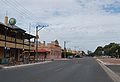
 Pinnaroo main street, looking east | |||||||||||||||
 Pinnaroo | |||||||||||||||
| Coordinates | 35°15′39″S 140°54′21″E / 35.26086°S 140.905913°E[1] | ||||||||||||||
| Population | 575 (UCL 2021)[2] | ||||||||||||||
| Established | 17 November 1904 (town) 2 August 1999 (locality)[3][4] | ||||||||||||||
| Postcode(s) | 5304 | ||||||||||||||
| Location | 243 km (151 mi) east of Adelaide | ||||||||||||||
| LGA(s) | Southern Mallee District Council[1] | ||||||||||||||
| Region | Murray and Mallee[1] | ||||||||||||||
| County | Chandos[1] | ||||||||||||||
| State electorate(s) | Hammond[5] | ||||||||||||||
| Federal division(s) | Barker[6] | ||||||||||||||
| |||||||||||||||
| |||||||||||||||
| Footnotes | Adjoining localities[1][8] | ||||||||||||||
History edit
The town's name is derived from a word for "big man" in a local Aboriginal language.[9] The railway arrived in the area in 1906.[10] There had not been any significant development in the area before that, as the remoteness and difficulty of getting supplies in and produce out had made it uneconomic to farm before that.
Economy edit
The railway is not currently available for transport between the states, as the line from Tailem Bend was converted to standard gauge and more recently mothballed forcing grain to be trucked to the port. The town has become a major centre for growing potatoes since around 1990.[11]
Recreation edit
Pinnaroo has a show and field days every year at the start of October. The Pinnaroo Show features dog trials, agricultural tents, competitions, horse events, keg tosses, animal judging and fireworks. The show attracts large numbers people each year.
The Peebinga Conservation Park is 42 kilometres (26 mi) north of Pinnaroo, Karte Conservation Park 30 km north-west, and the much larger Ngarkat Conservation Park is 28 kilometres (17 mi) south of the town.[10] All of which provide off road access.
The town has a large variety of sports, such as Australian rules football, netball, cricket, tennis, basketball, volleyball, lawn bowls, badminton, golf and darts. The local football team, the Pinnaroo Supa Roos play in the Mallee Football League.
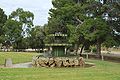
From about 2012 to 2020, residents of Pinnaroo volunteered their time and effort to transform a stormwater collection site, formerly an old railway dam for steam trains, into a wetland bordering the Mallee Highway. It is the only water attraction in the area, and a popular place to explore nature or sit and watch the birdlife, which includes crakes and grebes.[12]
Government edit
Pinnaroo is the seat of the local government area of the Southern Mallee District Council, and is in the state electoral district of Chaffey and the federal division of Barker.[6][5][1]
Media edit
The Border Times is a weekly newspaper published since 1911.
Education edit
Pinnaroo Primary School is a public primary school for students in Reception to Year 7, and has approximately 80 students. The school has four composite classes - Reception, Years 1 and 2, Years 3 and 4, and Years 5,6 and 7. It is the only school within 30 km of the town. The school's slogan is Aim High. The school is home to South Australia's first community library, which opened in 1977.[13]
The school regularly takes part in interschool sports with neighbouring schools, Lameroo and Geranium, in swimming and athletics. The school also takes part in SAPSASA with the Murray Mallee team in sports such as Australian rules football, cricket, athletics, swimming, golf, softball, tennis, netball and basketball. The school has four classrooms, a GP room, an art and technical centre, a home economics centre, an FM radio station, a swimming pool, two ovals, outdoor tennis, netball and basketball courts, and a full-size gymnasium.
Tourism edit
Pinnaroo is home to the Mallee Tourist and Heritage Centre, which apart from displays on local farming history, has well-maintained and presented collections relative to three distinct topics: history of wheat breeding (featuring the D. A. Wurfel grain collection); an extensive range of restored farm machinery, based on the Gum Family Collection, which includes a replica Ridley stripper; and letterpress printing. The museum, which is supported by the Pinnaroo Historical Society, is situated opposite the large and popular bakery.
Gallery edit
-
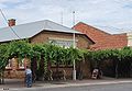
 Main Street
 -
 Main Street
 -
 Main Street
 -
 Post Office
 -

-
-
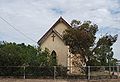
 Lutheran Church
 -
 Fountain
 -
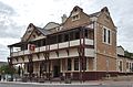 Golden Grain Hotel
 -
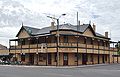 Pinnaroo Hotel
 -
 Pinnaroo Institute
 -
 Memorial Clock
 -
 Memorial Hospital
 -
 War Memorial


External links edit
- Mallee Tourist and Heritage Centre
- Pinnaroo Historical Society
References edit
- ^ a b c d e f "Search results for 'Lameroo, LOCB' with the following datasets being selected - 'Suburbs and Localities', 'Government Towns', 'Counties', 'Local Government Areas', 'SA Government Regions' and 'Gazetteer'". Location SA Map Viewer. Government of South Australia. Retrieved 5 May 2018.
- ^ Australian Bureau of Statistics (28 June 2022). "Pinnaroo (urban centre and locality)". Australian Census 2021.
- ^ Jenkins, J.G. (17 November 1904). "TOWNS OF PINNAROO AND LAMEROO" (PDF). The South Australian Government Gazette. Government of South Australia: 919–920. Retrieved 5 May 2018.
- ^ Lawson, Robert (12 August 1999). "GEOGRAPHICAL NAMES ACT 1991 Notice to Assign Boundaries to Places (in the Southern Mallee District Council)" (PDF). The South Australian Government Gazette. South Australian Government. p. 766. Retrieved 4 May 2018.
- ^ a b "District of Hammond (map)". Electoral Commission SA. Retrieved 4 May 2018.
- ^ a b "Federal electoral division of Barker, boundary gazetted 16 December 2011" (PDF). Australian Electoral Commission. Retrieved 17 September 2015.
- ^ a b c "Summary (climate) statistics LAMEROO (nearest weather station)". Commonwealth of Australia, Bureau of Meteorology. Retrieved 3 May 2018.
- ^ "Mildura Rural City, Suburb and Rural District names and boundaries (map)" (PDF). The State of Victoria, Department of Sustainability and Environment. 2011. Retrieved 5 May 2018.
- ^ "Hundred of Pinnaroo". PlaceNames Online. Land Services SA. 16 June 2003. Archived from the original on 30 September 2007. Retrieved 7 July 2007.
- ^ a b "Pinnaroo". Walkabout. Fairfax Media. Archived from the original on 29 October 2005. Retrieved 7 July 2007.
- ^ Graham Badger; Ian Henschke (2 April 2004). "The Humble Potato is Saving One of South Australia's Country Towns". Stateline (South Australian edition). Australian Broadcasting Company. Retrieved 7 July 2007.
- ^ Heuzenroeder, Catherine (15 June 2020). "Farming town pulls off epic backyard blitz to bring stormwater eyesore to life as tranquil wetland". Australia: ABC News. Retrieved 16 June 2020.
- ^ "Pinnaroo Community Library". Southern Mallee District Council. Retrieved 20 January 2008.