


Summary
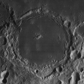
Pitatus is an ancient lunar impact crater located at the southern edge of Mare Nubium. It was named after Italian astronomer Pietro Pitati by the IAU in 1935.[1] Joined to the northwest rim is the crater Hesiodus, and the two are joined by a narrow cleft. To the south lie the attached Wurzelbauer and Gauricus.
 Lunar Orbiter 4 image | |
| Coordinates | 29°53′S 13°32′W / 29.88°S 13.53°W |
|---|---|
| Diameter | 100.63 km[1] |
| Depth | 0.9 km |
| Colongitude | 13° at sunrise |
| Eponym | Pietro Pitati |
Description edit
The complex wall of Pitatus is heavily worn, and has been encroached by lava flows. The rim is lowest to the north, where the lava almost joins the Mare Nubium. Near the middle is a low central peak that is offset to the northwest of center. This peak only rises to a height of 0.5 km.
Pitatus is a floor-fractured crater, meaning it was flooded from the interior by magma intrusion through cracks and openings. (See also Gassendi and Posidonius for similar features.) The flooded crater floor contains low hills in the east and a system of slender clefts named the Rimae Pitatus. The larger and more spectacular of these rilles follow the edges of the inner walls, especially in the northern and eastern halves. The floor also contains the faint traces of deposited ray markings.
Just to the north of Pitatus in the neighboring mare is the half-buried rim of Pitatus S, covered in the past when Mare Nubium was formed.
Satellite craters edit

By convention these features are identified on lunar maps by placing the letter on the side of the crater midpoint that is closest to Pitatus.

| Pitatus | Latitude | Longitude | Diameter |
|---|---|---|---|
| A | 31.4° S | 13.2° W | 7 km |
| B | 32.3° S | 10.4° W | 16 km |
| C | 28.4° S | 12.4° W | 12 km |
| D | 30.9° S | 12.0° W | 10 km |
| E | 28.9° S | 10.1° W | 6 km |
| G | 29.8° S | 11.4° W | 18 km |
| H | 30.5° S | 15.7° W | 15 km |
| J | 26.5° S | 13.5° W | 5 km |
| K | 30.4° S | 8.9° W | 6 km |
| L | 29.1° S | 8.6° W | 5 km |
| M | 32.1° S | 11.0° W | 14 km |
| N | 31.2° S | 10.9° W | 21 km |
| P | 31.0° S | 10.9° W | 16 km |
| Q | 30.5° S | 10.8° W | 12 km |
| R | 31.1° S | 14.6° W | 7 km |
| S | 27.3° S | 14.0° W | 12 km |
| T | 29.4° S | 11.2° W | 5 km |
| V | 28.9° S | 11.7° W | 5 km |
| W | 27.9° S | 11.2° W | 13 km |
| X | 28.4° S | 11.6° W | 19 km |
| Z | 28.3° S | 10.3° W | 25 km |
References edit
- ^ a b "Pitatus (crater)". Gazetteer of Planetary Nomenclature. USGS Astrogeology Research Program.
- ^ The geologic history of the Moon. USGS Professional Paper 1348. By Don E. Wilhelms, John F. McCauley, and Newell J. Trask. U.S. Government Printing Office, Washington: 1987. Table 9-4.
- Andersson, L. E.; Whitaker, E. A. (1982). NASA Catalogue of Lunar Nomenclature. NASA RP-1097.
- Bussey, B.; Spudis, P. (2004). The Clementine Atlas of the Moon. New York: Cambridge University Press. ISBN 978-0-521-81528-4.
- Cocks, Elijah E.; Cocks, Josiah C. (1995). Who's Who on the Moon: A Biographical Dictionary of Lunar Nomenclature. Tudor Publishers. ISBN 978-0-936389-27-1.
- McDowell, Jonathan (July 15, 2007). "Lunar Nomenclature". Jonathan's Space Report. Retrieved 2007-10-24.
- Menzel, D. H.; Minnaert, M.; Levin, B.; Dollfus, A.; Bell, B. (1971). "Report on Lunar Nomenclature by the Working Group of Commission 17 of the IAU". Space Science Reviews. 12 (2): 136–186. Bibcode:1971SSRv...12..136M. doi:10.1007/BF00171763. S2CID 122125855.
- Moore, Patrick (2001). On the Moon. Sterling Publishing Co. ISBN 978-0-304-35469-6.
- Price, Fred W. (1988). The Moon Observer's Handbook. Cambridge University Press. ISBN 978-0-521-33500-3.
- Rükl, Antonín (1990). Atlas of the Moon. Kalmbach Books. ISBN 978-0-913135-17-4.
- Webb, Rev. T. W. (1962). Celestial Objects for Common Telescopes (6th revised ed.). Dover. ISBN 978-0-486-20917-3.
- Whitaker, Ewen A. (1999). Mapping and Naming the Moon. Cambridge University Press. ISBN 978-0-521-62248-6.
- Wlasuk, Peter T. (2000). Observing the Moon. Springer. ISBN 978-1-85233-193-1.