


Summary
Plaistow (/ˈplɑːstoʊ/ PLAHST-oh, /ˈplæstoʊ/ PLAST-oh, or /ˈpleɪstoʊ/ PLAYST-oh)[2][3][4] is an area of south-east London located in the London Borough of Bromley and, until 1965, in the historic county of Kent. It is located south of Downham and Grove Park and north of Sundridge Park and Bromley. Nowadays Plaistow overlaps somewhat with Sundridge, for example the main Sundridge Park shopping parade by the station sits directly east of Plaistow Green, with business and facilities in the area using the two names interchangeably. Plaistow now refers especially to the area north of Sundridge Park station along Burnt Ash Lane, part of the A2212 road which runs north to south between Grove Park and Bromley.
| Plaistow, Bromley | |
|---|---|
 Plaistow, Bromley Location within Greater London | |
| Population | 15,122 (2011 Census. Plaistow and Sundridge Ward)[1] |
| London borough | |
| Ceremonial county | Greater London |
| Region | |
| Country | England |
| Sovereign state | United Kingdom |
| Postcode district | BR1 |
| Police | Metropolitan |
| Fire | London |
| Ambulance | London |
| London Assembly | |
History edit

The area is first mentioned in 1278, and is thought to refer to games that were played here.[6] Much of the area was purchased by the banker Peter Thellusson in 1777, and he built Plaistow Lodge here as his home (now converted into Parish Church of England Primary School and listed at grade II*).[6][7] An iron church was later built besides the lodge in 1875.[6] Housing development by the People's Freehold Land Society began after the arrival of the railway in 1878 (later rebuilt in 1896).[6] St Mary's Church was consecrated in 1863 and enlarged three times between 1881 and 1900.[citation needed] The churchyard closed for burials in 1893 when Plaistow Cemetery opened.[8][6] In 1926 a wall was built along Valeswood Road after complaints by local residents that 'vulgar' working class persons from the Downham estate were cutting through the area on their way to Bromley town centre.[6] The wall remained in place for roughly 10 years.[6][9]
Gallery edit
-
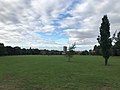
 Plaistow Green
 -
 The Prince Frederick pub, Nichol Lane
 -
 King's Meadow
 -
![St Andrew's Church, Burnt Ash Lane, built in 1929 by Sir Charles Nicholson[10]](//upload.wikimedia.org/wikipedia/commons/thumb/b/b3/St_Andrew%27s_church%2C_Plaistow.jpg/120px-St_Andrew%27s_church%2C_Plaistow.jpg) St Andrew's Church, Burnt Ash Lane, built in 1929 by Sir Charles Nicholson[10]
St Andrew's Church, Burnt Ash Lane, built in 1929 by Sir Charles Nicholson[10] -
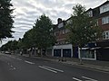 Shops along Burnt Ash Lane


![St Andrew's Church, Burnt Ash Lane, built in 1929 by Sir Charles Nicholson[10]](http://upload.wikimedia.org/wikipedia/commons/thumb/b/b3/St_Andrew%27s_church%2C_Plaistow.jpg/120px-St_Andrew%27s_church%2C_Plaistow.jpg)

References edit
- ^ "Bromley Ward population 2011". Neighbourhood Statistics. Office for National Statistics. Retrieved 11 October 2016.
- ^ Wells, J. C. (2008). Longman Pronunciation Dictionary, 3rd edn, Harlow, UK: Longman
- ^ Daniel Jones, Peter Roach, et al. (2011). Cambridge Pronouncing Dictionary, 18th edn, Cambridge, UK: Cambridge University Press
- ^ Martha Figueroa-Clark,"BBC - Magazine Monitor: How to Say: Plaistow", BBC, 16 October 2009. Retrieved 2015-11-21.
- ^ "Plaistow Cemetery". Parks & Gardens. Retrieved 31 August 2020.
- ^ a b c d e f g Willey, Russ (2006). The London Gazzetteer. Chambers Harrap Publishers Ltd. pp. 388–9.
- ^ Historic England. "QUERNMORE SECONDARY SCHOOL (1055761)". National Heritage List for England. Retrieved 30 August 2020.
- ^ "London Gardens Online, St Mary's Churchyard, Plaistow". London Parks and Gardens Trust. Retrieved 18 February 2013.
- ^ Nelson, Michael. "Gated Communities: Class Walls". History Today. Retrieved 30 August 2020.
- ^ "St Andrew, Burnt Ash Lane, Bromley". London Church Buildings. 5 March 2017. Retrieved 31 August 2020.