
KNOWPIA
WELCOME TO KNOWPIA

Plouguin 
Summary
Plouguin (French pronunciation: [pluɡɛ̃]; Breton: Plougin) is a commune in the Finistère department of Brittany in north-western France.
Plouguin
Plougin | |
|---|---|
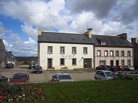 The town hall in Plouguin | |
 Coat of arms | |
Location of Plouguin .mw-parser-output .locmap .od{position:absolute}.mw-parser-output .locmap .id{position:absolute;line-height:0}.mw-parser-output .locmap .l0{font-size:0;position:absolute}.mw-parser-output .locmap .pv{line-height:110%;position:absolute;text-align:center}.mw-parser-output .locmap .pl{line-height:110%;position:absolute;top:-0.75em;text-align:right}.mw-parser-output .locmap .pr{line-height:110%;position:absolute;top:-0.75em;text-align:left}.mw-parser-output .locmap .pv>div{display:inline;padding:1px}.mw-parser-output .locmap .pl>div{display:inline;padding:1px;float:right}.mw-parser-output .locmap .pr>div{display:inline;padding:1px;float:left}html.skin-theme-clientpref-night .mw-parser-output .od,html.skin-theme-clientpref-night .mw-parser-output .od .pv>div,html.skin-theme-clientpref-night .mw-parser-output .od .pl>div,html.skin-theme-clientpref-night .mw-parser-output .od .pr>div{background:#000;color:#fff}html.skin-theme-clientpref-night .mw-parser-output .locmap{filter:grayscale(0.6)}@media(prefers-color-scheme:dark){html.skin-theme-clientpref-os .mw-parser-output .locmap{filter:grayscale(0.6)}html.skin-theme-clientpref-os .mw-parser-output .od,html.skin-theme-clientpref-os .mw-parser-output .od .pv>div,html.skin-theme-clientpref-os .mw-parser-output .od .pl>div,html.skin-theme-clientpref-os .mw-parser-output .od .pr>div{background:#000;color:#fff}}  Plouguin  Plouguin | |
| Coordinates: 48°31′31″N 4°36′00″W / 48.5253°N 4.6000°W | |
| Country | France |
| Region | Brittany |
| Department | Finistère |
| Arrondissement | Brest |
| Canton | Plabennec |
| Government | |
| • Mayor (2020–2026) | Roger Talarmain[1] |
| Area 1 | 31.02 km2 (11.98 sq mi) |
| Population (2021)[2] | 2,204 |
| • Density | 71/km2 (180/sq mi) |
| Time zone | UTC+01:00 (CET) |
| • Summer (DST) | UTC+02:00 (CEST) |
| INSEE/Postal code | 29196 /29830 |
| Elevation | 0–82 m (0–269 ft) |
| 1 French Land Register data, which excludes lakes, ponds, glaciers > 1 km2 (0.386 sq mi or 247 acres) and river estuaries. | |
It lies 20 km (12 mi) northwest of Brest, about 7 km (4.3 mi) from the English Channel in the far west of the Leon peninsula.
Population edit
Inhabitants of Plouguin are called in French Plouguinois.
| Year | Pop. | ±% p.a. |
|---|---|---|
| 1968 | 1,418 | — |
| 1975 | 1,373 | −0.46% |
| 1982 | 1,920 | +4.91% |
| 1990 | 2,060 | +0.88% |
| 1999 | 1,955 | −0.58% |
| 2007 | 2,050 | +0.59% |
| 2012 | 2,121 | +0.68% |
| 2017 | 2,151 | +0.28% |
| Source: INSEE[3] | ||
Saint Winwaloe edit
Plouguin is considered to have been (about 460) the birthplace of Saint Winwaloe, and his supposed place of birth, a feudal hillock, is still pointed out.
International relations edit
Plouguin is twinned with the town of Newport in Pembrokeshire, Wales.
See also edit
References edit
- ^ "Répertoire national des élus: les maires". data.gouv.fr, Plateforme ouverte des données publiques françaises (in French). 2 December 2020.
- ^ "Populations légales 2021". The National Institute of Statistics and Economic Studies. 28 December 2023.
- ^ Population en historique depuis 1968, INSEE
External links edit
Wikimedia Commons has media related to Plouguin.
- Official website (in French)
- Base Mérimée: Search for heritage in the commune, Ministère français de la Culture. (in French)
- Mayors of Finistère Association (in French)