
KNOWPIA
WELCOME TO KNOWPIA

Plumergat 
Summary
Plumergat (Breton: Pluvergad) is a commune in the Morbihan department of Brittany in north-western France.[3]
Plumergat
Pluvergad | |
|---|---|
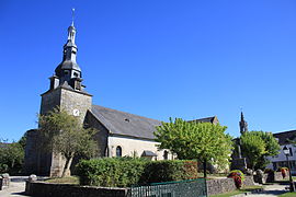 The church of Saint-Thuriau, in Plumergat | |
 Coat of arms | |
Location of Plumergat .mw-parser-output .locmap .od{position:absolute}.mw-parser-output .locmap .id{position:absolute;line-height:0}.mw-parser-output .locmap .l0{font-size:0;position:absolute}.mw-parser-output .locmap .pv{line-height:110%;position:absolute;text-align:center}.mw-parser-output .locmap .pl{line-height:110%;position:absolute;top:-0.75em;text-align:right}.mw-parser-output .locmap .pr{line-height:110%;position:absolute;top:-0.75em;text-align:left}.mw-parser-output .locmap .pv>div{display:inline;padding:1px}.mw-parser-output .locmap .pl>div{display:inline;padding:1px;float:right}.mw-parser-output .locmap .pr>div{display:inline;padding:1px;float:left}html.skin-theme-clientpref-night .mw-parser-output .od,html.skin-theme-clientpref-night .mw-parser-output .od .pv>div,html.skin-theme-clientpref-night .mw-parser-output .od .pl>div,html.skin-theme-clientpref-night .mw-parser-output .od .pr>div{background:#000;color:#fff}html.skin-theme-clientpref-night .mw-parser-output .locmap{filter:grayscale(0.6)}@media(prefers-color-scheme:dark){html.skin-theme-clientpref-os .mw-parser-output .locmap{filter:grayscale(0.6)}html.skin-theme-clientpref-os .mw-parser-output .od,html.skin-theme-clientpref-os .mw-parser-output .od .pv>div,html.skin-theme-clientpref-os .mw-parser-output .od .pl>div,html.skin-theme-clientpref-os .mw-parser-output .od .pr>div{background:#000;color:#fff}}  Plumergat  Plumergat | |
| Coordinates: 47°44′32″N 2°55′00″W / 47.7422°N 2.9167°W | |
| Country | France |
| Region | Brittany |
| Department | Morbihan |
| Arrondissement | Lorient |
| Canton | Auray |
| Intercommunality | Auray Quiberon Terre Atlantique |
| Government | |
| • Mayor (2020–2026) | Sandrine Cadoret[1] |
| Area 1 | 41.94 km2 (16.19 sq mi) |
| Population (2021)[2] | 4,179 |
| • Density | 100/km2 (260/sq mi) |
| Time zone | UTC+01:00 (CET) |
| • Summer (DST) | UTC+02:00 (CEST) |
| INSEE/Postal code | 56175 /56400 |
| Elevation | 17–88 m (56–289 ft) |
| 1 French Land Register data, which excludes lakes, ponds, glaciers > 1 km2 (0.386 sq mi or 247 acres) and river estuaries. | |
Geography edit
Plumergat is located 10 km (6.2 mi) northeast of Auray, 15 km (9.3 mi) northwest of Vannes and 34 km (21 mi) east of Lorient. Plumergat is border by Sainte-Anne-d'Auray and Pluneret to the south. The village of Meriadec, which has 700 inhabitants, is divided in two between Pluneret and Plumergat.

Population edit
| Year | Pop. | ±% p.a. |
|---|---|---|
| 1968 | 1,773 | — |
| 1975 | 1,961 | +1.45% |
| 1982 | 2,291 | +2.25% |
| 1990 | 2,449 | +0.84% |
| 1999 | 2,597 | +0.65% |
| 2007 | 3,232 | +2.77% |
| 2012 | 3,774 | +3.15% |
| 2017 | 4,112 | +1.73% |
| Source: INSEE[4] | ||
Inhabitants of Plumergat are called in French Plumergatais.
Breton language edit
In 2011, 6.6% of the children attended the bilingual schools in primary education.[5]
See also edit
References edit
- ^ "Maires du Morbihan" (PDF). Préfecture du Morbihan. 7 July 2020.
- ^ "Populations légales 2021". The National Institute of Statistics and Economic Studies. 28 December 2023.
- ^ INSEE commune file
- ^ Population en historique depuis 1968, INSEE
- ^ (in French) Ofis ar Brezhoneg: Situation de l’enseignement bilingue en 2011
External links edit
Wikimedia Commons has media related to Plumergat.
- Base Mérimée: Search for heritage in the commune, Ministère français de la Culture. (in French)
- Mayors of Morbihan Association (in French)