Poinsett Bridge

Summary

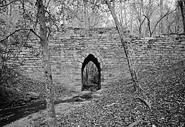
Poinsett Bridge is the oldest bridge in South Carolina and perhaps in the entire southeastern United States.[2][3] Named for Joel Roberts Poinsett, it was built in 1820 as part of a road from Columbia, South Carolina, to Saluda Mountain.[4][5] The stone bridge, which includes a 14-foot (4.3 m) Gothic arch and stretches 130 feet (40 m) over Little Gap Creek, may have been designed by Robert Mills, architect of the Washington Monument.[6] Though no longer in use, the bridge remains largely intact[7][8] and is part of the 120-acre (48.6 ha) Poinsett Bridge Heritage Preserve. There is a nature trail a few hundred yards from the bridge.[3][9] The bridge, about which ghost stories have been told for decades,[10] is located off U.S. Highway 25 north of Greenville, South Carolina.[11] The bridge was added to the National Register of Historic Places in 1970.[1]

Poinsett Bridge
Poinsett Bridge
Coordinates35°07′44″N 82°23′02″W / 35.129°N 82.384°W / 35.129; -82.384
CrossesLittle Gap Creek
LocaleGreenville County, South Carolina
Characteristics
Total length130 feet (40 m)
Clearance above15 feet (5 m)
Statistics
Toll
Poinsett Bridge
Poinsett Bridge is located in South Carolina
Poinsett Bridge
Poinsett Bridge is located in the United States
Poinsett Bridge
Nearest cityTigerville, South Carolina
Coordinates35°07′46.1″N 82°23′03.4″W / 35.129472°N 82.384278°W / 35.129472; -82.384278
Area6 acres (2.4 ha)
Built1820
NRHP reference No.70000590[1]
Added to NRHPOctober 22, 1970
Location
Poinsett Bridge from afar

See also edit

References edit

  1. ^ a b "National Register Information System". National Register of Historic Places. National Park Service. July 9, 2010.
  2. ^ Hawkins, Celeste. "The Real Story of South Carolina's Oldest, Most Memorable Bridge". Travelers Rest Here.
  3. ^ a b Sowell, Charles (March 6, 2015). "Poinsett Bridge is always worth the trip". Greenville News. p. 23.
  4. ^ Schuette, Mary (August 29, 1970). "Poinsett Bridge" (PDF). National Register of Historic Places - Nomination and Inventory. Retrieved 7 July 2012.
  5. ^ "Poinsett Bridge, Greenville County (S.C. Sec. Rd. 42, Tigerville vicinity)". National Register Properties in South Carolina. South Carolina Department of Archives and History. Retrieved 7 July 2012.
  6. ^ "Poinsett Bridge". Greenville County Recreation District. The Tulane University library has a brush drawing by Mills of a similar bridge, lending credence to the belief that Mills designed it.
  7. ^ Edgar, Walter, ed. (2006). The South Carolina Encyclopedia. University of South Carolina Press. pp. 739–740. ISBN 1-57003-598-9.
  8. ^ "The Adventure Files: Poinsett Bridge". The Greene Affect. Retrieved 2022-01-17.
  9. ^ "Poinsett Bridge Heritage Preserve". South Carolina Department of Natural Resources. Archived from the original on 2007-03-14.
  10. ^ "The History and Haunting of Poinsett Bridge," Library Now (Greenville County Library System), Fall 2021, 8-10.
  11. ^ After passing South Carolina Highway 11, turn right onto Old US 25. Then turn right onto Callahan Mountain Road near North Saluda Reservoir. Poinsett Bridge is on the left side of Callahan Mountain Road.

External links edit

  • Historic American Engineering Record (HAER) No. SC-14, "Poinsett Bridge, SC Route 42, 2 miles Northwest of Route 11, 2.5 miles East of SC Route 25, Tigerville, Greenville, SC", 18 photos, 3 color transparencies, 3 data pages, 2 photo caption pages