


Summary
Point Fortin, officially the Republic Borough of Point Fortin, the smallest Borough in Trinidad and Tobago is located in southwestern Trinidad, about 32 km (20 mi) southwest of San Fernando, in the historic county of Saint Patrick. After the discovery of petroleum in the area in 1906 the town grew into a major oil-producing centre. The town grew with the oil industry between the 1940s and 1980s, culminating in its elevation to borough status in 1980. After the end of the oil boom Point Fortin was hit hard by economic recession in the 1980s and the closure of its oil refinery. Construction of a Liquefied Natural Gas plant by Atlantic LNG in late 1990s boosted the economy.
Point Fortin | |
|---|---|
| Republic Borough of Point Fortin | |
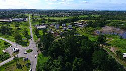 Point Fortin (in the background) | |
| Motto: Aspire to Achieve | |
 Point Fortin Location of Point Fortin  Point Fortin Point Fortin (Caribbean)  Point Fortin Point Fortin (North America) | |
| Coordinates: 10°10′N 61°40′W / 10.167°N 61.667°W | |
| Country | Trinidad and Tobago |
| Jurisdiction | Republic Borough of Point Fortin |
| Settled | 1783 |
| Borough | 24 March 1980[1] |
| Named for | A man with no recorded first name, simply called Fortin, was granted land in Trinidad. It was then called Point Fortin. |
| Government | |
| • Governing body | Point Fortin Borough Corporation |
| • Mayor | Saleema McCree Thomas, PNM |
| • Deputy Mayor | Councillor Leslie Chang Fong |
| • Chief Executive Officer | Donnamay Taylor, PNM |
| Borough Corporation seats | 6 electoral districts |
| House seats | 1/41 |
| Area | |
| • Borough | 23.88 km2 (9.22 sq mi) |
| Elevation | 9 m (30 ft) |
| Population (2011) | |
| • Borough | 20,161 |
| • Density | 809/km2 (2,100/sq mi) |
| • Urban | 29,579 |
| Time zone | UTC-4 (AST) |
| Postal Code | 64xxxx, 70xxxx[3] |
| Area code(s) | +1 (868) 648, 651, 690 |
| ISO 3166 code | TT-PTF |
| Website | pointfortinborough.com |
History and development edit
At the beginning of the 20th century (before the discovery of oil), Point Fortin was an agricultural community with three distinct and separately owned cocoa and coconut estates.
These estates were sparsely populated. Employment was provided for a small number of workers who depended on the estates for their living accommodation as well as their food and other supplies. Travel in and out of Point Fortin was by coastal steamers as there was no road into or out of the area. The inhabited area was located along the seacoast.
In 1907, the Trinidad Oilfields moved into Point Fortin on an expedition for the exploration of oil and sank its first oil well on the La Fortunee Estates. That company turned out to be the only one that survived successfully, although there had been several similar expeditions by other oil companies.
The company later changed its name to the United British Oilfields of Trinidad then became Shell Trinidad Limited. In 1974 it was acquired by the Government and named TRINTOC or the Trinidad and Tobago Oil Company, today known as Petrotrin.
The change from an agricultural to an oil based economy made a significant impact in Point Fortin. There was rapid development in the construction of dwelling houses, plant, pipelines and oil tanks in the area. Point Fortin was booming and labour, particularly skilled labour for the new technology, was scarce and posed a major problem. Trinidadians did not seem to be attracted to the area.
Although people migrated from all over the country, the population in 1931 was less than 500. There were very few houses, no schools, and recreational and other facilities. As a result, Trinidadians who went to work in Point Fortin never took their families with them.
However, this changed when the company realised that in order to attract and retain workers, they needed to develop the area. This encouraged families to settle in the area, and coupled with a growth in the commercial sector, brought about such facilities as a post office, police station as well as other governmental agencies and banks.
In the 1960s the town began to see a decline due to massive retrenchment. The Government tried to revive the economic activity and eventually succeeded in establishing the Dunlop Tyre Factory. However the economic revival was only achieved in the early 1970s as a result of the Oil boom and the acquisition of Shell Trinidad Limited by the government. Point Fortin's Mayor is Saleema McCree Thomas (PNM).[4] The MP for Point Fortin is Kennedy Richards Jr. (PNM).
Demographics edit
Ancestry edit
| Year | Pop. | ±% |
|---|---|---|
| 1980 | 16,710 | — |
| 1990 | 18,622 | +11.4% |
| 2000 | 17,755 | −4.7% |
| 2011 | 20,161 | +13.6% |
| Racial composition | 2011[5] |
|---|---|
| Black (Afro-Trinidadian/Tobagonian) | 59.5% |
| South Asian (Indo-Trinidadian) | 11.5% |
| Multiracial | 9.1% |
| Dougla (South Asian and Black) | 8.9% |
| White Trinidadian | 0.4% |
| West Asian (Chinese) | 0.12% |
| Native American (Amerindian) | 0.09% |
| Arab (Syrian/Lebanese) | - |
| Other | 0.1% |
| Not stated | 10.4% |
Notable natives edit
Culture
- Fay-Ann Lyons Alvarez – Soca Artiste
- Austin Lyons (Superblue) – Calypsonian / Soca artist/ father of Fay-Ann Lyons and her sister Terri Lyons
- Kelvin Pope (The Mighty Duke) – Calypsonian
- Keegan Taylor Soca artist/Stick Fighter
- Lady Tiny- Calypsonian
- Iwer George - Calypsonian/ Soca artist
- Naya George - Soca artiste
Sports
- Atiba Charles
- Avery John
- Kenwyne Jones
- Keyeno Thomas
- Warren Archibald
- Steve David
- Anthony Douglas
- Randy Samuel - Canadian soccer player
Public service
- Lionel Blake – first mayor
- Victor Chin Kit – past mayor
- Cyril Rogers – longest-serving MP
- John Cupid – cultural researcher
- Francis Bertrand – longest-serving mayor (Boro Day Pioneer)
Others
- Arthur Joseph - Deal or No Deal (US game show) winner
- Manchand Teeluck - professional wrestler Ring of Honor and New Japan Pro-Wrestling
- Kailash Seemegona - color commentator Ring of Honor and New Japan Pro-Wrestling
- Keston Jones - special effects assistant (Ash vs Evil Dead)
- Blake Ramires - radio co-host pirate radio podcast (US Internet radio/podcast show)
- Phillip Mitchell - radio host Univ of Hartford. CT.USA (West Indian Rhythms)WWUH
- Lance Knight - Video Game Developer/Programmer and Program Development Coordinator for Waseda University Waseda University
Education edit
Primary schools
- Point Fortin Roman Catholic Primary School
- Point Fortin S.D.A Primary School
- Egypt Village Government Primary School
- Point Fortin Anglican Primary School
- Point Fortin A.S.J.A Primary School
- Cap-de-Ville Government Primary School
- Fanny Village Government Primary School
Secondary schools
- Point Fortin East Secondary School (formally known as PFC)
- Point Fortin West Secondary School (formally known as the Junior Secondary)
- Holy Name Convent'
Other Educational/Training Institutions
- Manchand Teeluck's Squared Circle Grappling Academy - Professional Wrestling Academy
- Lu-Wong Dance Academy
- Com Sa Choi - Asian Culinary Institute
- Club Malibu - Pole Dancing Academy
Electoral districts edit
- Egypt Village
- Techier/Guapo Village
- Mahaica/New Lands Village
- Cap-De-Ville/Fanny Village
- New Village
- Hollywood Village
References edit
- ^ "Act1980_12.pdf". DIGITAL LEGISLATIVE LIBRARY. Government of Trinidad and Tobago. Retrieved 4 October 2021.
- ^ "Elevation of Point Fortin, Trinidad and Tobago Elevation Map, Topo, Contour". floodmap.net. Retrieved 5 April 2016.
- ^ "List of Postal Districts". TTPOST. 29 July 2018. Retrieved 29 July 2018.[permanent dead link]
- ^ "Councils of the PFBC". PointFortinBorough.com. Retrieved 25 March 2022.
- ^ Central Statistical Office. "NON-INSTITUTIONAL POPULATION BY SEX, AGE GROUP, ETHNIC GROUP AND MUNICIPALITY" (PDF). Archived from the original (PDF) on 19 October 2017. Retrieved 6 December 2017.
- Anthony, Michael (2001). Historical Dictionary of Trinidad and Tobago. Scarecrow Press, Inc. Lanham, Md., and London. ISBN 0-8108-3173-2.