


Summary
Point Wilson is at the end of the Quimper Peninsula, a northeast extension of the Olympic Peninsula and the northeasternmost point of Jefferson County, Washington, United States, approximately two miles north of the Port Townsend business district.
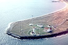
This low, broad sand-spit, extends over a half-mile into the water and marks the entrance to Admiralty Inlet from the Strait of Juan de Fuca. Here, the main shipping channel narrows and makes a sharp turn to the south into Puget Sound.
Nearby shoals, heavy rip-tides, and persistent fogs influenced the placing of a lighthouse on Point Wilson in 1879. In 1913, the present Point Wilson Lighthouse was built by the United States Lighthouse Service. The point is also the site of a meteorological station.
The Chimakum Indians named this point Kam-kam-ho and the S'Klallam Indians called it Kam-Kum. Point Wilson was discovered by Europeans on July 5, 1790 by Juan Carrasco and Manuel Quimper.[1] Captain George Vancouver of the Royal Navy named Point Wilson on June 5, 1792, in honor of a colleague, Captain George Wilson.[2]
References edit
48°8′38″N 122°45′15″W / 48.14389°N 122.75417°W