


Summary
The Polesie State Radioecological Reserve (PSRER; Belarusian: Палескі дзяржаўны радыяцыйна-экалагічны запаведнік, romanized: Palyeski dzyarzhawny radyyatsyyna-ekalahichny zapavyednik; Russian: Полесский государственный радиационно-экологический заповедник, romanized: Polessky gosudarstvenny radiatsionno-ekologichesky zapovednik) is a radioecological nature reserve in the Polesie region of Belarus, which was created to enclose the territory of Belarus most affected by radioactive fallout from the Chernobyl disaster. The reserve adjoins the Chernobyl Exclusion Zone in Ukraine. The environmental monitoring and countermeasure agency, Bellesrad, oversees the agriculture and forestry in the area.
| Polesie State Radioecological Reserve | |
|---|---|
| Палескі дзяржаўны радыяцыйна-экалагічны запаведнік (Belarusian) Полесский государственный радиационно-экологический заповедник (Russian) | |
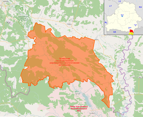 OSM map of the reserve highlighting some nearby places in the annotations (as Mazyr, Pripyat, the Chernobyl Plant etc). The map in the corner shows its position (red) within Belarus, showing also the Ukrainian, and contiguous, Chernobyl Exclusion Zone (yellow) | |
| Location | Belarus |
| Nearest city | Brahin, Narowlya, Khoiniki |
| Coordinates | 51°39′N 29°59′E / 51.650°N 29.983°E |
| Area | 2,162 km2 (835 sq mi) |
| Established | July 18, 1988[1] |
| Official website | |
History edit

Two years after the Chernobyl disaster, the Belarusian part of the Chernobyl Exclusion Zone was extended to a more highly contaminated area. Then, a closed-to-the-public nature reserve was established in Belarus with a total area of 1,313 km2 (507 sq mi). The reserve was established on July 18, 1988.[1] Before the disaster, over 22,000 people lived there in 96 settlements. The population was evacuated after the disaster. In 1993 it was expanded by 849 km2 (328 sq mi), making it the largest Belarusian nature reserve and one of the largest in Europe.
Geography edit
Overview edit
The area, located in southern Gomel Region and bordering the Ukrainian Exclusion Zone, includes part of the raions (districts) of Brahin, Khoiniki and Narowlya.[2] It is crossed by the Pripyat River, and the city of Mazyr is 36 km (22 mi) from the northwestern entrance, in Narowlya. The southern strip is crossed by the Chernihiv–Ovruch railway, which passes through the villages of Kaporanka, Kalyban and Pasudava.
Abandoned villages edit
The following list shows the abandoned villages included in the reserve. Population refers to the 1959 census. "fam." refers to the number of families evacuated after the 1986 disaster.
| Settlement |
Pop. (1959) |
Fam. (1986) |
District | Belarusian | Russian |
|---|---|---|---|---|---|
| Aravichy | 923
|
222
|
Khoiniki | Аравічы | Оревичи |
| Babchyn | 839
|
194
|
Khoiniki | Бабчын | Бабчин |
| Bagushi | 599
|
195
|
Brahin | Багушы | Богуши |
| Buda | 267
|
56
|
Khoiniki | Буда | Буда |
| Chamkou | 138
|
29
|
Khoiniki | Чамкоў | Чемков |
| Dzernavichy | 1,016
|
308
|
Narowlya | Дзёрнавічы | Дёрновичи |
| Haroshkau | 191
|
154
|
Khoiniki | Гарошкаў | Горошков |
| Kalyban | 977
|
270
|
Brahin | Калыбань | Колыбань |
| Kaporanka | 317
|
70
|
Brahin | Капоранка | Капоренка |
| Kazhushki | 869
|
214
|
Khoiniki | Кажушкі | Кожушки |
| Lomachy | 177
|
38
|
Khoiniki | Ломачы | Ломачи |
| Novakukhnaushchyna | 135
|
13
|
Khoiniki | Новакухнаўшчына | Новокухновщина |
| Novy Pakrousk | 176
|
29
|
Khoiniki | Новы Пакроўск | Новый Покровск |
| Pasudava | 642
|
73
|
Brahin | Пасудава | Посудово |
| Pirki | 552
|
476
|
Brahin | Піркі | Пирки |
| Rudyya | 245
|
40
|
Khoiniki | Рудыя | Рудые |
Fauna and flora edit

The reserve hosts many rare and endangered species, which thrive there thanks to the virtual absence of humans. They include European bison, Przewalski horse, moose, brown bear, golden eagle, and white-tailed eagle. It is home to the world's largest population of the European pond turtle. According to PSRER administration, there are 7 reptile, 11 amphibian, 46 mammal, 213 bird and 25 fish species. Of those, 70 are listed in the International Red Book and the Red Book of the Republic of Belarus. Flora includes 1251 registered plants, which is more than two-thirds of the flora of the country, and 18 of the plant species are listed in the Red Book.[3] It was found that voles have higher rates of cataracts, useful populations of bacteria on the wings of birds in the zone are lower, partial albinism is common among barn swallows, cuckoos have become less common. Serious animal mutations, though, happened only right after the accident.[4]
Activities edit
Although the reserve was established for the purpose of radiobiological and environmental research, it is of interest to other biologists. Due to the minimal human presence, it is possible to observe the natural development of wildlife in the conditions of Belarus. "In connection with the removal of anthropogenic load and the wealth of flora the ideal conditions for the recovery of the animal world have been created here", states the report of the Committee on the Health Effects of the Chernobyl disaster at the Council of Ministers of Belarus. Some new species, including European bison, have been introduced on the territory of the reserve.
Main activities edit
Administration of PSRER is located in the town of Khoiniki. The annual budget of PSRER is 4 million USD. Main activities include:[5]
- Measures to prevent radioactive material from spreading beyond the reserve's borders,
- Wildfire prevention.
- Radiation monitoring.
- Research of nuclear decontamination of soil.
- Preventing unauthorized persons from entering the reserve.
- Planting trees to prevent air and water erosion, which could spread contaminated material.
Extra-budgetary activities edit
The administration uses land in the reserve to earn income in addition to its budget. The purpose is to increase the self-sufficiency of the reserve, save money, increase the salaries of employees and contribute positively to the GDP of Belarus. Activities include:
- Forestry and woodworking, including the sale of timber, firewood, and individual carpentry orders
- Growing crops as fodder for animals or for human consumption
- Purebred horse breeding using forage resources in the reserve
- Pig farming, cattle farming, dairy farming
- Beekeeping, honey production
- Production of fruit tree seedlings
- Providing services to citizens and organizations (transport, sanitation, human decontamination, research on the concentration of radionuclides).
As of 2004, the herd at the reserve's horse farm numbered 230 horses. Cattle are being bred to endure the conditions of radioactive contamination, and young individuals are sold for further breeding.
During all activities, radionuclide concentrations are monitored to ensure they do not exceed certain limits.[6]
Neighboring nature reserves edit
Proposed for nature reserves edit
- Dnieper-Teterivske State Forestry
See also edit
References edit
- ^ a b "Polesie State Radioecological Reserve: about". Archived from the original on 2014-06-22. Retrieved 2014-06-27.
- ^ 253459229 Polesie State Radioecological Reserve on OpenStreetMap
- ^ "Общество | Гомельская область | Гомель". www.gomel-region.by (in Russian). Archived from the original on 2007-05-10. Retrieved 2018-03-31.
- ^ "Animals Rule Chernobyl Three Decades After Nuclear Disaster". National Geographic News. 2016-04-18. Archived from the original on April 18, 2016. Retrieved 2019-05-13.
- ^ "About (zapovednik.by)". Archived from the original on 2014-06-22. Retrieved 2014-06-27.
- ^ "Внебюджетная деятельность". Archived from the original on 2016-03-03. Retrieved 2014-12-30.
External links edit
- Polesie State Radiation and Ecological Reserve (official website)
- 253459229 Polesie State Radioecological Reserve on OpenStreetMap (map showing borders)
- (in Russian) Полесский государственный радиационно-экологический заповедник
- Charnobyl 30 Years Later – Belarus Photo Digest
- Chernobyl: Fact And Legacy