


Summary
Pomeroon-Supenaam (Region 2) is a region of Guyana. It borders the Atlantic Ocean to the north, the region of Essequibo Islands-West Demerara to the east, the region of Cuyuni-Mazaruni to the south and the region of Barima-Waini to the west. Pomeroon-Supenaam contains the town of Anna Regina and the villages of Charity, Pickersgill, Spring Garden and Suddie. In 2012, an Official Census by the Government of Guyana listed the population of the Pomeroon-Supenaam Region at 46,810.[2]
Pomeroon-Supenaam
Region 2 | |
|---|---|
Administrative Region | |
 | |
 Flag | |
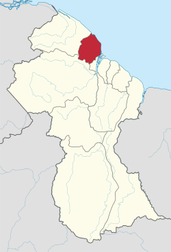 Map of Guyana showing Pomeroon-Supenaam region | |
| Country | |
| Regional Capital | Anna Regina |
| Area | |
| • Total | 6,195 km2 (2,392 sq mi) |
| Population (2012 census) | |
| • Total | 46,810 |
| • Density | 7.6/km2 (20/sq mi) |
| Time zone | UTC-4 |
| [1] | |
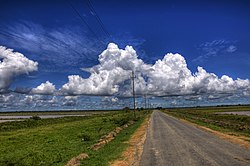
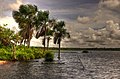
There are three lakes on the Essequibo Coast - Capoey, Mainstay and Hot and Cold. Capoey is near Anna Regina. The three lakes symbolize three of the standard elements, with earth being represented by the land.
Population edit
The Government of Guyana has administered three official censuses since the 1980 administrative reforms, in 1980, 1991 and 2002.[3] In 2002, the population of Pomeroon-Supenaam was recorded at 49,253 people.[2] Official census records for the population of the Pomeroon-Supenaam region are as follows:
- 2012 : 46,810
- 2002 : 49,253
- 1991 : 43,455
- 1980 : 42,341
Communities edit
(including name variants):[4]
- Aberdeen
- Abrams Zuil
- Adventure
- Affiance
- Akawini Mission
- Amazon
- Andrews
- Anna Regina
- Annandale
- Aurora
- Bethany
- Better Hope
- Better Success
- Bounty Hall
- Bush Lot
- Capoey
- Charity
- Columbia
- Cullen
- Danielstown
- Dartmouth
- Devonshire Castle
- Dryshore
- Fair Field
- Fear Not
- Golden Fleece (Golden Fleece Plantation)
- Hackney
- Hampton Court
- Henrietta
- Hibernia
- Huis'T Dieren
- Jacklow
- Johanna Cecilia
- Kabakaburi
- La Belle Alliance
- Land of Plenty
- Lima Sands
- Mainstay/Whyaka
- Maria's Lodge
- Middlesex
- Onderneeming
- Perseverance
- Perth
- Pomona
- Queenstown
- Reliance
- Richmond
- Saint Nicholas (Saint Nicholas Mission)
- Sirikie
- Somerset and Berks
- Sparta
- Spring Garden
- St. Monica Karawab
- Suddie
- Supenaam
- Taymouth Manor
- Three Friends
- Wakapau Village
- Walton Hall
- Windsor Castle
- Zorg
Territorial claim edit
Venezuela has renewed its claim to the Essequibo region which is situated west of the Essequibo river.[5] The status of the border controversy is subject to the Geneva Agreement, which was signed by the United Kingdom, Venezuela and British Guiana on February 17, 1966.
Gallery edit
-
 Henrietta Catholic Church
 -
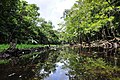
 Mainstay Lake
 -
 Lima Sands Primary School
 -
 Capoey Lake
 -
 Siriki Creek


Notable people edit
See also edit
References edit
- ^ Macmillan Publishers (2009). "Administrative Regions - 2 and 3". Macmillan Junior Atlas: Guyana. Oxford: Macmillan Caribbean. p. 34. ISBN 9780333934173.
- ^ a b Beaie, Sonkarley Tiatun (19 September 2007). "National Population Trends: Size, Growth and Distribution" (PDF Download). 2002 Population and Housing Census - Guyana National Report. Bureau of Statistics. p. 25. Retrieved 29 August 2012.
- ^ Beaie, Sonkarley Tiatun (19 September 2007). "Chapter 3: National Redistribution and Internal Migration" (PDF). 2002 Population and Housing Census - Guyana National Report. Bureau of Statistics. p. 51. Archived from the original (PDF) on 17 February 2012. Retrieved 29 August 2012.
- ^ "2012 Population by Village". Statistics Guyana. Retrieved 8 December 2021.
- ^ "Official Announcements". Archived from the original on 8 September 2016. Retrieved 28 July 2016.
7°12′N 58°48′W / 7.200°N 58.800°W