
KNOWPIA
WELCOME TO KNOWPIA

Pommereuil 
Summary
Pommereuil (French pronunciation: [pɔmʁœj]; also: Le Pommereuil) is a commune in the Nord department in northern France.[3]
Pommereuil | |
|---|---|
 A view within Pommereuil | |
 Coat of arms | |
Location of Pommereuil .mw-parser-output .locmap .od{position:absolute}.mw-parser-output .locmap .id{position:absolute;line-height:0}.mw-parser-output .locmap .l0{font-size:0;position:absolute}.mw-parser-output .locmap .pv{line-height:110%;position:absolute;text-align:center}.mw-parser-output .locmap .pl{line-height:110%;position:absolute;top:-0.75em;text-align:right}.mw-parser-output .locmap .pr{line-height:110%;position:absolute;top:-0.75em;text-align:left}.mw-parser-output .locmap .pv>div{display:inline;padding:1px}.mw-parser-output .locmap .pl>div{display:inline;padding:1px;float:right}.mw-parser-output .locmap .pr>div{display:inline;padding:1px;float:left}html.skin-theme-clientpref-night .mw-parser-output .od,html.skin-theme-clientpref-night .mw-parser-output .od .pv>div,html.skin-theme-clientpref-night .mw-parser-output .od .pl>div,html.skin-theme-clientpref-night .mw-parser-output .od .pr>div{background:#000;color:#fff}html.skin-theme-clientpref-night .mw-parser-output .locmap{filter:grayscale(0.6)}@media(prefers-color-scheme:dark){html.skin-theme-clientpref-os .mw-parser-output .locmap{filter:grayscale(0.6)}html.skin-theme-clientpref-os .mw-parser-output .od,html.skin-theme-clientpref-os .mw-parser-output .od .pv>div,html.skin-theme-clientpref-os .mw-parser-output .od .pl>div,html.skin-theme-clientpref-os .mw-parser-output .od .pr>div{background:#000;color:#fff}}  Pommereuil  Pommereuil | |
| Coordinates: 50°06′46″N 3°35′48″E / 50.1127°N 3.5967°E | |
| Country | France |
| Region | Hauts-de-France |
| Department | Nord |
| Arrondissement | Cambrai |
| Canton | Le Cateau-Cambrésis |
| Intercommunality | CA Caudrésis–Catésis |
| Government | |
| • Mayor (2020–2026) | Pascal Paquet[1] |
| Area 1 | 6.45 km2 (2.49 sq mi) |
| Population (2021)[2] | 792 |
| • Density | 120/km2 (320/sq mi) |
| Time zone | UTC+01:00 (CET) |
| • Summer (DST) | UTC+02:00 (CEST) |
| INSEE/Postal code | 59465 /59360 |
| Elevation | 91–153 m (299–502 ft) |
| 1 French Land Register data, which excludes lakes, ponds, glaciers > 1 km2 (0.386 sq mi or 247 acres) and river estuaries. | |
History edit
The village and surrounding woods (Bois l'Évêque) were heavily damaged by a tornado on 24 June 1967, a relatively rare occurrence in France.
Heraldry edit
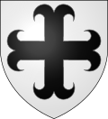 |
The arms of Pommereuil are blazoned : Argent, a cross moline sable. (Challes-les-Eaux, Montalembert, Neuvilly and Pommereuil use the same arms.)
Monuments
edit
See also editReferences edit
Wikimedia Commons has media related to Pommereuil.
|
