
KNOWPIA
WELCOME TO KNOWPIA

Pons, Charente-Maritime 
Summary
Pons (French pronunciation: [pɔ̃][3][4][5]) is a commune in the Charente-Maritime department in southwestern France. The city is known for its numerous national historic monuments dating from the 12th century onward.[6] One of the most well known is the 33 m Keep of Pons, which is the official symbol of the city.
Pons | |
|---|---|
 The Castle | |
 Coat of arms | |
Location of Pons .mw-parser-output .locmap .od{position:absolute}.mw-parser-output .locmap .id{position:absolute;line-height:0}.mw-parser-output .locmap .l0{font-size:0;position:absolute}.mw-parser-output .locmap .pv{line-height:110%;position:absolute;text-align:center}.mw-parser-output .locmap .pl{line-height:110%;position:absolute;top:-0.75em;text-align:right}.mw-parser-output .locmap .pr{line-height:110%;position:absolute;top:-0.75em;text-align:left}.mw-parser-output .locmap .pv>div{display:inline;padding:1px}.mw-parser-output .locmap .pl>div{display:inline;padding:1px;float:right}.mw-parser-output .locmap .pr>div{display:inline;padding:1px;float:left}html.skin-theme-clientpref-night .mw-parser-output .od,html.skin-theme-clientpref-night .mw-parser-output .od .pv>div,html.skin-theme-clientpref-night .mw-parser-output .od .pl>div,html.skin-theme-clientpref-night .mw-parser-output .od .pr>div{background:#000;color:#fff}html.skin-theme-clientpref-night .mw-parser-output .locmap{filter:grayscale(0.6)}@media(prefers-color-scheme:dark){html.skin-theme-clientpref-os .mw-parser-output .locmap{filter:grayscale(0.6)}html.skin-theme-clientpref-os .mw-parser-output .od,html.skin-theme-clientpref-os .mw-parser-output .od .pv>div,html.skin-theme-clientpref-os .mw-parser-output .od .pl>div,html.skin-theme-clientpref-os .mw-parser-output .od .pr>div{background:#000;color:#fff}}  Pons  Pons | |
| Coordinates: 45°34′52″N 0°32′49″W / 45.5811°N 0.5469°W | |
| Country | France |
| Region | Nouvelle-Aquitaine |
| Department | Charente-Maritime |
| Arrondissement | Jonzac |
| Canton | Pons |
| Government | |
| • Mayor (2020–2026) | Jacky Botton[1] |
| Area 1 | 27.63 km2 (10.67 sq mi) |
| Population (2021)[2] | 4,273 |
| • Density | 150/km2 (400/sq mi) |
| Time zone | UTC+01:00 (CET) |
| • Summer (DST) | UTC+02:00 (CEST) |
| INSEE/Postal code | 17283 /17800 |
| Elevation | 8–63 m (26–207 ft) |
| 1 French Land Register data, which excludes lakes, ponds, glaciers > 1 km2 (0.386 sq mi or 247 acres) and river estuaries. | |
Geography edit
The Seugne flows north through the middle of the city and crosses it..
Population edit
|
| ||||||||||||||||||||||||||||||||||||||||||||||||||||||||||||||||||||||||||||||||||||||||||||||||||||||||||||||||||
| Source: EHESS[7] and INSEE (1968-2017)[8] | |||||||||||||||||||||||||||||||||||||||||||||||||||||||||||||||||||||||||||||||||||||||||||||||||||||||||||||||||||
Gallery edit
-
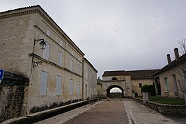 Pilgrim hospital, via Turonensis, World Heritage, way of st-James.
 -
 Keep.
Keep. -
 Museum.
 -
![Château d'Usson, a medieval theme-park for children[9]](//upload.wikimedia.org/wikipedia/commons/thumb/a/a6/Le_Ch%C3%A2teau_des_%C3%A9nigmes_en_Charente-Maritime_%2817%29.JPG/271px-Le_Ch%C3%A2teau_des_%C3%A9nigmes_en_Charente-Maritime_%2817%29.JPG) Château d'Usson, a medieval theme-park for children[9]
Château d'Usson, a medieval theme-park for children[9] -
 church.
 -

-
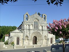
 Church.


![Château d'Usson, a medieval theme-park for children[9]](http://upload.wikimedia.org/wikipedia/commons/thumb/a/a6/Le_Ch%C3%A2teau_des_%C3%A9nigmes_en_Charente-Maritime_%2817%29.JPG/271px-Le_Ch%C3%A2teau_des_%C3%A9nigmes_en_Charente-Maritime_%2817%29.JPG)


See also edit
References edit
- ^ "Répertoire national des élus: les maires" (in French). data.gouv.fr, Plateforme ouverte des données publiques françaises. 13 September 2022.
- ^ "Populations légales 2021". The National Institute of Statistics and Economic Studies. 28 December 2023.
- ^ "Tous les chemins mènent à vous" à Pons en Charente-Maritime, archived from the original on 21 December 2021, retrieved 16 July 2021
- ^ Souvenirs en Charente-Maritime : la ville de Pons reconstitue les embouteillages de la nationale 137, archived from the original on 21 December 2021, retrieved 16 July 2021
- ^ Charente-Maritime : démissions au conseil municipal de Pons, archived from the original on 21 December 2021, retrieved 16 July 2021
- ^ Joy, Diane (2005). "Charente-Maritime. Pons, inventaire du patrimoine médiéval de la ville". Bulletin Monumental. 163 (4): 375–378. doi:10.3406/bulmo.2005.1580.
- ^ Des villages de Cassini aux communes d'aujourd'hui: Commune data sheet Pons, EHESS (in French).
- ^ Population en historique depuis 1968, INSEE
- ^ Travel, D. K. (17 May 2016). Family Guide France - DK Travel - Google Books. ISBN 9781465455260. Retrieved 21 December 2018.
{{cite book}}:|newspaper=ignored (help)
External links edit
Wikimedia Commons has media related to Pons (Charente-Maritime).
- Official website for the city of Pons (French)