
KNOWPIA
WELCOME TO KNOWPIA

Ponsorimalai 
Summary
Ponsorimalai, also known as Sorimalai, is a hill in Vennandur block of Namakkal district in Tamil Nadu, India.
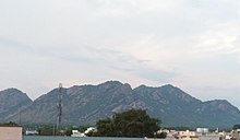
| Sorimalai | |
|---|---|
 Aerial view of Vennandur block, view of Ponsorimalai and beyond that view of Kanjamalai from Alavaimalai | |
| Highest point | |
| Coordinates | 11°32′48.9″N 78°06′19.6″E / 11.546917°N 78.105444°E |
| Dimensions | |
| Length | 2.575 km (1.600 mi) N–S |
| Width | 2.253 km (1.400 mi) E–W |
| Area | 5.8 km2 (2.2 sq mi) |
| Naming | |
| English translation | Ponsorimalai- பொன்சொரிமலை |
| Language of name | Tamil |
| Geography | |
| Location | Ponparappipatti |
| Parent range | part of the Eastern Ghats |
| Climbing | |
| Easiest route | Vennandur-Mallur Road |
Geology edit
Ponsorimalai[1] is located northwest of Alavaimalai[2] and southeast of Kanjamalai.[3] North and West side foot hill limits are surrounded by villages of Salem district, South and East side foot hill limits are surrounded by villages of Namakkal district.

History edit
A 15th-century Jain inscriptions in the hills bear couplet 251 from the “Shunning meat” chapter (Chapter 26) of the Kural text, indicating that the people of the Kongu Nadu region practiced ahimsa and non-killing as chief virtues.[4]
References edit