
KNOWPIA
WELCOME TO KNOWPIA

Popovo Saddle 
Summary
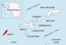
Popovo Saddle (Bulgarian: Поповска седловина, ‘Popovska Sedlovina’ \'po-pov-ska se-dlo-vi-'na\) is the saddle of elevation 1550 m in Imeon Range on Smith Island in the South Shetland Islands, Antarctica bounded by Drinov Peak to the north and Sevlievski Peak to the south. Overlooking Ovech Glacier to the east and Chuprene Glacier to the southwest.

The saddle is named after the town of Popovo in northeastern Bulgaria.
Location edit
Popovo Saddle is located at 62°57′34″S 62°29′24″W / 62.95944°S 62.49000°W. Bulgarian mapping in 2009.
Maps edit
- Chart of South Shetland including Coronation Island, &c. from the exploration of the sloop Dove in the years 1821 and 1822 by George Powell Commander of the same. Scale ca. 1:200000. London: Laurie, 1822.
- L.L. Ivanov. Antarctica: Livingston Island and Greenwich, Robert, Snow and Smith Islands. Scale 1:120000 topographic map. Troyan: Manfred Wörner Foundation, 2010. ISBN 978-954-92032-9-5 (First edition 2009. ISBN 978-954-92032-6-4)
- South Shetland Islands: Smith and Low Islands. Scale 1:150000 topographic map No. 13677. British Antarctic Survey, 2009.
- Antarctic Digital Database (ADD). Scale 1:250000 topographic map of Antarctica. Scientific Committee on Antarctic Research (SCAR). Since 1993, regularly upgraded and updated.
- L.L. Ivanov. Antarctica: Livingston Island and Smith Island. Scale 1:100000 topographic map. Manfred Wörner Foundation, 2017. ISBN 978-619-90008-3-0
References edit
- Popovo Saddle. SCAR Composite Gazetteer of Antarctica.
- Bulgarian Antarctic Gazetteer. Antarctic Place-names Commission. (details in Bulgarian, basic data in English)
External links edit
- Popovo Saddle. Copernix satellite image

This article includes information from the Antarctic Place-names Commission of Bulgaria which is used with permission.