


Summary
Port Murray is an unincorporated community and census-designated place (CDP)[10] located within Mansfield Township in Warren County, in the U.S. state of New Jersey, that was created as part of the 2010 United States Census.[11][12][13][14] As of the 2010 Census, the CDP's population was 129.[15]
Port Murray, New Jersey | |
|---|---|
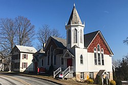 Historic buildings on Main Street | |
 United States Census Bureau map of ZCTA 07865 Port Murray, New Jersey | |
 Port Murray Location in Warren County  Port Murray Location in New Jersey  Port Murray Location in the United States | |
| Coordinates: 40°47′37″N 74°54′49″W / 40.793505°N 74.913547°W[1][2] | |
| Country | |
| State | |
| County | Warren |
| Township | Mansfield |
| Named for | James Boyles Murray |
| Area | |
| • Total | 0.99 sq mi (2.56 km2) |
| • Land | 0.99 sq mi (2.56 km2) |
| • Water | 0.00 sq mi (0.00 km2) 0.57% |
| Elevation | 633 ft (193 m) |
| Population | |
| • Total | 227 |
| • Density | 229.52/sq mi (88.65/km2) |
| Time zone | UTC−05:00 (Eastern (EST)) |
| • Summer (DST) | UTC−04:00 (EDT) |
| ZIP Code | 07865[6] |
| Area code | 908 |
| FIPS code | 34-60450[1][7][8] |
| GNIS feature ID | 02584020[1][9] |
The community was long known by this name for its location on the Morris Canal and after Colonel James Boyles Murray, the third president of the Morris Canal and Banking Company.[16]
The area is served as United States Postal Service ZIP Code 07865.[6]
Geography edit
According to the United States Census Bureau, the CDP had a total area of 0.168 square miles (0.435 km2), including 0.167 square miles (0.433 km2) of land and 0.001 square miles (0.002 km2) of water (0.57%).[1][2]
Demographics edit
| Census | Pop. | Note | %± |
|---|---|---|---|
| 2010 | 129 | — | |
| 2020 | 227 | 76.0% | |
| U.S. Decennial Census[17] 2010[15] 2020[5] | |||
2000 census edit
As of the 2000 United States Census, the population for ZIP Code Tabulation Area 07865 was 2,010.[18]
2010 census edit
The 2010 United States census counted 129 people, 57 households, and 39 families in the CDP. The population density was 772.2 per square mile (298.1/km2). There were 63 housing units at an average density of 377.1 per square mile (145.6/km2). The racial makeup was 97.67% (126) White, 1.55% (2) Black or African American, 0.00% (0) Native American, 0.00% (0) Asian, 0.00% (0) Pacific Islander, 0.00% (0) from other races, and 0.78% (1) from two or more races. Hispanic or Latino of any race were 1.55% (2) of the population.[15]
Of the 57 households, 21.1% had children under the age of 18; 56.1% were married couples living together; 5.3% had a female householder with no husband present and 31.6% were non-families. Of all households, 22.8% were made up of individuals and 5.3% had someone living alone who was 65 years of age or older. The average household size was 2.26 and the average family size was 2.64.[15]
14.7% of the population were under the age of 18, 7.0% from 18 to 24, 23.3% from 25 to 44, 35.7% from 45 to 64, and 19.4% who were 65 years of age or older. The median age was 48.1 years. For every 100 females, the population had 126.3 males. For every 100 females ages 18 and older there were 120.0 males.[15]
Transportation edit
Port Murray had a station on the Morris and Essex Railroad, located 67 miles (108 km) west of New York City.[19]
Historic district edit
The Port Murray Historic District was added to the National Register of Historic Places on June 7, 1996.[20]
Notable people edit
People who were born in, residents of, or otherwise closely associated with Port Murray include:
- John Eugene Kunzler (1923– 2006), scientist and physicist who conducted pioneering research into the field of superconducting magnets.[21]
Gallery edit
-
 Canal Store on the Morris Canal
 -
 Post office consisting of a one-story trailer
 -
 Former station on the Morris and Essex Railroad
 -


References edit
- ^ a b c d Gazetteer of New Jersey Places, United States Census Bureau. Accessed July 21, 2016.
- ^ a b US Gazetteer files: 2010, 2000, and 1990, United States Census Bureau. Accessed September 4, 2014.
- ^ "ArcGIS REST Services Directory". United States Census Bureau. Retrieved October 11, 2022.
- ^ U.S. Geological Survey Geographic Names Information System: Port Murray Census Designated Place, Geographic Names Information System. Accessed June 3, 2013
- ^ a b Census Data Explorer: Port Murray CDP, New Jersey, United States Census Bureau. Accessed June 15, 2023.
- ^ a b Look Up a ZIP Code for Port Murray, NJ, United States Postal Service. Accessed June 3, 2013.
- ^ U.S. Census website, United States Census Bureau. Accessed September 4, 2014.
- ^ Geographic codes for New Jersey, Missouri Census Data Center. Accessed June 9, 2023.
- ^ US Board on Geographic Names, United States Geological Survey. Accessed September 4, 2014.
- ^ State of New Jersey Census Designated Places - BVP20 - Data as of January 1, 2020, United States Census Bureau. Accessed December 1, 2022.
- ^ GCT-PH1 - Population, Housing Units, Area, and Density: 2010 - County -- County Subdivision and Place from the 2010 Census Summary File 1 for Warren County, New Jersey Archived 2020-02-12 at archive.today, United States Census Bureau. Accessed June 4, 2013.
- ^ 2006-2010 American Community Survey Geography for New Jersey, United States Census Bureau. Accessed June 4, 2013.
- ^ New Jersey: 2010 - Population and Housing Unit Counts - 2010 Census of Population and Housing (CPH-2-32), United States Census Bureau, p. III-5, August 2012. Accessed June 4, 2013. "Warren County—Name Changes: Beattystown CDP name corrected from Beatyestown; New CDPs: Allamuchy (formed from part of deleted Allamuchy-Panther Valley CDP), Anderson, Asbury, Blairstown, Brainards, Bridgeville, Broadway, Brookfield, Buttzville, Columbia, Delaware, Delaware Park, Finesville, Great Meadows (formed from part of deleted Great Meadows-Vienna CDP and additional area), Greenwich, Hainesburg, Harmony, Hope, Hutchinson, Johnsonburg, Lopatcong Overlook, Marksboro, Mountain Lake, Mount Hermon, New Village, Panther Valley (formed from part of deleted Allamuchy-Panther Valley CDP), Port Colden, Port Murray, Silver Lake, Stewartsville, Upper Pohatcong, Upper Stewartsville, and Vienna (formed from part of deleted Great Meadows-Vienna and additional area)"
- ^ Locality Search, State of New Jersey. Accessed April 19, 2015.
- ^ a b c d e DP-1 - Profile of General Population and Housing Characteristics: 2010 Demographic Profile Data for Port Murray CDP, New Jersey Archived 2020-02-12 at archive.today, United States Census Bureau. Accessed June 3, 2013.
- ^ Goller, Robert R. The Morris Canal: Across New Jersey by Water and Rail, p. 34. Arcadia Publishing, 1999. ISBN 0738500763.
- ^ Census of Population and Housing, United States Census Bureau. Accessed June 1, 2023.
- ^ DP-1 Profile of General Demographic Characteristics: 2000 more information Census 2000 Summary File 1 (SF 1) 100-Percent Data for ZCTA5 07865 Archived 2020-02-12 at archive.today, United States Census Bureau. Accessed June 3, 2013.
- ^ Travelers' Official Guide of the Railways; June 1, 1870: National Railway Publication Company.
- ^ Greiff, Constance M. (December 1994). "National Register of Historic Places Inventory/Nomination: Port Murray Historic District". National Park Service. With accompanying 22 photos
- ^ "Alumni 1950:", p. 37, Catalyst Magazine of the University of California, Berkeley, June 16, 2015. Accessed March 30, 2023. "We have learned from his daughter, Marilyn Barber, that John Eugene Kunzler (Ph.D. Chem) passed away on Najuary 11, 2006, after a brief battle with cancer... He had made his home in Port Murray, NJ."