
-
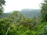
 Port St. Johns and the Umzimvubu River mouth from Mount Thesiger
 -
 Port St. Johns flora
 -
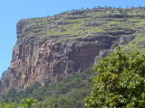 Mount Thesiger

KNOWPIA
WELCOME TO KNOWPIA
Port St. Johns 
Summary
Port St. Johns (or Port Saint Johns) is a town of about 6,500 people on the Wild Coast in the Eastern Cape province of South Africa. It is situated at the mouth of the Umzimvubu River, 220 kilometres (140 mi) northeast of East London and 70 kilometres (40 mi) east of Mthatha. Port St. Johns was the birthplace of Capital Radio 604.
Port St. Johns | |
|---|---|
 The town centre | |
 Port St. Johns  Port St. Johns  Port St. Johns | |
| Coordinates: 31°37′44″S 29°32′13″E / 31.6288°S 29.5369°E | |
| Country | South Africa |
| Province | Eastern Cape |
| District | O.R. Tambo |
| Municipality | Port St Johns |
| Area | |
| • Total | 8.03 km2 (3.10 sq mi) |
| Elevation | 7 m (23 ft) |
| Population (2011)[1] | |
| • Total | 6,441 |
| • Density | 800/km2 (2,100/sq mi) |
| Racial makeup (2011) | |
| • Black African | 94.7% |
| • Coloured | 3.5% |
| • Indian/Asian | 0.6% |
| • White | 1.1% |
| • Other | 0.1% |
| First languages (2011) | |
| • Xhosa | 89.7% |
| • English | 6.2% |
| • Other | 4.1% |
| Time zone | UTC+2 (SAST) |
| Postal code (street) | 5120 |
History edit
This town is thought to have been named after a Portuguese ship (the São João),[2] which was actually wrecked at Port Edward.[3] Later seafarers mistakenly identified the mouth of the Umzimvubu River as the site of this wreck.[2]
In the mid-1800s the local Mpondo Chief, Ndamase, allowed a few white traders to settle at the mouth of the Umzimvubu River. When Chief Ndamase died in 1876, the Mpondo Great House in Lusikisiki tried to take over the area. On 17 July 1878, Chief Ndamase's oldest son Nqwiliso, reacted by ceding the western bank of the Umzimvubu River to the Cape Colony in return for being recognised as an independent ruler and he and his people were promised protection.[4][5] The river mouth was used as a port, however this activity was abandoned in the 1940s due to siltation, which caused the river to become too shallow for vessels.
The town was the principal port of the defunct Republic of Transkei (1976-1994).
Geography, climate and geology edit

Port St. Johns is situated on the Wild Coast on a coastline of about 270 km long. It lies at the mouth of the Mzimvubu River, a river flowing through a gorge known as the "Gates of St John" into an estuary located on the Indian Ocean. On both sides of the river ravine are high sandstone mountain peaks: Mount Thesiger (342 metre above sea level) and Mount Sullivan (304 metre), named after two British Military officers.
It is the main settlement in the Port St. Johns Local Municipality which forms part of the O.R. Tambo District Municipality in Pondoland of the former Transkei. According to the 2011 census it had a population of 6,441, of whom 90% where Xhosa-speaking.[1]
In the area near the town, some of the most significant Travertine deposits in South Africa are found. About 10 km west of Port St. Johns, sandstone is excavated for architectural use.[6]
The climate is humid subtropical (Köppen: Cfa).
| Climate data for Port St. Johns | |||||||||||||
|---|---|---|---|---|---|---|---|---|---|---|---|---|---|
| Month | Jan | Feb | Mar | Apr | May | Jun | Jul | Aug | Sep | Oct | Nov | Dec | Year |
| Record high °C (°F) | 31.7 (89.1) |
32.8 (91.0) |
35.0 (95.0) |
34.4 (93.9) |
34.4 (93.9) |
32.8 (91.0) |
33.9 (93.0) |
36.5 (97.7) |
39.2 (102.6) |
41.1 (106.0) |
37.7 (99.9) |
33.5 (92.3) |
41.1 (106.0) |
| Mean daily maximum °C (°F) | 25.1 (77.2) |
25.4 (77.7) |
24.8 (76.6) |
24.0 (75.2) |
23.1 (73.6) |
22.0 (71.6) |
21.4 (70.5) |
21.1 (70.0) |
21.2 (70.2) |
21.7 (71.1) |
22.9 (73.2) |
24.3 (75.7) |
23.1 (73.6) |
| Daily mean °C (°F) | 22.4 (72.3) |
22.7 (72.9) |
22.0 (71.6) |
20.8 (69.4) |
19.4 (66.9) |
18.0 (64.4) |
17.4 (63.3) |
17.5 (63.5) |
18.1 (64.6) |
18.9 (66.0) |
20.1 (68.2) |
21.4 (70.5) |
19.9 (67.8) |
| Mean daily minimum °C (°F) | 19.6 (67.3) |
19.9 (67.8) |
19.2 (66.6) |
17.6 (63.7) |
15.7 (60.3) |
14.0 (57.2) |
13.4 (56.1) |
13.9 (57.0) |
15.0 (59.0) |
16.0 (60.8) |
17.3 (63.1) |
18.7 (65.7) |
16.7 (62.1) |
| Record low °C (°F) | 12.2 (54.0) |
11.1 (52.0) |
8.2 (46.8) |
11.1 (52.0) |
8.9 (48.0) |
5.6 (42.1) |
6.7 (44.1) |
6.1 (43.0) |
6.7 (44.1) |
7.8 (46.0) |
7.2 (45.0) |
7.9 (46.2) |
5.6 (42.1) |
| Average precipitation mm (inches) | 117 (4.6) |
130 (5.1) |
147 (5.8) |
86 (3.4) |
66 (2.6) |
38 (1.5) |
40 (1.6) |
49 (1.9) |
87 (3.4) |
119 (4.7) |
120 (4.7) |
121 (4.8) |
1,120 (44.1) |
| Average precipitation days (≥ 0.1 mm) | 14.3 | 12.3 | 11.9 | 8.6 | 5.7 | 3.4 | 4.6 | 6.0 | 9.1 | 13.5 | 14.0 | 14.2 | 117.6 |
| Average relative humidity (%) (at 14:00) | 80 | 80 | 81 | 76 | 72 | 65 | 66 | 70 | 75 | 78 | 80 | 79 | 75 |
| Source: Deutscher Wetterdienst[7] | |||||||||||||
Tourism and road access edit
Port St. Johns is known as the centre of tourism on the Wild Coast.[2] It is known for deep sea fishing and shore angling. Near to the town are three beaches.
From Mthatha in the West and Flagstaff in the North the R61 road connects to Port St. Johns. A smaller road leads the last 5 km into town. Port St. Johns has an airstrip on top of Mount Thesiger.
The Pondoland Park is a National park and forested area 500 km2 in size, including the Umzimvubu river mouth and stretching north along the coast up to the provincial border with KwaZulu-Natal.[8]
Tours targeting world famous "sardine run" are popular as well.[9]
Port St. Johns


See also edit
References edit
- ^ a b c d e "Main Place Port St. Johns". Census 2011.
- ^ a b c van der Merwe, E. and Costello, K. Port St. Johns, "Paradise in Pondoland" (2nd edition).
- ^ About.com African History: 8 June 1552 – Portuguese Ship São João Wrecked off the KwaZulu Coast: http://africanhistory.about.com/b/2008/06/08/8-june-1552-portuguese-ship-sao-joao-wrecked-off-the-kwazulu-coast.htm, retrieved 17 August 2011.
- ^ "Nqwiliso cedes land to Cape Government | South African History Online".
- ^ "History - Port St Johns". 12 March 2020.
- ^ Travertine - Port St Johns, Eastern Cape. auf www.geoscience.org.za
- ^ "Klimatafel von Cape Hermes / Saint Johns; Prov. Eastern Cape / Südafrika" (PDF). Baseline climate means (1961–1990) from stations all over the world (in German). Deutscher Wetterdienst. Retrieved 19 November 2016.
- ^ "National park for the Wild Coast - SouthAfrica.info". Archived from the original on 2012-09-02. Retrieved 2012-05-19.
- ^ Offshore Africa Port St. Johns. Sardine Run ocean safari. Retrieved on October 01, 2017
External links edit
Wikimedia Commons has media related to Port St. Johns.
 Port St Johns travel guide from Wikivoyage
- Port St Johns Municipality
- Walking trails in and around Port St Johns, planned and mapped by Ben Dekker (archived).