


Summary
Porters, is a commercial ski resort just over an hour's drive (98 km) west from Christchurch, in the South Island of New Zealand. Originally functioning as a club skifield, it has one beginner magic carpet, one platter tow, one chairlift and three t-bars. The difficulty of the slopes is distributed as 15% beginner, 35% intermediate and 50% advanced. Modern grooming equipment is used, and snowmaking facilities operate along the main pistes along the chairlift.
| Porters | |
|---|---|
 | |
| Location | Selwyn Canterbury |
| Nearest major city | Springfield |
| Coordinates | 43°16′26″S 171°38′34″E / 43.273792°S 171.642778°E |
| Vertical | 620 m |
| Top elevation | 1995 m (6545 ft) 'Allison Peak' 43°15′45″S 171°37′53″E / 43.26259°S 171.63129°E |
| Base elevation | 1302 m (4272 ft) |
| Skiable area | 700 Ha |
| Trails | 29 |
| Longest run | 2km - McNulty's Basin |
| Lift system | 6 lifts: 3 T-bar lifts, 1 Platter lift, 1 Magic carpet, 1 Chairlift |
| Terrain parks | 1 |
| Snowmaking | Yes |
| Night skiing | No |
| Website | https://portersalpineresort.com/ |

There is one club-run lodge with 42 beds, situated along on the mountain's access road, said by the company operating the field to be "the least intimidating in Canterbury".[1]
With poor snow fall between 1987 and 1990, Porters became the first skifield in New Zealand to install snow making in 1991.[2]
In 2007 the name of the field changed from Porter Heights to simply Porters to reflect a change in ownership. By 2020 it was again rebranded as Porters Alpine Resort.[3] This has brought various improvements to the field, including a new groomer, cafe and platter lift.[4]
In 2011 a proposed land swap attracted controversy. Blackfish, the Australian company that owns the ski field, offered to swap 70 ha of land on Banks Peninsula for 198 ha of conservation land adjacent to the ski field. Alan Morrison, the director general of the Department of Conservation, agreed to the land swap in principle. The land swap is opposed by the Canterbury Aoraki Conservation Board and by Forest and Bird.[5]
Porters wish to expand into the adjoining Crystal Valley, which has better snow coverage.[6][7][8]
In 2015 Porters had plans for a $60m gondola and $100m hotel complex. These have yet to be developed. Porters wishes to grow the operation to a year round business and has plans to install zip lines, hot pools, mountain biking trails and hiking.[9] Currently, Porters has 2.3 km of purpose-built mountain bike flow trails. With a vertical climb of 120 metres.[citation needed]
On Friday 22 July 2021, Porters had one of its biggest days ever during the July school holidays with 1200 people skiers. This was bigger that the 2020 holiday maximum of 900 skiers and also greater than the 2020 July school holiday average of 501 daily skiers.[10]
Geography edit
Porters Ski Area is located at the southern end of the Craigieburn Range in the South Island of New Zealand. The Craigieburn Range is situated 85 km northwest of Christchurch and an equal distance from both the west and east coast of the South Island. The range is orientated northeast to southwest and extends for 26 km. The geology and topography of the Craigieburn Range is typical of much of the eroded alpine land east of the Main Divide with folded indurated sandstones and siltstones forming rounded ridge tops. Many of the slopes are still very active due to numerous shatter belts within the highly jointed bedrock resulting in the predominantly scree-covered terrain. Although valley glaciations would have been extensive in the Late Pleistocene, most evidence of this has been severely modified due to fluvial erosion and talus deposition. The ski area consists of approximately 80% of this scree with the remaining cover being alpine vegetation.
Statistics edit
Elevation edit
- Summit 1995 m (6545 ft) 43°15′45″S 171°37′53″E / 43.26259°S 171.63129°E
- Base 1302 m (4272 ft) 43°16′26″S 171°38′34″E / 43.273792°S 171.642778°E
Lifts edit
- T-Bar 3
- Doppelmayr
- 1740 m - 1955 m (5709 ft - 6414 ft); 43°16′20″S 171°37′45″E / 43.272094°S 171.629146°E
- T-Bar 2
- Doppelmayr
- 1580 m - 1780 m (5184 ft - 5840 ft); 43°16′15″S 171°37′59″E / 43.270868°S 171.63318°E
- 1 T-Bar
- 1305 m - 1625 m (4281 ft - 5331 ft); 43°16′23″S 171°38′34″E / 43.273094°S 171.642707°E
- 1 Quad Chair (replaced T bar in 2015)
- Doppelmayr
- carrying capacity is 2000 people per hour (6:10 minutes)
- Doppelmayr
- 1 Platter
- 1305 m - 1340 m (4281 ft - 4396 ft); 43°16′21″S 171°38′38″E / 43.272461°S 171.643887°E
- 1 Magic carpet
- 43°16′19″S 171°37′45″E / 43.272079°S 171.629146°E
Trails edit
| Trail Name | Trail Rating | Incline | Length | Description |
|---|---|---|---|---|
| Beginner Area |  |
0.1 km | Beginner Area is founded just above the car park | |
| Easy Street |  |
1.1 km | Easy Street is founded just above the car park | |
| Intermediate Area | |
0.2 km | Intermediate Area is founded just above the car park | |
| Dome Face |  |
1.2 km | Dome Face is the large open slope above the old cafe and the ski patrol building | |
| Big Mama | |
31° - 37° | 1.2 km | Big Mama is the large open slope on the true left of Dome Face, which runs down from the boundary ridge to the base area |
| Babylon | |
31° - 36° | 0.3 km | Babylon is small open slope that breaks off the main ridge about halfway down, directly above tower-5 of T-Bar 1 |
| Ridge Route | |
32° - 35° | 0.8 km | Ridge Route is large open slope that is running down from the top main ridge |
| Julian's Bowl | |
25° - 30° | 0.5 km | Julian's Bowl the obvious Y-shaped bowl below the T-Bar 3 drive station. It is bound by T-Bar 2 lift track on the true left |
| Headwall | |
18° - 37° | 0.5 km | Headwall is large open slope on the true right side of T-Bar 3 lift line |
| Sundance Basin | |
20° - 30° | 0.7 km | Sundance Basin is the groomed ski run for T-Bar 3, the slope on the true left of T-Bar 3 lift line |
| JC's | |
29° - 39° | 0.4 km | JC's is the slope from the main ski run on T-Bar 3 to about half way the bowl |
| Leaper | |
22° - 40° | 0.9 km | Leaper is the slope from about halfway between the large rock buttress in JC's and to the small gullies above the top of T-Bar 2 |
| Aorangi Chutes | |
28° - 35° | 0.6 km | Aorangi Chutes is the area where the slope is made up of multiple narrow gullies and rocky outcrops above T-Bar 1 |
| Solitude | |
21° - 35° | 0.6 km | Solitude is the slope between the rocky outcrops of Aorangi Chutes and McNulty's Saddle |
| McNulty's Basin | |
2.0 km | McNulty's Basin is the groomed trail from top T-Bar 3 through McNulty's Basin | |
| Serpent | |
21° - 29° | 0.3 km | Serpent is the slope below the saddle and the first section of the ridge walk to Bluff Face |
| Jelly Roll | |
30° - 33° | 0.5 km | Jelly Roll is the slope midsection of the ridge walk to Bluff Face |
| Pot Belly | |
29° - 35° | 0.5 km | Pot Belly is located in McNulty's Basin below the Ridge Walk to Bluff Face, the prominent steep open slope below the summit of 'Allison Peak' |
| Uli's Roll | |
0.5 km | Uli's Roll is located in McNulty's Basin below the summit of 'Allison Peak' | |
| Zodiac Traverse | |
0.7 km | Zodiac Traverse is wider open section below the Allison Peak summit | |
| Scorpio | |
0.7 km | Scorpio is the large open slope in McNulty's Basin on the true right of the prominent rock buttresses, which border onto Libra and the upper part of Bluff Face | |
| Libra | |
0.7 km | Libra is the open slope between the two prominent, parallel rocky ridges, which run down between Scorpio and Bluff Face | |
| Stellar Bowl | |
30° - 40° | 0.3 km | Stellar Bowl is the area below the triangular shaped group of rock buttresses on the true right of Libra |
| Stan's | |
0.4 km | Stan's is the slope directly below the prominent, low buttress between Libra and Bluff Face | |
| Pisces | |
30° - 40° | 0.3 km | Pisces is the slope directly below the lowest rock buttress on the small ridgeline that runs down from Bluff Face true left side |
| Bluff Face | |
34° - 42° | 1.2 km | Bluff Face is the large open face on the true left of the ski area with large prominent rock buttresses at the top. |
| Laurie's Face | |
33° - 37° | 0.5 km | Laurie's Face is the large open slope below the skyline ridge that sweeps down from the true left of Bluff Face |
| Don't Miss | |
0.5 km | Don't Miss is the slope on the true left of the car park, which is made up of numerous rocks and rocky outcrops of moderate to large size and multiple gullies ranging from very narrow to middle width | |
| Sphinx | |
0.4 km | The Sphinx is located on the slopes above the snow groomer workshop and the access track |
Climate edit
There are two principal storm systems that influence Porter Ski Area. The typical storm involves the passage of a southwest frontal band. Warm, gusty west to northwest winds precede the frontal passage with a change to cooler south to southwest winds following behind. The second storm type involves a deepening depression that moves across central New Zealand to lie off the East Coast of the South Island. Such a system feeds a moist east to southeast airflow into the Craigieburn region. Prowse[11] and McGregor[12] suggest that the majority of seasonal snow accumulations along the Craigieburn Range are associated with typical northwest-turning southerly storm cycles, due to the proximity of the range to the Southern Alps.
The coldest dry-bulb temperature ever recorded at Porters Ski Area was on 14 August 2011 at 23:35:48 at −15.37 °C (4.33 °F; 257.78 K).
| Climate data for Porters Area Ski @ 1,320 m | |||||||||||||
|---|---|---|---|---|---|---|---|---|---|---|---|---|---|
| Month | Jan | Feb | Mar | Apr | May | Jun | Jul | Aug | Sep | Oct | Nov | Dec | Year |
| Record high °C (°F) | 26.6 (79.9) |
26.0 (78.8) |
24.7 (76.5) |
19.3 (66.7) |
15.9 (60.6) |
13.5 (56.3) |
14.2 (57.6) |
15.8 (60.4) |
16.0 (60.8) |
18.4 (65.1) |
23.4 (74.1) |
23.8 (74.8) |
26.6 (79.9) |
| Mean daily maximum °C (°F) | 22 (72) |
22 (72) |
21 (70) |
16 (61) |
14 (57) |
9 (48) |
9 (48) |
13 (55) |
13 (55) |
15 (59) |
22 (72) |
23 (73) |
17 (62) |
| Daily mean °C (°F) | 11 (52) |
11 (52) |
10 (50) |
7 (45) |
4 (39) |
2 (36) |
1 (34) |
2 (36) |
4 (39) |
4 (39) |
7 (45) |
9 (48) |
6 (43) |
| Mean daily minimum °C (°F) | 0 (32) |
−1 (30) |
−1 (30) |
−3 (27) |
−5 (23) |
−8 (18) |
−7 (19) |
−7 (19) |
−6 (21) |
−4 (25) |
−3 (27) |
−1 (30) |
−4 (25) |
| Record low °C (°F) | −2.3 (27.9) |
−0.8 (30.6) |
−4.4 (24.1) |
−5.3 (22.5) |
−7.2 (19.0) |
−8.3 (17.1) |
−10.9 (12.4) |
−11.4 (11.5) |
−8.0 (17.6) |
−7.6 (18.3) |
−5.9 (21.4) |
−4.2 (24.4) |
−11.4 (11.5) |
| Average precipitation mm (inches) | 62 (2.4) |
94 (3.7) |
40 (1.6) |
82 (3.2) |
131 (5.2) |
157 (6.2) |
132 (5.2) |
149 (5.9) |
104 (4.1) |
125 (4.9) |
61 (2.4) |
92 (3.6) |
1,229 (48.4) |
| Average precipitation days | 13 | 12 | 11 | 11 | 12 | 17 | 16 | 18 | 18 | 16 | 11 | 15 | 170 |
| Average relative humidity (%) | 67 | 69 | 68 | 70 | 69 | 66 | 66 | 70 | 66 | 66 | 67 | 72 | 68 |
| Source: Data from an automatic weather station between 2005 and October 2015 | |||||||||||||
Flora edit
187 plant species can be found within the ski field boundary.[13]
- Porters Ski Area (2023)
-
 Sundance Valley (2023)
 -
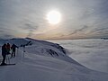 View from the top of the ski field above the clouds (2023)


Fauna edit
During the summer months five species of grasshoppers can be found within the ski field boundary. They include Sigaus villosus which can be found along the ridgelines, Brachaspis nivalis which lives on the rocky scree, Sigaus australis, Paprides nitidus which both live in the alpine tussocklands and Phaulacridium marginale which can be found in the tussocklands below 1,100 m.[14]
References edit
- ^ Porters Ski Area - skiing, snowboarding - south island new zealand - skiing, snowboarding Archived 2007-09-28 at the Wayback Machine
- ^ Kenny, Lee (2019-12-06). "Canterbury skifield manager stepping down after more than three decades on the slopes". Stuff. Retrieved 2022-10-19.
- ^ "Porters Alpine Resort". Porters Alpine Resort. Retrieved 2021-02-07.
- ^ Chill. Multi Mountain Pass, Porters, Accessed 21/6/7
- ^ Wilkliams, David (23 March 2011). "DOC agrees to land swap". The Press. Retrieved 13 May 2011.
- ^ "Expansion at Porters Ski Area Approved". www.worldsnowboardguide.com. Retrieved 2021-07-24.
- ^ "Porters ski field plans expansion in Crystal Valley". Newshub. Retrieved 2021-07-24.
- ^ "Canterbury: The humble hidden gem". NZ Herald. Retrieved 2021-07-24.
- ^ "Porter Ski Area's $500m expansion slow to take off". Stuff. 2018-09-06. Retrieved 2021-07-24.
- ^ "Snaking queues as thousands flock to Mt Hutt on 'bluebird' day". Stuff. 2021-07-23. Retrieved 2021-07-24.
- ^ The Snow Environment of the Craigieburn Range. MSc thesis. University of Canterbury, New Zealand
- ^ Snow Avalanche Phenomena on the Eastern Side of the Craigieburn Range New Zealand. PhD thesis. University of Canterbury, New Zealand
- ^ Ecology Report and Assessment of Effects - Proposed Porters Ski Area Expansion (2010). Boffa Miskell Limited
- ^ R. S. Bigelow (1967). The Grasshoppers of New Zealand, their Taxonomy and Distribution. Christchurch: University of Canterbury.
External links edit
- Official Website