


Summary
Pramanta (Greek: Πράμαντα) is a village and a former municipality in the Ioannina regional unit, Epirus, in northwestern Greece. Since the 2011 local government reform, it is part of the municipality North Tzoumerka, of which it is a municipal unit.[2] In 2021 its population was 1,514 for the community and 1,759 for the municipal unit. The municipal unit has an area of 69.058 km2 and the community 39.435 km2.[3] Pramanta is situated in the Athamanika mountains, at about 840m elevation. It is 4 km west of Melissourgoi, 6 km north of Agnanta, 6 km south of Prosilio, 65 km southeast of Ioannina, 70 km northeast of Arta and 28 km south of Metsovo.
Pramanta
Πράμαντα | |
|---|---|
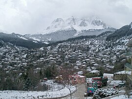 Winter view, with Mt Athamanika in the background | |
 Pramanta Location within the regional unit 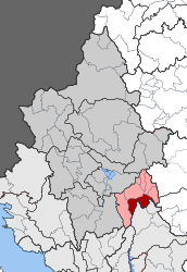 | |
| Coordinates: 39°31′N 21°06′E / 39.517°N 21.100°E | |
| Country | Greece |
| Administrative region | Epirus |
| Regional unit | Ioannina |
| Municipality | North Tzoumerka |
| Area | |
| • Municipal unit | 69.058 km2 (26.663 sq mi) |
| • Community | 39.435 km2 (15.226 sq mi) |
| Population (2021)[1] | |
| • Municipal unit | 1,759 |
| • Municipal unit density | 25/km2 (66/sq mi) |
| • Community | 1,514 |
| • Community density | 38/km2 (99/sq mi) |
| Time zone | UTC+2 (EET) |
| • Summer (DST) | UTC+3 (EEST) |
| Vehicle registration | ΙΝ |
Subdivisions edit
The municipal unit Pramanta is subdivided into the following communities (constituent villages in brackets):
- Ampelochori
- Pramanta (Pramanta, Tsopela, Christoi)
- Raftanaioi (Raftanaioi, Vounoreia, Zalouchos, Megali Rachi, Mylokopeio, Palaiomochousti, Pallikari, Plaka, Rouga, Fraxos)
Population edit
| Year | Village population | Community population | Municipal unit population |
|---|---|---|---|
| 1981 | - | 1,585 | - |
| 1991 | 1,090 | 1,708 | - |
| 2001 | 1,422 | 1,845 | 2,194 |
| 2011 | 1,137 | 1,527 | 1,774 |
| 2021 | 1,214 | 1,514 | 1,759 |
Attractions edit
In the central square one can view the known perennial plane tree, the historic fountain called "Arapis" and the central church of the village, Agia Paraskevi. Close to Pramanta is the "Anemotrypa" cave with its underground river, the 13th century Kipina Monastery built into a rocky mountain, and the mountain retreat in "Isioma".
References edit
- ^ "Αποτελέσματα Απογραφής Πληθυσμού - Κατοικιών 2021, Μόνιμος Πληθυσμός κατά οικισμό" [Results of the 2021 Population - Housing Census, Permanent population by settlement] (in Greek). Hellenic Statistical Authority. 29 March 2024.
- ^ "ΦΕΚ B 1292/2010, Kallikratis reform municipalities" (in Greek). Government Gazette.
- ^ "Population & housing census 2001 (incl. area and average elevation)" (PDF) (in Greek). National Statistical Service of Greece.